Maps of Tower Hamlets
A New & accurate PLAN of the CITIES of LONDON & WSTMINSTER & BOROUGH of SOUTHWARK
This is the sixth edition of a map first published in 1765. It includes views of London landmarks, such as St James's Palace and St Paul's Cathedral, and the arms of the 12 principal City Companies. Dicey was a map seller rather than a cartographer and much of his work is derivative or reissued from earlier plates. This map states that it is printed according to an "Act of Parliament". This makes reference to the Act passed in 1734 to curb the practice of unacknowledged copying. Thereafter, anyone who breached the new 14-yearcopyright period would have to hand over their derivative plates to the master of the original, paying 5 shillings for each offending print on the premises. Cluer Dicey
LONDON 76
This small map of London and suburbs was included in a small 1707French travel book, "Les Delices de la Grande Bretagne". It features a compass rose at bottom right, and a title with reference panel below the plan. Bevereel, James
SMITH'S New Plan of LONDON, WESTMINSTER & SOUTHWARK: comprehending all the New Buildings and 350 References to the Principal Streets
First published by Smith in 1801, this popular map of London went into 27 editions, the last being issued in 1843. The title features along the top, with roads, open spaces, watercourses and the built-up area of the city delineated in colour. A reference table appears in the panel below the plan. Smith, Charles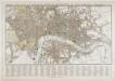
Tegg's new plan of London, &c.
T. Tegg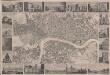
London
This is a "proof before letters", the trade term used for animpression withdrawn by the author before the title and imprint could be added for publication.The map covers London in the 1830s, and is surrounded by small pictorial views of prominent buildings and landmarks including East India House, Marble Arch, Westminster Abbey and Waterloo Bridge. Anonymous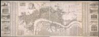
A New & Exact Plan of the Cities of London, & c.
Map of London with title along the top, arms of the 12 principal livery companies at top left with City arms and emblems of the arts. Lists of wards and parishes are reported in a table at bottom left and a descriptive note near bottom centre, with fares of coaches and ferries at bottom right. Down both sides of the map are views of prominent buildings: St Paul's Cathedral, the Banqueting House, the Royal Exchange, Custom House, the Admirably Office, the Royal Palace at St James', Westminster Abbey, Guildhall, the Bank of England, the Tower of London, the Treasury and South Sea House. Foster, George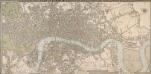
CRUCHLEY'S NEW PLAN OF LONDON IMPROVED TO 1826 INCLUDING THE EAST AND WEST INDIA DOCKS 226
The title of this folding map of London appears inset in the top border, with the publisher’s imprint and key to symbols in the bottom border, the scale bar near the bottom right, and a compass rose at the top right. The river and open spaces are distinguished in colour. The map extends eastward on an added sheet to include the Isle of Dogs and the East and West India Docks. Cruchley, George Frederick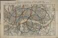
Reynolds's distance map of London, for ascertaining cab fares & shewing the distances in every direction from the railway stations &c.
James Reynolds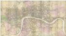
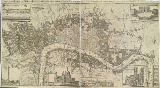
PLAN of the Cities of LONDON and WESTMINSTER the Borough of SOUTHWARK and PARTS adjoining Shewing every HOUSE. By R. Horwood.
This magnificent map covers 32 sheets, each measuring 21" 5/8 x 19" 3/4. It was published sheet by sheet between 1792 and99 and was the work of several engravers under the direction of cartographer Richard Horwood. It is generally considered to be the most important London map of the 18th century. Horwood intended originally to show every house and its number but this was to prove impossible. Although every house is included the numbering was never completed. Horwood dedicated this map to the Trustees and Directors of the Phoenix Fire Office, reflecting that the protection of London from fire was at this time the reserve of numerous independent company brigades. The map is coloured, describing parks in green and the London Wall in red. The Tower of London is shown only by outline; Horwood records that: 'The Internal Parts not distinguished being refused permission to take the Survey’, evidence that a surveyor was not always welcome. Southwark was traditionally a district where the industries of brewing and tanning, unwelcome in the main city, were located. Barclay Perkins & Cos., which in the coming century was to become the largest brewery in the world, is marked on the map, as is Guy's Hospital ("for incurables") which at had recently been extended to include a new hospital for the psychiatrically disturbed. This map was reissued at least four times, with relevant additions and alterations, up until 1819. Horwood, Richard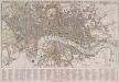
TEGG'S NEW PLAN OF LONDON, &c. WITH 360 REFERENCES TO THE PRINCIPAL STREETS &c.
The title of this folding map of London appears along the top. The city boundaries, open spaces, roads and watercourses are depicted in colour in colour. This is a later edition of a map first issued by Tegg in 1823. It is divided into rectangles for reference, with a street index in panel below the plan. Tegg, Thomas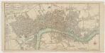
Bowles's new pocket plan of the cities of London & Westminster with the borough of Southwark : comprehending the new buidlings and other alterations to the year 1783
1 : 9800 Bowles, Carington, 1724-1793 Printed for the proprieter Carrington Bowles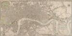
CRUCHLEY'S NEW PLAN OF LONDON IMPROVED TO 1826 INCLUDING THE EAST AND WEST INDIA DOCKS 223
The title of this folding map of London is inset in top border, with the publisher’s imprint and key to symbols in bottom border, scale bar near bottom right, and compass rose at top right. The river and open spaces are highlighted in colour. The map extends eastward on an added sheet to include the East and West India Docks. Cruchley, who first published the map in 1826, added the proposed Collier Docks in the Isle of Dogs to this later edition. The docks were never built and Millwall Docks now occupy part of the site Cruchley, George Frederick
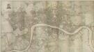
PLAN of the Cities of LONDON and WESTMINSTER the Borough of SOUTHWARK and PARTS adjoining Shewing every HOUSE. By R. Horwood
Map of London printed in 32 sheets and published sheet by sheet between 1792 and 1799, the work of several engravers working to the direction of the cartographer Richard Horwood. Horwood dedicated this map to the Trustees and Directors of the Phoenix Fire Office, reflecting that the protection of London from fire was at this time the reserve of numerous independent company brigades. This edition features a Phoenix at top left with the word "protection" emblazoned beneath it and is uncoloured in its entirety. The Tower of London is shown only by outline, as Horwood records that "The Internal Parts not distinguished being refused permission to take the Survey", testimony that a surveyor was not always welcome. Industries such as brewing and tanning, unwelcome in the city, are located south of the river in Southwark. Barclay Perkins & Co., the largest brewery in the world during the 1800s, is marked on the map, as is Guy's Hospital (for incurables). At the time of this map, the hospital had recently been extended to include a new ward for "lunatics". This map was re-issued, with additions and alterations, at least four times until 1819. Horwood, Richard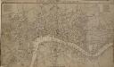
LONDON, WESTMINSTER AND SOUTHWARK, Accurately delineated from the latest Surveys,
John Cary was possibly the most productive maker and publisher of maps in England the 18 Century. His works were reissued many times, but unlike many of his contemporaries he aimed to update each new edition by including new developments. This is the second edition of a map originally published in 1782. The imprint and table of Hackney coach fares (referred to in the description) has been removed from the bottom of the map. Cary, John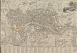
LONDON AND WESTMINSTER 1795
This is the second edition of a map published seven times until 1806. The title is embellished with an engraving of Father Thames, with St Paul's visible in the distance to one side of him. This edition includes an inset plan of the proposed Wet Docks. In 1796, the year this map was published, a Parliamentary Committee attempted to resolve the docking problems such as congestion, delays, lack of warehouse space and theft. The result was a number of project proposals for the building of new docks. However, none of these proposals were carried out, and the problem was not solved until private companies began building enclosed docks in 1802. Fairburn, John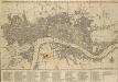
BOWLES'S Reduced NEW POCKET PLAN of the CITIES of LONDON & WESTMINSTER; WITH THE BOROUGH OF SOUTHWARK, exhibiting the New Buildings to the YEAR 1780
The Bowles family were successful map publishers and sellers whose considerable output spanned a century. This map is the second edition of an original 1777plan. It includes a table of references to churches and principal buildings. The built-up areas of the City of London are stippled. The scale is given in miles or furlongs. Bowles, Carington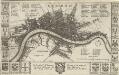
LONDON 45
This map is surveyed by Richard Blome, a heraldic writer and cartographer. Although prolific, he was something of a magpie, borrowing from many sources in the creation of his maps. Engraved by Hollar, this map is dedicated to Sir Robert Vyner, whose coat of arms is depicted at the bottom. The arms of the 12 Great City companies are drawn in the side margins. These companies were the trade guilds of London, many of which have existed from the middle ages to the present day. Hollar, Wenceslaus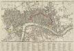
A new Pocket Plan of LONDON WESTMINSTER and SOUTHWARK, with all the Adjacent Buildings. Also a correct List of upwards of 300 Hackney Coach Fares 1797.
Pocket plans were made popular by publisher Thomas Bowles in the 1730s. This later map is coloured to highlight the old London Wall and the parks and open spaces. This map includes a list of Hackney Coach Fares. The development of turnpike roads from the 1750s onwards led to a steady increase of wheeled vehicles such as the Hackney Coach, which eventually made watermen redundant Darton, William and Harvey, Josiah
BOWLES'S Reduced NEW POCKET PLAN of the CITIES of LONDON and WESTMINSTER, with the BOROUGH of SOUTHWARK, exhibiting the NEW BUILDINGS to the YEAR 1787.
This is the sixth edition of Bowles's Reduced New Pocket Plan. The map was reissued 11 times between1777 and 1799. It includes a table of references to churches and principal buildings. The built-up areas of the City of London are represented by stippling; with the city boundaries delineated it red. The scale is given in miles and furlongs. Bowles, Carington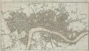
A New & accurate PLAN of the CITIES of LONDON, WSTMINSTER & BOROUGH of SOUTHWARK with the Out Parts & New Buildings completed to the Year 1791.
Born into a family of engravers, Neele issued this map twice in two years with no discernible difference between the editions. The map's title features along the top, with scale bar at upper right and publisher's imprint below the plan. City boundaries are outlined in red; squares and open spaces are highlighted in green. Neele, Samuel John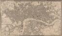
A NEW PLAN OF LONDON AND WESTMINSTER WITH THE BOROUGH OF SOUTHWARK 222
The title of this map appears in a table inset in the top border, with publisher's imprint, scale bar and an explanation of the boundary lines at bottom right. The son of a map publisher, James Wyld attended military college before entering the map trade. He became one of the best-known map publishers of the middle of the 19th Century. During the railway-building mania of those years, his maps of railway developments were often put before parliament. Wyld, James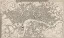
A NEW PLAN OF LONDON AND WESTMINSTER WITH THE BOROUGH OF SOUTHWARK 227
This is the second edition of a map of London first published by Wyld in 1824. Its title features inset in the top border, with publisher's imprint in the bottom border. The scale bar and key to the boundary lines appear at bottom right. The son of a map publisher, James Wyld attended military college before entering the map trade. He became one of the best-known map publishers of the middle of the 19th Century. During the railway-building mania of those years, his maps of railway developments were often put before parliament. Wyld, James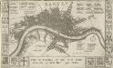
Plan de Londres tel quil Etoit avant l' incendre de 1666 Grave par Hollar
This is a later edition of a 1666map surveyed by Blome and engraved by Hollar. The title appears in French in a panel below the plan, with the key to streets and public buildings appearing in tables at top right, top left and bottom right. A compass star and scale bar are drawn at bottom right. Down both sides of the map are the coats of arms of the 12 Great City Companies (trade guilds), many of which have existed from the middle ages to the present day. Richard Blome was a heraldic writer and cartographer. His maps were often derivative, based on existing sources rather than original surveys. Blome, Richard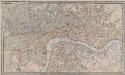
A NEW PLAN OF LONDON AND WESTMINSTER WITH THE BOROUGH OF SOUTHWARK 236
The title of this map of London appears inset in the top border, with the publisher’s imprint below the plan. Open spaces, city boundaries and boroughs are delineated in colour. The key to these colours is provided, with a scale bar, at bottom right. The map is a later edition of a map first published by Wyld in 1824, with the addition of the London-to-Greenwich railway. The line reached Bermondsey from Greenwich in 1836. Ten months later, the line reached London Bridge, making it the first railway terminus in the capital. Wyld, James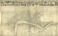
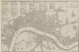
London & c., accurately Surveyed, an accurate Plan of the Cities of London and Westminster and the Borough of Southwark, 1732
This is a later edition of the map of London first issued by Morden and Lea in 1681-82. Printed in 12 sheets, the map features title in banner along the top, portraits of King William and Queen Mary below the title, with the Royal and City arms. Reference tables, compass rose and scale bar at lower right. Along the top of the map are views of Westminster Abbey, the Banqueting Hall, Somerset House, the Mercers' Chapel, the Royal Exchange, Guild Hall and St Paul's Cathedral, with equestrian statues of Charles I and Charles II at top left and right respectively. The map shows Wigmore Street, Grosvenor Square and the Church of St Anne, Limehouse which did not feature in earlier editions of the map. Morden, Robert and Lea, Philip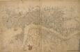
London, Westminster, and Southwark
The map reports all the street names in London, Westminster and Southwark, with the scale bar given at bottom left. Faden, William
This Actuall Survey Of LONDON, WESTMINSTER AND SOUTHWARK Is humbly Dedicated To Y.e L.d M.Yor & Court Of Aldermen by R.o: Morden, Phil: Lea Chr: Browne
This is a later edition of a very popular map of London first published by Morden and Lea in 1690. The map's title features along the top, with the city arms at top left, facing the publisher's imprint in shield at top right. The reference tables, scale bar and compass rose appear at lower right. The plan marks the city's growth in the late Stuart period, showing its northward spread towards Islington. Morden, Robert & Lea, Philip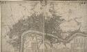
This Actuale Survey of LONDON, WESTMINSTER & SOUTHWARK IS HUMBLY DEDICATED TO Y.e L.D LORD MAYOR & COURT OF ALDERMEN
This later edition of Morden and Lea's 1688 map was published by Covens & Mortier in Amsterdam in 1725. The title appears in English and French in a ribbon along the top. The key to churches, city wards, palaces, halls and companies features in a reference table at the foot of the plate. Jean Covens and Corneil Mortier founded the prestigious printing and publishing house that bears their names in Amsterdam in 1721. Over the years they published wall maps of countries and continents, reissuing many maps, town plans and general atlases by the likes of De Wit, Jaillot and De Lisle. Their heirs continued the business until the 1880s. Morden, Robert & Lea, Philip