Maps of Islington
LONDON 45
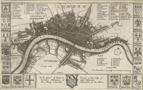
This map is surveyed by Richard Blome, a heraldic writer and cartographer. Although prolific, he was something of a magpie, borrowing from many sources in the creation of his maps. Engraved by Hollar, this map is dedicated to Sir Robert Vyner, whose coat of arms is depicted at the bottom. The arms of the 12 Great City companies are drawn in the side margins. These companies were the trade guilds of London, many of which have existed from the middle ages to the present day. Hollar, Wenceslaus
Plan de Londres tel quil Etoit avant l' incendre de 1666 Grave par Hollar
This is a later edition of a 1666map surveyed by Blome and engraved by Hollar. The title appears in French in a panel below the plan, with the key to streets and public buildings appearing in tables at top right, top left and bottom right. A compass star and scale bar are drawn at bottom right. Down both sides of the map are the coats of arms of the 12 Great City Companies (trade guilds), many of which have existed from the middle ages to the present day. Richard Blome was a heraldic writer and cartographer. His maps were often derivative, based on existing sources rather than original surveys. Blome, Richard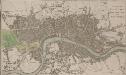
A PLAN OF LONDON WESTMINSTER AND SOUTHWARK
The title of this small map of London appears at top right, with publisher's imprint below the map. The river, city boundaries and open spaces are distinguished by colour use. Phillips, Richard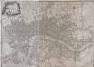
A PLAN of the CITIES of LONDON & WESTMINSTER, THE BOROUGH OF SOUTHWARK and their Suburbs BY WILLIAM FADEN Geogr to the King MDCCLXXXV
The title of this map is arranged in an ornamental surround in which reclines the figure of Thamesis. Cross-hatching and stippling are used to distinguish land use, with differentiation made between fields and park land. Hyde Park features prominently on the plan. Deer were hunted here until 1768.It was also a well-known duelling ground. A particularly protracted and bloody duel was fought in 1772 between a Mr.Sheridan and a Captain Matthews over the honour of a certain Miss Lineley. Reports of the duel appeared in all the papers, scandalising the London public. Faden, William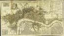
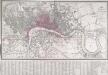
A new and exact plan of the cities of London and Westminster & the borough of Southwark to this present year
1 Plan auf 2 Blättern : Kupferdruck ; 53 x 101 cm Sayer; Bowen printed and published according to act of parliament by Robert Sayer opposite Fetter lane Fleet street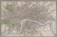
NEW PLAN OF LONDON, WESTMINSTER AND SOUTHWARK
This is a later edition of the map of London, Westminster and Southwark first issued by Gardner in 1827. The map is enclosed in a border and features title along the top, key and scale bar along the bottom, with borough boundaries, open spaces and water courses and main roads in colour. Additions to earlier editions of the map include the Great Western, London and Birmingham, Eastern Counties, Blackwall and Croydon railways. Gardner, James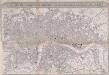
IMPROVED MAP OF LONDON for 1834, from AN ACTUAL SURVEY
The title of this map appears in a panel above the plan, with a scale bar inset in the bottom border. The map extends westward to include Chelsea Beach and shows the proposed tunnel under the Thames at Wapping. The Greenwich-to-London railway line also features. Under construction at the time of this survey, the line reached Bermondsey from Greenwich in 1836. Ten months later the line reached London Bridge, making it the first railway terminus in the capital.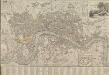
LONDON AND WESTMINSTER 1795
This is the second edition of a map published seven times until 1806. The title is embellished with an engraving of Father Thames, with St Paul's visible in the distance to one side of him. This edition includes an inset plan of the proposed Wet Docks. In 1796, the year this map was published, a Parliamentary Committee attempted to resolve the docking problems such as congestion, delays, lack of warehouse space and theft. The result was a number of project proposals for the building of new docks. However, none of these proposals were carried out, and the problem was not solved until private companies began building enclosed docks in 1802. Fairburn, John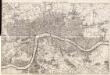
Maps of Old London-J. Rocque
Mitton, Geraldine Edith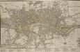
A NEW PLAN OF LONDON, WESTMINSTER AND SOUTHWARK 185
The title of this map appears at top right, with a compass rose and scale bar at bottom right. Below the plan is a list of public offices, with a special section dedicated to those at Somerset House. Designed by William Chambers, Somerset House was built in stages between 1771 and 1835, the first large block ever built to accommodate government offices. Over the years it has housed the Royal Navy, the Stamp Office, Hackney Coaches and Barge Master, the General Register of Births, Deaths and Marriages and the Inland Revenue. Laurie, Robert and Whittle, James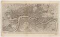
To Martin Folkes esq.r, president of the Royal Society : this plan of the cities of London and Westminster and borough of Southwark, with the contiguous buildings is humbly inscribed
1 : 15000 Rocque, John, d. 1762 John Pine ; John Tinney, print and map sellar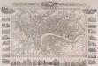
PLAN OF LONDON FROM AN ACTUAL SURVEY 238
This map is set within a decorative border. Its title appears along the top, with the arms of the city, the royal family and Westminster. Around the margin are pictorial views of prominent buildings and landmarks, including the Bank of England, Lambeth Palace, Covent Garden and Waterloo Bridge. The map is a later edition of one first issued as a free supplement of the 'United Kingdom' newspaper in 1832, adding the Greenwich and Birmingham railway lines. Shury, John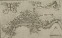
LONDINUM, LONDON
This small map possibly derives from a German work published in Nuremberg.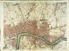
A plan of London
1 Karte : Kupferdruck ; 50 x 66 cm Rocque; Parr publish'd 29.th april according to act of parliament by John Rocque
Londini Angliæ regni metropolis delineatio accuratissima
1 Plan : Kupferdruck ; 34 x 58 cm, Bildgrösse 50 x 58 cm Aa chez Pierre vander Aa libraire imprimeur de l'université et de la ville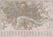
TEGG'S NEW PLAN OF LONDON, &c. WITH 360 REFERENCES TO THE PRINCIPAL STREETS &c.
The title of this folding map of London appears along the top. The city boundaries, open spaces, roads and watercourses are depicted in colour in colour. This is a later edition of a map first issued by Tegg in 1823. It is divided into rectangles for reference, with a street index in panel below the plan. Tegg, Thomas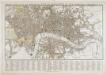
Tegg's new plan of London, &c.
T. Tegg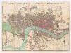
The stranger's guide to London and Westminster exhibiting all the various alterations and improvements, complete to the present time
Mogg, Edward Edward Mogg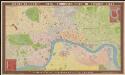
Bauerkeller's new embossed plan of London, 1841
1 : 11500 G. Bauerkeller London [etc.] : Ackermann
MOGG'S NEW LONDON GUIDE, 1849. The Coloured lines exhibit the Omnibus routes.
The "coloured roads" referred to in the title of this map are now faded, with only a pale orange remaining. The circle marked on the map just above St. Paul’s covers a radius of two miles around the Post Office. The Post Office was erected on the site of St Martin-le-Grand. Designed by Sir Robert Smirke, it was opened in 1829.The expanding railway network is evident in the five lines coming into London. Mogg, Edward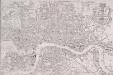
PAYNE'S IMPROVED PLAN OF LONDON
The title of this map appears at top right alongside the publisher’s imprint (in shield) and the city arms. The map is divided in half-mile squares with letters and numbers for reference running along the borders. It shows the Dover, Croydon, Greenwich, Blackwall, Eastern, North London, Great Northern and Birmingham railway lines and their termini. Payne, Albert Henry
LEIGH'S NEW PLAN OF LONDON 212
This is the second edition of a map of London first published in 'Leigh's New Picture of London'. The title appears along the top with a scale bar at the top right. The map is divided into half-mile squares with letters along the top borders for reference. It also shows Southwark Bridge and the proposed New North Road across Finsbury Fields. Hall, S.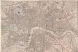
London at a View: a New Map
A copy of Bigg's map of London of 1842 lacking the title, the views and the note at the bottom of the map. The map features scale bar and compass rose at top left with main roads in yellow, water courses in blue, parks and open spaces in green and railways in red. Biggs, George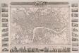
PLAN OF LONDON FROM AN ACTUAL SURVEY 233
This map was issued as a free supplementin the 'United Kingdom' newspaper.Surrounded by a decorative border, the map's title appears in a panel above the plan, with the arms of London, the royal family and the City of Westminster.Inset within the border areillustrations of prominent buildings and landmarks, including the Bank of England, Lambeth Palace, Covent Garden and Waterloo Bridge. The map shows the intended tunnel under the Thames linking Wapping and RotherhitheWhen, the firstunderwater tunnel in the world when it opened in 1843. Shury, John
LONDON 76
This small map of London and suburbs was included in a small 1707French travel book, "Les Delices de la Grande Bretagne". It features a compass rose at bottom right, and a title with reference panel below the plan. Bevereel, James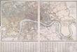
PLAN OF LONDON AND WESTMINSTER with the Borough of SOUTHWARK Being an INDEX to the Large Plan in forty Sheets
This folding map of London was originally published by Faden in 1818 as an index to Harwood's famous map of Regency London. This is a later edition of the map, issued by Wyld when he took over Faden's publishing business. The title, explanation and scale bar feature at top right. The boundaries of London, Westminster, Southwark, Lambeth, Marylebone, Finsbury and Tower Hamlets are outlined in colour. The map is divided into squares with letters and numbers for reference along the margins for reference, with an interpretive key in panel below the plan. Faden, William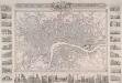
PLAN OF LONDON FROM AN ACTUAL SURVEY 243
This is a later edition of Shury's map of London first issued in 1832. The map features title along the top with the arms of the cities of London and Westminster. Down both sides of the map and along the bottom are 33 views of London buildings and landmarks. The East India House, Custom House, the Mint, St James's Palace, Christ's Hospital, the new Post Office, the bank of England, Hanover Terrace, the Corn Exchange and the Coliseum are depicted down the left side of the plate. Along the bottom are views of St Katherine's Chapel, Caledonian Church, mansion House, the Royal Exchange, Temple Bar, Guild Hall, Buckingham Palace, St Paul's Cathedral, the Monument, St Bride's Church, Lambeth Palace, Westminster Abbey and the entrance to Green Park. Down the right side of the plate are views of the House of Lords, London Bridge, the House of Commons, Waterloo Bridge, Drury Lane Theatre, Horse Guard, the King's College, Covent Garden Theatre, Somerset House and Gloucester Terrace. Shury, John
Londini Angliae regni metropolis delineatio accuratissima / autore F. de Witt
1 : 13000 Wit, Frederik de Amsterdam : F. de Witt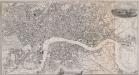
PAYNE'S ILLUSTRATED PLAN OF LONDON
Map of London with title inset in top border, general view of London at top right and view of the House of Parliament at bottom centre. The plan shows Hungerford suspension bridge, with the proposed Waterloo Bridge indicated by a pecked line. Payne, Albert Henry