Maps of Westminster
London, Westminster, and Southwark
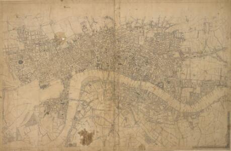
The map reports all the street names in London, Westminster and Southwark, with the scale bar given at bottom left. Faden, William
STRANGER'S GUIDE THROUGH the Streets of LONDON and WESTMINSTER
The title of this folding map appears along the top, with the sub-title in an oval at top right. A scale bar and compass star feature at the bottom right. An inset plan of Fleet Prison is included at top left. Squares, open spaces and built-up areas are all delineated in colour. Intended for visitors to the city, the map is divided into squares, with a quick-reference key in the panel below the main plan. Darton, William
Maps of Old London-J. Rocque
Mitton, Geraldine Edith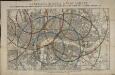
Reynolds's distance map of London, for ascertaining cab fares & shewing the distances in every direction from the railway stations &c.
James Reynolds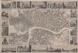
London
This is a "proof before letters", the trade term used for animpression withdrawn by the author before the title and imprint could be added for publication.The map covers London in the 1830s, and is surrounded by small pictorial views of prominent buildings and landmarks including East India House, Marble Arch, Westminster Abbey and Waterloo Bridge. Anonymous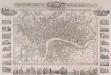
PLAN OF LONDON FROM AN ACTUAL SURVEY 238
This map is set within a decorative border. Its title appears along the top, with the arms of the city, the royal family and Westminster. Around the margin are pictorial views of prominent buildings and landmarks, including the Bank of England, Lambeth Palace, Covent Garden and Waterloo Bridge. The map is a later edition of one first issued as a free supplement of the 'United Kingdom' newspaper in 1832, adding the Greenwich and Birmingham railway lines. Shury, John
The London guide, or, a pocket plan of the cities of London & Westminster & borough of Southwak : with the new buildings &c. to the year 1767
Ellis, J. (John), fl. 1750-1800 Printed for Carington Bowles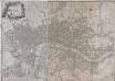
A PLAN of the CITIES of LONDON & WESTMINSTER, THE BOROUGH OF SOUTHWARK and their Suburbs BY WILLIAM FADEN Geogr to the King MDCCLXXXV
The title of this map is arranged in an ornamental surround in which reclines the figure of Thamesis. Cross-hatching and stippling are used to distinguish land use, with differentiation made between fields and park land. Hyde Park features prominently on the plan. Deer were hunted here until 1768.It was also a well-known duelling ground. A particularly protracted and bloody duel was fought in 1772 between a Mr.Sheridan and a Captain Matthews over the honour of a certain Miss Lineley. Reports of the duel appeared in all the papers, scandalising the London public. Faden, William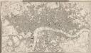
A NEW PLAN OF LONDON AND WESTMINSTER WITH THE BOROUGH OF SOUTHWARK 227
This is the second edition of a map of London first published by Wyld in 1824. Its title features inset in the top border, with publisher's imprint in the bottom border. The scale bar and key to the boundary lines appear at bottom right. The son of a map publisher, James Wyld attended military college before entering the map trade. He became one of the best-known map publishers of the middle of the 19th Century. During the railway-building mania of those years, his maps of railway developments were often put before parliament. Wyld, James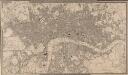
A NEW PLAN OF LONDON AND WESTMINSTER WITH THE BOROUGH OF SOUTHWARK 222
The title of this map appears in a table inset in the top border, with publisher's imprint, scale bar and an explanation of the boundary lines at bottom right. The son of a map publisher, James Wyld attended military college before entering the map trade. He became one of the best-known map publishers of the middle of the 19th Century. During the railway-building mania of those years, his maps of railway developments were often put before parliament. Wyld, James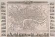
PLAN OF LONDON FROM AN ACTUAL SURVEY 233
This map was issued as a free supplementin the 'United Kingdom' newspaper.Surrounded by a decorative border, the map's title appears in a panel above the plan, with the arms of London, the royal family and the City of Westminster.Inset within the border areillustrations of prominent buildings and landmarks, including the Bank of England, Lambeth Palace, Covent Garden and Waterloo Bridge. The map shows the intended tunnel under the Thames linking Wapping and RotherhitheWhen, the firstunderwater tunnel in the world when it opened in 1843. Shury, John
A NEW PLAN OF LONDON AND WESTMINSTER WITH THE BOROUGH OF SOUTHWARK 236
The title of this map of London appears inset in the top border, with the publisher’s imprint below the plan. Open spaces, city boundaries and boroughs are delineated in colour. The key to these colours is provided, with a scale bar, at bottom right. The map is a later edition of a map first published by Wyld in 1824, with the addition of the London-to-Greenwich railway. The line reached Bermondsey from Greenwich in 1836. Ten months later, the line reached London Bridge, making it the first railway terminus in the capital. Wyld, James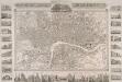
PLAN OF LONDON FROM AN ACTUAL SURVEY WITH ALL THE RAILROADS AND IMPROVEMENTS TO THE PRESENT TIME
This map of Victorian London is set within a decorative border, featuring title and publisher's imprint in a panel above the plan, and views of the city's prominent buildings and landmarks along the margins. This is a later edition of the map first published by Shury in 1832, featuring new railway lines and a pictorial view of Crystal Palace, venue of the Great Exhibition of 1851. Shury, John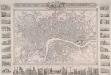
PLAN OF LONDON FROM AN ACTUAL SURVEY 243
This is a later edition of Shury's map of London first issued in 1832. The map features title along the top with the arms of the cities of London and Westminster. Down both sides of the map and along the bottom are 33 views of London buildings and landmarks. The East India House, Custom House, the Mint, St James's Palace, Christ's Hospital, the new Post Office, the bank of England, Hanover Terrace, the Corn Exchange and the Coliseum are depicted down the left side of the plate. Along the bottom are views of St Katherine's Chapel, Caledonian Church, mansion House, the Royal Exchange, Temple Bar, Guild Hall, Buckingham Palace, St Paul's Cathedral, the Monument, St Bride's Church, Lambeth Palace, Westminster Abbey and the entrance to Green Park. Down the right side of the plate are views of the House of Lords, London Bridge, the House of Commons, Waterloo Bridge, Drury Lane Theatre, Horse Guard, the King's College, Covent Garden Theatre, Somerset House and Gloucester Terrace. Shury, John
A NEW PLAN OF LONDON, WESTMINSTER AND SOUTHWARK 185
The title of this map appears at top right, with a compass rose and scale bar at bottom right. Below the plan is a list of public offices, with a special section dedicated to those at Somerset House. Designed by William Chambers, Somerset House was built in stages between 1771 and 1835, the first large block ever built to accommodate government offices. Over the years it has housed the Royal Navy, the Stamp Office, Hackney Coaches and Barge Master, the General Register of Births, Deaths and Marriages and the Inland Revenue. Laurie, Robert and Whittle, James
Tegg's new plan of London, &c.
T. Tegg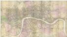
PLAN of the Cities of LONDON and WESTMINSTER the Borough of SOUTHWARK and PARTS adjoining Shewing every HOUSE. By R. Horwood.
This magnificent map covers 32 sheets, each measuring 21" 5/8 x 19" 3/4. It was published sheet by sheet between 1792 and99 and was the work of several engravers under the direction of cartographer Richard Horwood. It is generally considered to be the most important London map of the 18th century. Horwood intended originally to show every house and its number but this was to prove impossible. Although every house is included the numbering was never completed. Horwood dedicated this map to the Trustees and Directors of the Phoenix Fire Office, reflecting that the protection of London from fire was at this time the reserve of numerous independent company brigades. The map is coloured, describing parks in green and the London Wall in red. The Tower of London is shown only by outline; Horwood records that: 'The Internal Parts not distinguished being refused permission to take the Survey’, evidence that a surveyor was not always welcome. Southwark was traditionally a district where the industries of brewing and tanning, unwelcome in the main city, were located. Barclay Perkins & Cos., which in the coming century was to become the largest brewery in the world, is marked on the map, as is Guy's Hospital ("for incurables") which at had recently been extended to include a new hospital for the psychiatrically disturbed. This map was reissued at least four times, with relevant additions and alterations, up until 1819. Horwood, Richard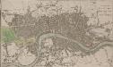
A PLAN OF LONDON WESTMINSTER AND SOUTHWARK
The title of this small map of London appears at top right, with publisher's imprint below the map. The river, city boundaries and open spaces are distinguished by colour use. Phillips, Richard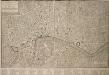
PLAN OF LONDON WESTMINSTER and the BOROUGH of SOUTHWARK with all the additional Streets, Squares, & c also the improved ROADS to the Year (1772) From the best Authors.
This map includes Finsbury Fields and Newington. Field boundaries are indicated. A table of references for public buildings is included. Buildings are shown in plan form. The internal structures of the Tower of London are detailed. Bonnisselle, J.G.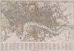
TEGG'S NEW PLAN OF LONDON, &c. WITH 360 REFERENCES TO THE PRINCIPAL STREETS &c.
The title of this folding map of London appears along the top. The city boundaries, open spaces, roads and watercourses are depicted in colour in colour. This is a later edition of a map first issued by Tegg in 1823. It is divided into rectangles for reference, with a street index in panel below the plan. Tegg, Thomas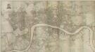
PLAN of the Cities of LONDON and WESTMINSTER the Borough of SOUTHWARK and PARTS adjoining Shewing every HOUSE. By R. Horwood
Map of London printed in 32 sheets and published sheet by sheet between 1792 and 1799, the work of several engravers working to the direction of the cartographer Richard Horwood. Horwood dedicated this map to the Trustees and Directors of the Phoenix Fire Office, reflecting that the protection of London from fire was at this time the reserve of numerous independent company brigades. This edition features a Phoenix at top left with the word "protection" emblazoned beneath it and is uncoloured in its entirety. The Tower of London is shown only by outline, as Horwood records that "The Internal Parts not distinguished being refused permission to take the Survey", testimony that a surveyor was not always welcome. Industries such as brewing and tanning, unwelcome in the city, are located south of the river in Southwark. Barclay Perkins & Co., the largest brewery in the world during the 1800s, is marked on the map, as is Guy's Hospital (for incurables). At the time of this map, the hospital had recently been extended to include a new ward for "lunatics". This map was re-issued, with additions and alterations, at least four times until 1819. Horwood, Richard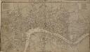
LONDON, WESTMINSTER AND SOUTHWARK, Accurately delineated from the latest Surveys,
John Cary was possibly the most productive maker and publisher of maps in England the 18 Century. His works were reissued many times, but unlike many of his contemporaries he aimed to update each new edition by including new developments. This is the second edition of a map originally published in 1782. The imprint and table of Hackney coach fares (referred to in the description) has been removed from the bottom of the map. Cary, John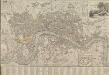
LONDON AND WESTMINSTER 1795
This is the second edition of a map published seven times until 1806. The title is embellished with an engraving of Father Thames, with St Paul's visible in the distance to one side of him. This edition includes an inset plan of the proposed Wet Docks. In 1796, the year this map was published, a Parliamentary Committee attempted to resolve the docking problems such as congestion, delays, lack of warehouse space and theft. The result was a number of project proposals for the building of new docks. However, none of these proposals were carried out, and the problem was not solved until private companies began building enclosed docks in 1802. Fairburn, John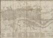
BOWLES'S Reduced NEW POCKET PLAN of the CITIES of LONDON and WESTMINSTER, with the BOROUGH of SOUTHWARK, exhibiting the NEW BUILDINGS to the YEAR 1787.
This is the sixth edition of Bowles's Reduced New Pocket Plan. The map was reissued 11 times between1777 and 1799. It includes a table of references to churches and principal buildings. The built-up areas of the City of London are represented by stippling; with the city boundaries delineated it red. The scale is given in miles and furlongs. Bowles, Carington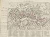
HARRIS'S PLAN of LONDON, WESTMINSTER and the BOROUGH of SOUTHWARK, with all the additional Streets, Squares &c; also the improved ROADS to the Year 1791.
This is the sixth edition of an original 1779map. Differences between this edition and the previous one suggest that the plate was re-engraved, at least in part, as new and proposed buildings have been added. Most strikingly, 20 proposed locations for fire stations are depicted, along with their catchment areas. The Metropolitan Fire Brigade was not formed until 1865. A number of different company brigades had co-operated with each other as the London Fire Engine Establishment since 1833. The failure of this service to stop the destruction of the Houses of Parliament in 1837led to criticism, increasing when a fire in Tooley Street raged for two days. Harris, John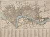
A NEW PLAN OF LONDON with the Names of the Streets Alphabetically arranged at Bottom with directions to find them in the Map
The title of this map appears along the top and with the river, city boundaries and open spaces depicted in different colours. The map is divided into numbered squares for reference, with a key in the table below the plan. Samuel Fores, better known as a publisher of sporting prints, first issued this map in 1789; this is a later edition, updated to include the housing developments of Sommers Town and St. George's Field. Fores, Samuel W.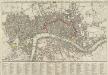
A new Pocket Plan of LONDON WESTMINSTER and SOUTHWARK, with all the Adjacent Buildings. Also a correct List of upwards of 300 Hackney Coach Fares 1797.
Pocket plans were made popular by publisher Thomas Bowles in the 1730s. This later map is coloured to highlight the old London Wall and the parks and open spaces. This map includes a list of Hackney Coach Fares. The development of turnpike roads from the 1750s onwards led to a steady increase of wheeled vehicles such as the Hackney Coach, which eventually made watermen redundant Darton, William and Harvey, Josiah
HARRIS'S PLAN of LONDON, WESTMINSTER and the BOROUGH of SOUTHWARK, with all the additional Streets, Squares &c; also the improved ROADS to the Year 1794.
This map is the seventh edition of an original plan of1779. Differences between the fifth and sixth edition five suggest that the plate was re-engraved, at least in parts, as additional buildings appear in the sixth edition, dating from 1791.This edition claims to show London as it was in 1794, although no discernible features distinguish it from the previous edition. An alphanumeric table of references and a grid of half-mile squares aids orientation. A small diagram in the bottom right corner instructs the user on how to use the grid. The bottom margin has been trimmed away, removing the print seller's imprint. Harris, John
LEIGH'S NEW PLAN OF LONDON 212
This is the second edition of a map of London first published in 'Leigh's New Picture of London'. The title appears along the top with a scale bar at the top right. The map is divided into half-mile squares with letters along the top borders for reference. It also shows Southwark Bridge and the proposed New North Road across Finsbury Fields. Hall, S.