Maps of Devon

DEVONIAE COMOTAT
This map of Devon is by Christopher Saxton and dates from 1575. It forms part of an atlas that belonged to William Cecil Lord Burghley, Secretary of State to Elizabeth I. Burghley used this atlas to illustrate domestic matters. This map is actually a proof copy of one which forms part of Christopher Saxton’s Atlas of England and Wales. This atlas was first published as a whole in 1579. It consists of 35 coloured maps depicting the counties of England and Wales. The atlas is of great significance to British cartography as it set a standard of cartographic representation in Britain and the maps remained the basis for English county mapping, with few exceptions, until after 1750. During the reign of Elizabeth I map use became more common, with many government matters referring to increasingly accurate maps with consistent scales and symbols, made possible by advances in surveying techniques. This map was produced under the patronage of Thomas Seckford, a Master of Requests to Elizabeth I, who had commissioned Saxton’s atlas of county maps, a project overseen by Lord Burghley, Secretary of State, whose administration increasingly involved the use of maps. This map is interesting as there are several notes in the margins. In the lower right hand margin: 'A Note of hir maties Store of Ordonnaunce, powder and match, lead,&c.,remayningin ye L. Lieutenauntes, &c. hands'. In the upper right hand margin 'A Note what powder and match was appointed to be kept in store in every corporate towne'. In the left hand margin 'A Breef Note of ye places of Descent. . . yt are most daungerous and require greatest regard and assistaunce'. These annotations were most probably made by an assistant of Lord Burghley’s, and show the concern felt about coastal areas in the face of the threat from Spain which culminated in 1588 with the events of the Spanish Armada. Saxton, Christopher Hogenbergius, Remigius
DEVONIAE COMITAT
This map of Devon is from the 1583 edition of the Saxton atlas of England and Wales. This atlas was first published as a whole in 1579. It consists of 35 coloured maps depicting the counties of England and Wales. The atlas is of great significance to British cartography as it set a standard of cartographic representation in Britain and the maps remained the basis for English county mapping, with few exceptions, until after 1750. During the reign of Elizabeth I map use became more common, with many government matters referring to increasingly accurate maps with consistent scales and symbols, made possible by advances in surveying techniques. Illustrating the increasing used of maps in government matters, Lord Burghley, Elizabeth I’s Secretary of State, who had been determined to have England and Wales mapped in detail from the 1550s, selected the cartographer Christopher Saxton to produce a detailed and consistent survey of the country. The financier of the project was Thomas Seckford Master of Requests at the Court of Elizabeth I, whose arms appear, along with the royal crest, on each map. The decorative scale bar houses the name of Saxton and of the Flemish engraver Remigius Hogenberg who prepared the copper plate for this map. This is the only map in the atlas that features a compass rose as well as the cardinal points in the borders, seeming to indicate the Devon has been turned slightly clockwise to fit the plate. Two ships engaging in battle are depicted off the coast of Plymouth, perhaps making reference to the vulnerability of this section of south coast and the location of naval bases. Saxton, Christopher Ryther, Augustine
A new map of the County of Devon
London : C. Smith
DEVONIA | vulgo | DEVON-SHIRE.
[Amsterdam : Joan Blaeu]
Devoniae Descriptio. The Description of Devon-Shire [Karte], in: Novus atlas absolutissimus, Bd. 7, S. 199.
1 Karte aus Atlas Janssonius Offizin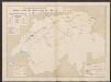
Devonia vulgo Devon-Shire. [Karte], in: Le théâtre du monde, ou, Nouvel atlas contenant les chartes et descriptions de tous les païs de la terre, Bd. 4, S. 120.
1 Karte aus Atlas Blaeu, Willem Janszoon und Blaeu, Joan Blaeu, Willem Janszoon
Devoniae descriptio = The description of Devon-Shire
1 : 180000 Amstelodami : apud Joannem Janssonium
An accurate map of Devon Shire
1 Karte : Kupferdruck ; 50 x 65 cm Bowen; Tinney sold by I. Tinney at the Golden Lion in Fleet street
Devonia vulgo Devon-Shire
1 Karte : Kupferdruck ; 38 x 49 cm Blaeu Joan Blaeu
Devonia Vulgo Devon-Shire. [Karte], in: Theatrum orbis terrarum, sive, Atlas novus, Bd. 4, S. 136.
1 Karte aus Atlas Blaeu, Joan Blaeu, Willem Janszoon
Devonia Vulgo Devon-Shire. [Karte], in: Theatrum orbis terrarum, sive, Atlas novus, Bd. 4, S. 136.
1 Karte aus Atlas Blaeu, Joan Blaeu, Willem Janszoon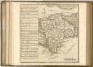

Devonshire
1 : 640000 Devon (Anglie) Hall, Sid. by Chapman & Hall
South Devon, Sheet 36 - Bartholomew's "Half Inch to the Mile Maps" of England & Wales
1 : 126720 Topographic maps Bartholomew, John George John Bartholomew & Co
North Devon, Sheet 35 - Bartholomew's "Half Inch to the Mile Maps" of England & Wales
1 : 126720 Topographic maps Bartholomew, John George John Bartholomew & Co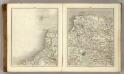
Sheets 11-12. (Cary's England, Wales, and Scotland).
1 : 360000 Cary, John, ca. 1754-1835
Okehampton - OS One-Inch Map
1 : 63360 Topographic maps Ordnance Survey Ordnance Survey
Exeter - OS One-Inch Map
1 : 63360 Topographic maps Ordnance Survey Ordnance Survey
Cary's Improved Map of England and Wales
Cary, George, & Cary, John London : G. & J. Cary
Torquay - OS One-Inch Map
1 : 63360 Topographic maps Ordnance Survey Ordnance Survey
Dartmoor, Devon
This drawing shows the estuary of the River Dart flowing into the English Channel. Numerous slate and limestone quarries surround the busy port at Dartmouth Harbour. Dartmouth Port also served the tin and copper mines on Dartmoor. Tan yards are marked at Totnes and Ashburton. Many cider orchards are noted. An Old Cross is drawn at Saint Petrocks (St Petrox) near the ruins of a castle across the estuary at Kiln Cove. Another castle appears at Totnes. The ancient earthworks at Woodbury Camp and many other early settlements are recorded in this area. While the authorship of this drawing is unknown, the elaborate hill shading and attention to communications routes conform to the military and cartographic standards employed by the West Country survey. The map is made up of three pieces. Its margins are trimmed and the drawing is in good condition.
Plymouth - OS One-Inch Map
1 : 63360 Topographic maps Ordnance Survey Ordnance Survey
South Molton, Devon
This relief on this drawing,is indicated by dense interlining ('hachures'), with,the summits of hills left blank. The drawing has been made on three pieces of paper mounted as one sheet., Dirty, worn and creased, the manuscript is difficult to decipher. ,A pencil note at the base of the drawing reads "To survey from * to * as ...by...the Farms as named."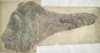
Oakhampton, Devon
1 : 31680 This dirty and worn plan is made from two pieces of paper conjoined. Place names are difficult to read. High Willhays (High Willhayse) and Yes Tor, two of Dartmoor's highest points, are badly obscured by the dense drawing style used to represent relief. A green wash indicates Dartmoor Forest. The remains of Oakhampton Castle are marked by a crosshatched mound. A red line passes through the drawing on the left edge. Two crosses may mark observation or triangulation points.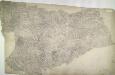
Holsworthy, Devon
Pencil annotations on the bottom right of the map give the surveyors name and the drawing's date and scale. A red dashed line denotes the border of Devon and Cornwall, running partly along the course of the River Tamer. Pencil rays intersect across the plan, evidence of triangulation measurements taken by the surveyor. Although it did not become obligatory to include archaeological details until 1816, prehistoric defensive earthworks are noted at Warbstow Barrow . A windmill is shown in elevation at Holsworthy. Budgen, Charles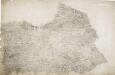
Hartland, Devon
A dashed red line marks the county boundary between Cornwall and Devon at the bottom left of the manuscript. Depicted throughout the area, Devon's mills provided the East India Company with woven serges by the ton until the early 19th century. Coarse woollen cloths, blankets and fine lace were also woven throughout the county. Budgen, Charles
Bodmin and Launceston - OS One-Inch Map
1 : 63360 Topographic maps Ordnance Survey Ordnance Survey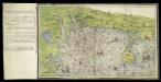
Ottermouth Haven [Coasts of Devon and Dorset from Dartmouth to Weymouth with a written description of Ottermouth Haven]
This is a map of the coast of Devon and Cornwall from Dartmouth to Weymouth which forms part of an atlas that belonged to William Cecil Lord Burghley, Secretary of State to Elizabeth I. Burghley used this atlas to illustrate domestic matters. This map shows the coastline in a pictorial fashion, with buildings indicated by generic, rather than individualized images of various building types. In the left hand margin is a written description of Ottermouth haven, which also features on the map itself. A dominating feature of the map in the compass rose in the centre which has lines radiating from it, each with a direction written along side it. From the style of the lettering and the depiction of the ships the map can be dated to the around 1540. Lord Burghley has annotated the map, adding a we’y of xviii foot brod’ to a narrow bridge of land and adding Sandfoot castle to the coastline to the right of the Isle Portland. The map may have originally been drawn in connection with the 1539-40 invasion scare caused by the alliance against England of France and Spain. The fortification of the Dorset coast was an essential part of the defensive preparations and in April 1539 Lord Russell surveyed the area, sending a plat’ to Cromwell which suggested a much more ambitious fortification program than was actually carried out. Sandfoot, which Lord Burghley has inserted onto this map, was in commission by 1541-1542. The fact that it does not originally appear on the map suggests that it was not built at the time of the maps execution. This is curious however as Portland Castle, built at the same time as Sandfoot, was included by the original draughtsman. The castles were intended to be able to cross fire over the important anchorage known as Portland Roads. Lord Burghley’s interest in the area can be attributed to a new invasion threat from Spain. This threat was also rooted in religious ideology as the Catholic Philip II of Spain wanted to remove the ardently Protestant Elizabeth I from the English Throne. Unfortunately, the coastal forts in Dorset, as with others in England, had been allowed to fall into disrepair. Finally in 1584 action to repair the Dorset forts was authorised by the Privy Council. William Cecil, Lord Burghley
Barnstaple - OS One-Inch Map
1 : 63360 Topographic maps Ordnance Survey Ordnance Survey


