Maps of South Hams

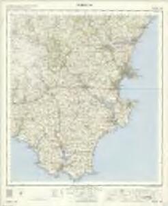
Torquay - OS One-Inch Map
1 : 63360 Topographic maps Ordnance Survey Ordnance Survey
Plymouth - OS One-Inch Map
1 : 63360 Topographic maps Ordnance Survey Ordnance Survey
Dartmoor, Devon
This drawing shows the estuary of the River Dart flowing into the English Channel. Numerous slate and limestone quarries surround the busy port at Dartmouth Harbour. Dartmouth Port also served the tin and copper mines on Dartmoor. Tan yards are marked at Totnes and Ashburton. Many cider orchards are noted. An Old Cross is drawn at Saint Petrocks (St Petrox) near the ruins of a castle across the estuary at Kiln Cove. Another castle appears at Totnes. The ancient earthworks at Woodbury Camp and many other early settlements are recorded in this area. While the authorship of this drawing is unknown, the elaborate hill shading and attention to communications routes conform to the military and cartographic standards employed by the West Country survey. The map is made up of three pieces. Its margins are trimmed and the drawing is in good condition.
Kingsbridge, Devon
This drawing covers the coastal region around Salcombe, from Bantham and Thurlestone on to Stoke Fleming., It is attributed to Royal Military Surveyor and Draughtsman, Richard Searle, who took part in the West Country Survey from 1803 to 1807., He was one of the most competent surveyors to work on the survey, and taught gentlemen cadets the basics of surveying., Despite this,,he was only rated second-class in the Corps., On this map, the heavy-ink colour washes indicating the steepness of the hills make some of the,inland symbols,difficult to interpret.,,Square gridlines in pencil are prominent at the edges of the map, made to facilitate copying., The manuscript paper carries a watermark from the,James Whatman Turkey Mill., Searle, Richard
Ashburton(002OSD000000001U00018000)
Draughtsmen used the colour red to indicate stone, so the unbroken red line around Huntingdon Warren in the centre of the,map means that it was enclosed by a stone wall., Field boundaries are also shown, with those in red again representing stone walls., Notably, the draughtsman has drawn pecked red lines on this map, most obviously at Yealm River in the central left area., These may have represented stone circles., Place names are truncated where the margins of the manuscript have been trimmed. Dawson, Robert
Torquay (Outline) - OS One-Inch Revised New Series
1 : 63360 Topographic maps Ordnance Survey Ordnance Survey
Torquay (Hills) - OS One-Inch Revised New Series
1 : 63360 Topographic maps Ordnance Survey Ordnance Survey
Start Point (Outline) - OS One-Inch Revised New Series
1 : 63360 Topographic maps Ordnance Survey Ordnance Survey
Start Point (Hills) - OS One-Inch Revised New Series
1 : 63360 Topographic maps Ordnance Survey Ordnance Survey
Teignmouth (Hills) - OS One-Inch Revised New Series
1 : 63360 Topographic maps Ordnance Survey Ordnance Survey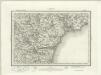
Teignmouth (Outline) - OS One-Inch Revised New Series
1 : 63360 Topographic maps Ordnance Survey Ordnance Survey
Torbay, Devon
Relief is shown on this drawing by dense brushwork interlining ('hachures'), with the summits of inclines left bare. It is partly the concern with accurate representation of relief that sets these drawings apart from the earlier county maps. Individual trees are shown with their shadows falling to the left. Rocky outcrops in Tor Bay are shown and the beach is tinted yellow. Quarter-inch squares, used to facilitate copying or reduction of the map, can be seen in pencil around the coastline. The drawing has been titled in ink and the scale is noted in the bottom left. It is not orientated to the north. Stanley, William
Ashburton(002OSD000000001U00017000)
Draughtsmen would sometimes rotate the area they were mapping to fit in to the available paper. Hence, this map is not orientated with north at the top. Earthworks around Ashburton and Ashburton Down, near the bottom of the drawing, are depicted by short, open, circular strokes ('hachures') in black. Around Holne Chase, to the left of the picture, feathered arrows describe the flow of the River Dart beyond two points of confluence. Dawson, Robert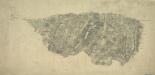
Dartmoor Prison, Devon
Her Majesty's Prison at Dartmoor in Devon was built in 1802 for French captives. It appears at the top left of this drawing, alongside the words 'Prison of War'. The map is not conventionally orientated with north at the top. A turnpike road running from Moretonhampstead to Randlestown, coloured yellow, forms the upper boundary. The mileage from Moretonhampstead is noted along its route. This map follows the military practice of showing stone and brick structures in red or brown, and those built from less permanent materials, such as wood, in black or sepia. Individual stones are drawn in brown ink at the numerous 'tor' (hill) sites in this section of Dartmoor Forest. Hamilton Beacon ('Hameldown Beacon') is a pinprick mark surrounded by a pencil circle on Hamilton Down ('Hamel Down'). This may have been used as an observation or triangulation station. Hewitt, John
Kingsbridge (Hills) - OS One-Inch Revised New Series
1 : 63360 Topographic maps Ordnance Survey Ordnance Survey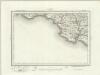
Kingsbridge (Outline) - OS One-Inch Revised New Series
1 : 63360 Topographic maps Ordnance Survey Ordnance Survey
Ivybridge (Hills) - OS One-Inch Revised New Series
1 : 63360 Topographic maps Ordnance Survey Ordnance Survey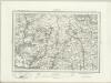
Ivybridge (Outline) - OS One-Inch Revised New Series
1 : 63360 Topographic maps Ordnance Survey Ordnance Survey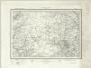
Dartmoor Forest (Outline) - OS One-Inch Revised New Series
1 : 63360 Topographic maps Ordnance Survey Ordnance Survey
Dartmoor Forest (Hills) - OS One-Inch Revised New Series
1 : 63360 Topographic maps Ordnance Survey Ordnance Survey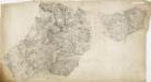
Exmouth
This plan of the area around the mouth of the River Exe is comprised of two sheets joined together. The meticulous detail of the survey extends to recording sandbanks and details of the river bed. Relief is indicated by interlining ('hachuring') and shading. Stippling and stripes distinguish different land usage. A faint blue line with a quartered circle extending into Holcombe Down, at centre bottom, is probably an observation or measuring line. Annotations in pencil record the scale and date of the survey. At the bottom-right edge, "Part of the Ordn[ance"] is written ink. Stanley, William
Bovey Tracey
The military impetus of the Ordnance Survey is evident in the draughtsmen's preoccupation in detailing the lie of the land, not just its topographical features. Relief is indicated here by shading and the use of short disconnected lines drawn in the direction of the slopes - a technique called hachuring. Woods are coloured green. Red crosses and dots around the outer edge of the landmass indicate observation stations, which were used to plot distinctive features of the land being surveyed. The main roads are marked at mile intervals. Hewitt, John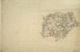
Modbury, Devon
This drawing plots the estuaries of the Rivers Erme and Avon on the south Devon coast., The survey date is noted at the bottom right of the manuscript, along with the scale., The draughtsman is unknown, but the elaborate hill-shading and attention to communications routes conform to the military and cartographic standards employed in the overall survey., Square gridlines in pencil are visible at the boundaries of the map, made to facilitate copying.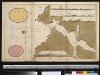
De rivier van Salcombe int groot
England Gerard van Keulen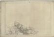
Devonshire CXVI - OS Six-Inch Map
1 : 10560 Topographic maps Ordnance Survey Ordnance Survey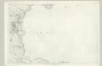
Devonshire CXXII - OS Six-Inch Map
1 : 10560 Topographic maps Ordnance Survey Ordnance Survey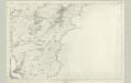
Devonshire CXXVIII - OS Six-Inch Map
1 : 10560 Topographic maps Ordnance Survey Ordnance Survey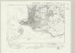
Devonshire CIII.NW - OS Six-Inch Map
1 : 10560 Topographic maps Ordnance Survey Ordnance Survey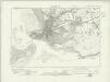
Devonshire CIII.NW - OS Six-Inch Map
1 : 10560 Topographic maps Ordnance Survey Ordnance Survey