Maps of South Hams

Kingsbridge, Devon
This drawing covers the coastal region around Salcombe, from Bantham and Thurlestone on to Stoke Fleming., It is attributed to Royal Military Surveyor and Draughtsman, Richard Searle, who took part in the West Country Survey from 1803 to 1807., He was one of the most competent surveyors to work on the survey, and taught gentlemen cadets the basics of surveying., Despite this,,he was only rated second-class in the Corps., On this map, the heavy-ink colour washes indicating the steepness of the hills make some of the,inland symbols,difficult to interpret.,,Square gridlines in pencil are prominent at the edges of the map, made to facilitate copying., The manuscript paper carries a watermark from the,James Whatman Turkey Mill., Searle, Richard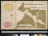
De rivier van Salcombe int groot
England Gerard van Keulen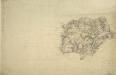
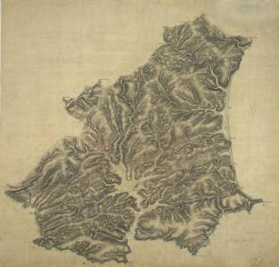
Modbury, Devon
This drawing plots the estuaries of the Rivers Erme and Avon on the south Devon coast., The survey date is noted at the bottom right of the manuscript, along with the scale., The draughtsman is unknown, but the elaborate hill-shading and attention to communications routes conform to the military and cartographic standards employed in the overall survey., Square gridlines in pencil are visible at the boundaries of the map, made to facilitate copying.
Devonshire CXXVII.SE - OS Six-Inch Map
1 : 10560 Topographic maps Ordnance Survey Ordnance Survey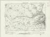
Devonshire CXXVII.SE - OS Six-Inch Map
1 : 10560 Topographic maps Ordnance Survey Ordnance Survey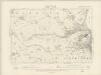
Devonshire CXXVII.SE - OS Six-Inch Map
1 : 10560 Topographic maps Ordnance Survey Ordnance Survey
Devonshire CXXVII.SE - OS Six-Inch Map
1 : 10560 Topographic maps Ordnance Survey Ordnance Survey
Devonshire CXXXIII.NE - OS Six-Inch Map
1 : 10560 Topographic maps Ordnance Survey Ordnance Survey
Devonshire CXXXIII.NE - OS Six-Inch Map
1 : 10560 Topographic maps Ordnance Survey Ordnance Survey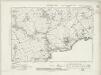
Devonshire CXXXIII.NE - OS Six-Inch Map
1 : 10560 Topographic maps Ordnance Survey Ordnance Survey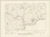
Devonshire CXXXIII.NE - OS Six-Inch Map
1 : 10560 Topographic maps Ordnance Survey Ordnance Survey
Devonshire CXXXIII.NE - OS Six-Inch Map
1 : 10560 Topographic maps Ordnance Survey Ordnance Survey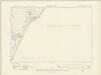
Devonshire CXXXIII.SE - OS Six-Inch Map
1 : 10560 Topographic maps Ordnance Survey Ordnance Survey
Devonshire CXXXIII.SE - OS Six-Inch Map
1 : 10560 Topographic maps Ordnance Survey Ordnance Survey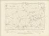
Devonshire CXXVII.SW - OS Six-Inch Map
1 : 10560 Topographic maps Ordnance Survey Ordnance Survey
Devonshire CXXVII.SW - OS Six-Inch Map
1 : 10560 Topographic maps Ordnance Survey Ordnance Survey
Devonshire CXXXIX.NE - OS Six-Inch Map
1 : 10560 Topographic maps Ordnance Survey Ordnance Survey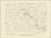
Devonshire CXXXIII.NW - OS Six-Inch Map
1 : 10560 Topographic maps Ordnance Survey Ordnance Survey
Devonshire CXXXIII.NW - OS Six-Inch Map
1 : 10560 Topographic maps Ordnance Survey Ordnance Survey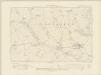
Devonshire CXXXIII.SW - OS Six-Inch Map
1 : 10560 Topographic maps Ordnance Survey Ordnance Survey
Devonshire CXXXIII.SW - OS Six-Inch Map
1 : 10560 Topographic maps Ordnance Survey Ordnance Survey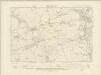
Devonshire CXXVI.SW - OS Six-Inch Map
1 : 10560 Topographic maps Ordnance Survey Ordnance Survey
Devonshire CXXVI.SW - OS Six-Inch Map
1 : 10560 Topographic maps Ordnance Survey Ordnance Survey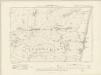
Devonshire CXXXVII.NW & NE - OS Six-Inch Map
1 : 10560 Topographic maps Ordnance Survey Ordnance Survey
Devonshire CXXXVII.NW & NE - OS Six-Inch Map
1 : 10560 Topographic maps Ordnance Survey Ordnance Survey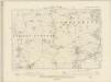
Devonshire CXXXII.NW - OS Six-Inch Map
1 : 10560 Topographic maps Ordnance Survey Ordnance Survey
Devonshire CXXXII.NW - OS Six-Inch Map
1 : 10560 Topographic maps Ordnance Survey Ordnance Survey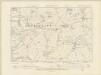
Devonshire CXXVI.SE - OS Six-Inch Map
1 : 10560 Topographic maps Ordnance Survey Ordnance Survey
Devonshire CXXVI.SE - OS Six-Inch Map
1 : 10560 Topographic maps Ordnance Survey Ordnance Survey
Devonshire CXXXVII.SW - OS Six-Inch Map
1 : 10560 Topographic maps Ordnance Survey Ordnance Survey