Maps of West Devon

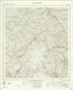
Okehampton - OS One-Inch Map
1 : 63360 Topographic maps Ordnance Survey Ordnance Survey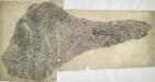
Oakhampton, Devon
1 : 31680 This dirty and worn plan is made from two pieces of paper conjoined. Place names are difficult to read. High Willhays (High Willhayse) and Yes Tor, two of Dartmoor's highest points, are badly obscured by the dense drawing style used to represent relief. A green wash indicates Dartmoor Forest. The remains of Oakhampton Castle are marked by a crosshatched mound. A red line passes through the drawing on the left edge. Two crosses may mark observation or triangulation points.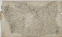
Crediton
.Wear and tear aorund the edges of this drawing have given it an irregular shape. The scale of the plan and date of execution are recorded in pencil in the bottom right corner. Major lines of communication, such as that between Credition and Newton St Cyres, are marked at intervals of one mile and tinted yellow, conforming to military cartographic convention. A blue cross at the edge of the map, near Hatherleigh, marks a reference point that may have been used for observation.
Okehampton (Hills) - OS One-Inch Revised New Series
1 : 63360 Topographic maps Ordnance Survey Ordnance Survey
Okehampton (Outline) - OS One-Inch Revised New Series
1 : 63360 Topographic maps Ordnance Survey Ordnance Survey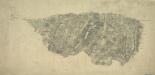
Dartmoor Prison, Devon
Her Majesty's Prison at Dartmoor in Devon was built in 1802 for French captives. It appears at the top left of this drawing, alongside the words 'Prison of War'. The map is not conventionally orientated with north at the top. A turnpike road running from Moretonhampstead to Randlestown, coloured yellow, forms the upper boundary. The mileage from Moretonhampstead is noted along its route. This map follows the military practice of showing stone and brick structures in red or brown, and those built from less permanent materials, such as wood, in black or sepia. Individual stones are drawn in brown ink at the numerous 'tor' (hill) sites in this section of Dartmoor Forest. Hamilton Beacon ('Hameldown Beacon') is a pinprick mark surrounded by a pencil circle on Hamilton Down ('Hamel Down'). This may have been used as an observation or triangulation station. Hewitt, John
Dartmoor Forest (Outline) - OS One-Inch Revised New Series
1 : 63360 Topographic maps Ordnance Survey Ordnance Survey
Dartmoor Forest (Hills) - OS One-Inch Revised New Series
1 : 63360 Topographic maps Ordnance Survey Ordnance Survey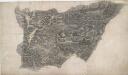
Launceston
A red dashed line running along the path of the River Tamer denotes the border between Devon and Cornwall. The settlement at Launceston appears on the Cornish side of the border. On the bottom right of the manuscript, Budgens calculations of the area survive in red ink as do triangulation lines. The map is drawn on an irregularly cut sheet which is torn and pieced together with detail extending over the joins. Archaeological details such as at Rowdown Barrows are documented even though recording such sites did not become obligatory until 1816. Budgen, Charles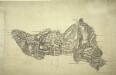
Tavistock
The border between Devon and Cornwall is shown running along the River Tamer from Horse Bridge to New Bridge., Mining is evident around Peter Tavy to the central right of the picture, while Mill Hill Slate Quarry is prominent in the middle of the region., There are more quarries just above Sampford Spiny, to the bottom right of the map., At the topmost point is Brent Tor, with the Church of St Michael enclosed by a red boundary signifying a stone wall., Authorship is unconfirmed.
Ashburton(002OSD000000001U00017000)
Draughtsmen would sometimes rotate the area they were mapping to fit in to the available paper. Hence, this map is not orientated with north at the top. Earthworks around Ashburton and Ashburton Down, near the bottom of the drawing, are depicted by short, open, circular strokes ('hachures') in black. Around Holne Chase, to the left of the picture, feathered arrows describe the flow of the River Dart beyond two points of confluence. Dawson, Robert
Chulmleigh (Hills) - OS One-Inch Revised New Series
1 : 63360 Topographic maps Ordnance Survey Ordnance Survey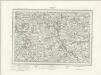
Chulmleigh (Outline) - OS One-Inch Revised New Series
1 : 63360 Topographic maps Ordnance Survey Ordnance Survey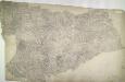
Holsworthy, Devon
Pencil annotations on the bottom right of the map give the surveyors name and the drawing's date and scale. A red dashed line denotes the border of Devon and Cornwall, running partly along the course of the River Tamer. Pencil rays intersect across the plan, evidence of triangulation measurements taken by the surveyor. Although it did not become obligatory to include archaeological details until 1816, prehistoric defensive earthworks are noted at Warbstow Barrow . A windmill is shown in elevation at Holsworthy. Budgen, Charles
Ashburton(002OSD000000001U00018000)
Draughtsmen used the colour red to indicate stone, so the unbroken red line around Huntingdon Warren in the centre of the,map means that it was enclosed by a stone wall., Field boundaries are also shown, with those in red again representing stone walls., Notably, the draughtsman has drawn pecked red lines on this map, most obviously at Yealm River in the central left area., These may have represented stone circles., Place names are truncated where the margins of the manuscript have been trimmed. Dawson, Robert
Bovey Tracey
The military impetus of the Ordnance Survey is evident in the draughtsmen's preoccupation in detailing the lie of the land, not just its topographical features. Relief is indicated here by shading and the use of short disconnected lines drawn in the direction of the slopes - a technique called hachuring. Woods are coloured green. Red crosses and dots around the outer edge of the landmass indicate observation stations, which were used to plot distinctive features of the land being surveyed. The main roads are marked at mile intervals. Hewitt, John
A coloured chart of Plymouth Harbour, and of the country up to Tavistock; drawn possibly by Robert Spry
This is a map of Plymouth and environs and is a 16th century copy of an original map dating from 1591 by Robert Spry. Spry is recorded as a painter in municipal records between 1569-70 and 1591-2. The map is drawn in a somewhat archaic pictorial style with topographical details drawn in perspective. Great detail has been observed in the depiction of churches and country houses and three beacons, the means of alerting the surrounding area, are recorded. The anchorages of the Sound are marked by drawings of ships. The map shows the conduit or leat that was constructed by Sir Francis Drake in 1590-1 in order to provide a water-supply for the town from Dartmoor. In connection with his leat, Drake had been granted a lease of the six town mills in 1583. The leat was designed for the watering of ships and to power the mills and played a central role in Drake’s hopeful project to make Plymouth a powerful naval station. Although popular local tradition suggested that Drake had employed magic in order to effect the construction of the leat which passed through "mighti rockes which was thought unpossible to carrie water through", it was in fact the work of the Plymouth engineers Robert Lampen and his brother. Figures along the course of the leat, from the River Meavy to Plymouth record miles. A section that is likely to have contained an explanatory table has been removed, resulting in the maps irregular shape. Spry, Robert
SS41 - OS 1:25,000 Provisional Series Map
1 : 25000 Topographic maps Ordnance Survey Ordnance Survey
SS40 - OS 1:25,000 Provisional Series Map
1 : 25000 Topographic maps Ordnance Survey Ordnance Survey
SS51 - OS 1:25,000 Provisional Series Map
1 : 25000 Topographic maps Ordnance Survey Ordnance Survey
SX48 - OS 1:25,000 Provisional Series Map
1 : 25000 Topographic maps Ordnance Survey Ordnance Survey
SS50 - OS 1:25,000 Provisional Series Map
1 : 25000 Topographic maps Ordnance Survey Ordnance Survey
SX47 - OS 1:25,000 Provisional Series Map
1 : 25000 Topographic maps Ordnance Survey Ordnance Survey
SS61 - OS 1:25,000 Provisional Series Map
1 : 25000 Topographic maps Ordnance Survey Ordnance Survey
SS60 - OS 1:25,000 Provisional Series Map
1 : 25000 Topographic maps Ordnance Survey Ordnance Survey
SS70 - OS 1:25,000 Provisional Series Map
1 : 25000 Topographic maps Ordnance Survey Ordnance Survey
SS71 - OS 1:25,000 Provisional Series Map
1 : 25000 Topographic maps Ordnance Survey Ordnance Survey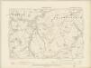
Devonshire XXIX.SW - OS Six-Inch Map
1 : 10560 Topographic maps Ordnance Survey Ordnance Survey
Devonshire XXIX.SW - OS Six-Inch Map
1 : 10560 Topographic maps Ordnance Survey Ordnance Survey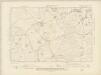
Devonshire XL.NW - OS Six-Inch Map
1 : 10560 Topographic maps Ordnance Survey Ordnance Survey