Maps of Exeter
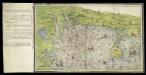
Ottermouth Haven [Coasts of Devon and Dorset from Dartmouth to Weymouth with a written description of Ottermouth Haven]
This is a map of the coast of Devon and Cornwall from Dartmouth to Weymouth which forms part of an atlas that belonged to William Cecil Lord Burghley, Secretary of State to Elizabeth I. Burghley used this atlas to illustrate domestic matters. This map shows the coastline in a pictorial fashion, with buildings indicated by generic, rather than individualized images of various building types. In the left hand margin is a written description of Ottermouth haven, which also features on the map itself. A dominating feature of the map in the compass rose in the centre which has lines radiating from it, each with a direction written along side it. From the style of the lettering and the depiction of the ships the map can be dated to the around 1540. Lord Burghley has annotated the map, adding a we’y of xviii foot brod’ to a narrow bridge of land and adding Sandfoot castle to the coastline to the right of the Isle Portland. The map may have originally been drawn in connection with the 1539-40 invasion scare caused by the alliance against England of France and Spain. The fortification of the Dorset coast was an essential part of the defensive preparations and in April 1539 Lord Russell surveyed the area, sending a plat’ to Cromwell which suggested a much more ambitious fortification program than was actually carried out. Sandfoot, which Lord Burghley has inserted onto this map, was in commission by 1541-1542. The fact that it does not originally appear on the map suggests that it was not built at the time of the maps execution. This is curious however as Portland Castle, built at the same time as Sandfoot, was included by the original draughtsman. The castles were intended to be able to cross fire over the important anchorage known as Portland Roads. Lord Burghley’s interest in the area can be attributed to a new invasion threat from Spain. This threat was also rooted in religious ideology as the Catholic Philip II of Spain wanted to remove the ardently Protestant Elizabeth I from the English Throne. Unfortunately, the coastal forts in Dorset, as with others in England, had been allowed to fall into disrepair. Finally in 1584 action to repair the Dorset forts was authorised by the Privy Council. William Cecil, Lord Burghley
Cary's Improved Map of England and Wales
Cary, George, & Cary, John London : G. & J. Cary
Exeter - OS One-Inch Map
1 : 63360 Topographic maps Ordnance Survey Ordnance Survey
Dorset Shire, 1
2 Blätter : 109 x 54 cm s.n.
Bridport
The long stretch of sand in this plan is Chesil Beach. Once linked to Spain by well- established trade routes, it is also locally famed for reported sightings of the fabled Veasta Sea Monster. Signal points are marked along coast leading down to the beach, the most notable being Abbotsbury Castle Signal Staff on Abbotsbury Common. Pencil script records the date of execution and scale of the drawing. The words "Exhibit A" are written in blue pencil at the very edge of the sheet. A reference to the village of 'Wyke' (Wyke Regis) can be seen at the far right of the drawing. Budgen, Charles
Exeter (Hills) - OS One-Inch Revised New Series
1 : 63360 Topographic maps Ordnance Survey Ordnance Survey
Exeter (Outline) - OS One-Inch Revised New Series
1 : 63360 Topographic maps Ordnance Survey Ordnance Survey
Teignmouth (Hills) - OS One-Inch Revised New Series
1 : 63360 Topographic maps Ordnance Survey Ordnance Survey
Teignmouth (Outline) - OS One-Inch Revised New Series
1 : 63360 Topographic maps Ordnance Survey Ordnance Survey
Sidmouth (Outline) - OS One-Inch Revised New Series
1 : 63360 Topographic maps Ordnance Survey Ordnance Survey
Sidmouth (Hills) - OS One-Inch Revised New Series
1 : 63360 Topographic maps Ordnance Survey Ordnance Survey
Otterton (Outline) - OS One-Inch Revised New Series
1 : 63360 Topographic maps Ordnance Survey Ordnance Survey
Otterton (Hills) - OS One-Inch Revised New Series
1 : 63360 Topographic maps Ordnance Survey Ordnance Survey
Bridport (Hills) - OS One-Inch Revised New Series
1 : 63360 Topographic maps Ordnance Survey Ordnance Survey
Bridport (Outline) - OS One-Inch Revised New Series
1 : 63360 Topographic maps Ordnance Survey Ordnance Survey
West Fleet (Hills) - OS One-Inch Revised New Series
1 : 63360 Topographic maps Ordnance Survey Ordnance Survey
West Fleet (Outline) - OS One-Inch Revised New Series
1 : 63360 Topographic maps Ordnance Survey Ordnance Survey
To the Right Honorable the Master, Wardens & Elder Brethren of the Trinity House, this Chart of Plymouth Sound is ... dedicated
1 : 26000 Heather, W. (William) Heather, W. (William)
Exmouth
This plan of the area around the mouth of the River Exe is comprised of two sheets joined together. The meticulous detail of the survey extends to recording sandbanks and details of the river bed. Relief is indicated by interlining ('hachuring') and shading. Stippling and stripes distinguish different land usage. A faint blue line with a quartered circle extending into Holcombe Down, at centre bottom, is probably an observation or measuring line. Annotations in pencil record the scale and date of the survey. At the bottom-right edge, "Part of the Ordn[ance"] is written ink. Stanley, William
Torquay (Outline) - OS One-Inch Revised New Series
1 : 63360 Topographic maps Ordnance Survey Ordnance Survey
Torquay (Hills) - OS One-Inch Revised New Series
1 : 63360 Topographic maps Ordnance Survey Ordnance Survey
Dorchester
This drawing is very worn with some areas missing. The Ordnance Survey Letter Book notes that Mr Budgen was to be at Dorchester "on a new piece of work on the 29th Day of this Month", allowing us to be fairly certain of the authorship of this drawing. Maiden Castle - at 47 acres the largest iron age hillfort in Europe - is marked in the bottom left. The lines describing it follow the actual shape of the earthworks. Budgen, Charles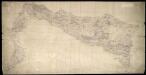
Weymouth
This drawing covers the coast of Weymouth Bay and the Isle of Portland. Lighthouses are marked on the tip of the island. Red lines denote stone walls. Sandsfoot Castle and Portland Castle are shown by blocks of red ink. These were among of a series of castles built by Henry VIII as defence against Spain and France after his divorce from the Catholic Catherine of Aragon and his breaking of ties with Rome. Chalbury Hillfort is indicated above Weymouth Bay. Archaeological sites were of interest to many of the draughtsmen and were often included even before it became obligatory to do so in 1816. The boundary with Purbeck is indicated by a red pecked line. Budgen, Charles
Weymouth (Outline) - OS One-Inch Revised New Series
1 : 63360 Topographic maps Ordnance Survey Ordnance Survey
Weymouth (Hills) - OS One-Inch Revised New Series
1 : 63360 Topographic maps Ordnance Survey Ordnance Survey
Dorchester (Hills) - OS One-Inch Revised New Series
1 : 63360 Topographic maps Ordnance Survey Ordnance Survey
Dorchester (Outline) - OS One-Inch Revised New Series
1 : 63360 Topographic maps Ordnance Survey Ordnance Survey
De reeden van Waijmouth en Poortland als ook de hoek van Poortland en van daer langs St. Andries Land tot de Peveral Punt int groot
England Gerard van Keulen
Beaminster
This drawing delineates the county borders of Dorset and Somerset with a red pecked line. Pillesdon Pen, a hillfort, is indicated by concentric rings to the left of the plan, although it did not become obligatory to record archaeological sites until 1816. The fort's position, 909 ft above sea level, is depicted by dark shading and brushwork interlining ('hachuring'). The summits of hills in this undulating countryside are left bare.
![Ottermouth Haven [Coasts of Devon and Dorset from Dartmouth to Weymouth with a written description of Ottermouth Haven]](https://images-2.georeferencer.com/images/iiif/218601718155/full/,300/0/native.jpg)

