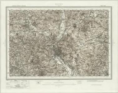
Maps of Exeter

Exeter (Hills) - OS One-Inch Revised New Series
1 : 63360 Topographic maps Ordnance Survey Ordnance Survey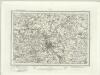
Exeter (Outline) - OS One-Inch Revised New Series
1 : 63360 Topographic maps Ordnance Survey Ordnance Survey
Exeter
This drawing covers the land either side of the Ex River. Exeter, the largest settlement, is shown in great detail. A barracks, poor house and 'New Gaol' are shown by red blocks on the outskirts of the settlement. The main road leading into Exeter is tinted yellow to indicate its status as a major communication route. A tollgate, marked 'T. Gate", appears on this road at the entrance to the town. A tributary of the Ex River features a series of locks, annotated and marked by a break in the green line that represents water. Lime Kilns are noted in the area. To the left of the drawing, above Whitstone, a dot with a pencil line radiating from it indicates a point from which the surveyor took an angular measurement to plot the path leading from the main road to Springs. Budgen, Thomas
Bickleigh
.Although it was not until 1816 that recording archaeological sites became obligatory, the draughtsman of this map has indicated an iron-age hillfort, Cadbury Castle, near the town of Cadbury. It is depicted by a rough ring at the summit of a hill. Inclines in general are indicated by dense brushwork. The River Ex is shown in green. Its left bank is drawn with a reinforced line to denote a river that was particularly wide or tidal. Budgen, Thomas
SY09 - OS 1:25,000 Provisional Series Map
1 : 25000 Topographic maps Ordnance Survey Ordnance Survey
Ottery St. Mary
Woodbury Common dominates this drawing. The uncultivated land of the common is represented by sets of dashes representing grass. Woodbury Castle is indicated by concentric irregular shapes, mirroring the shape of the prehistoric earthworks. This drawing is drawn to a scale of 3 inches to 1 mile, larger than most of the other drawings, which are 2 inches to 1 mile. The larger scale reflects the need for greater detail in areas of the south coast that were particularly vulnerable to invasion. Budgen, Thomas
Cullompton, Devon
An impression of the relative relief of the land is given here by interlined brushwork ('hachuring'). The hachuring is dense in high areas, except the summits of hills, which are left bare. Settlements are described by red blocks. One major feature of the Survey is the attention paid to the road network, an important military factor. Here pinpricks can be seen along the roads, showing that a mechanical instrument was used to plot them. Major roads are tinted yellow. Budgen, Thomas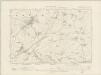
Devonshire LVII.SW - OS Six-Inch Map
1 : 10560 Topographic maps Ordnance Survey Ordnance Survey
Devonshire LVII.SW - OS Six-Inch Map
1 : 10560 Topographic maps Ordnance Survey Ordnance Survey
Devonshire LXIX.NW - OS Six-Inch Map
1 : 10560 Topographic maps Ordnance Survey Ordnance Survey
Devonshire LXIX.NW - OS Six-Inch Map
1 : 10560 Topographic maps Ordnance Survey Ordnance Survey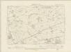
Devonshire LXIX.SW - OS Six-Inch Map
1 : 10560 Topographic maps Ordnance Survey Ordnance Survey
Devonshire LXIX.SW - OS Six-Inch Map
1 : 10560 Topographic maps Ordnance Survey Ordnance Survey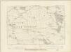
Devonshire LXXXI.NW - OS Six-Inch Map
1 : 10560 Topographic maps Ordnance Survey Ordnance Survey
Devonshire LXXXI.NW - OS Six-Inch Map
1 : 10560 Topographic maps Ordnance Survey Ordnance Survey
Devonshire LVI.SE - OS Six-Inch Map
1 : 10560 Topographic maps Ordnance Survey Ordnance Survey
Devonshire LVI.SE - OS Six-Inch Map
1 : 10560 Topographic maps Ordnance Survey Ordnance Survey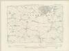
Devonshire LXXXI.SW - OS Six-Inch Map
1 : 10560 Topographic maps Ordnance Survey Ordnance Survey
Devonshire LXXXI.SW - OS Six-Inch Map
1 : 10560 Topographic maps Ordnance Survey Ordnance Survey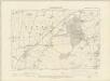
Devonshire LXVIII.NE - OS Six-Inch Map
1 : 10560 Topographic maps Ordnance Survey Ordnance Survey
Devonshire LXVIII.NE - OS Six-Inch Map
1 : 10560 Topographic maps Ordnance Survey Ordnance Survey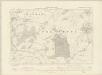
Devonshire LXVIII.SE - OS Six-Inch Map
1 : 10560 Topographic maps Ordnance Survey Ordnance Survey
Devonshire LXVIII.SE - OS Six-Inch Map
1 : 10560 Topographic maps Ordnance Survey Ordnance Survey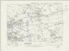
Devonshire LXXX.NE - OS Six-Inch Map
1 : 10560 Topographic maps Ordnance Survey Ordnance Survey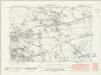
Devonshire LXXX.NE - OS Six-Inch Map
1 : 10560 Topographic maps Ordnance Survey Ordnance Survey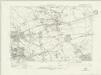
Devonshire LXXX.NE - OS Six-Inch Map
1 : 10560 Topographic maps Ordnance Survey Ordnance Survey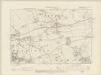
Devonshire LXXX.NE - OS Six-Inch Map
1 : 10560 Topographic maps Ordnance Survey Ordnance Survey
Devonshire LXXX.NE - OS Six-Inch Map
1 : 10560 Topographic maps Ordnance Survey Ordnance Survey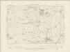
Devonshire LVI.SW - OS Six-Inch Map
1 : 10560 Topographic maps Ordnance Survey Ordnance Survey