Maps of Devon
Otterton (Outline) - OS One-Inch Revised New Series
1 : 63360 Topographic maps Ordnance Survey Ordnance Survey
Otterton (Hills) - OS One-Inch Revised New Series
1 : 63360 Topographic maps Ordnance Survey Ordnance Survey
SY18 - OS 1:25,000 Provisional Series Map
1 : 25000 Topographic maps Ordnance Survey Ordnance Survey
Devonshire XCIV.SW - OS Six-Inch Map
1 : 10560 Topographic maps Ordnance Survey Ordnance Survey
Devonshire XCIV.SW - OS Six-Inch Map
1 : 10560 Topographic maps Ordnance Survey Ordnance Survey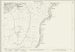
Devon XCIV.9 (includes: Otterton) - 25 Inch Map
1 : 2500 Topographic maps Ordnance Survey Ordnance Survey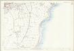
Devon XCIV.9 (includes: Otterton) - 25 Inch Map
1 : 2500 Topographic maps Ordnance Survey Ordnance Survey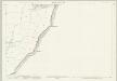
Devon XCIV.13 (includes: Otterton) - 25 Inch Map
1 : 2500 Topographic maps Ordnance Survey Ordnance Survey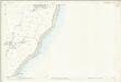
Devon XCIV.13 (includes: Otterton) - 25 Inch Map
1 : 2500 Topographic maps Ordnance Survey Ordnance Survey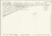
Devon CIII.4 & CIIIA.1 (includes: Budleigh Salterton; Otterton) - 25 Inch Map
1 : 2500 Topographic maps Ordnance Survey Ordnance Survey
Devon CIIIA.1 (includes: Otterton) - 25 Inch Map
1 : 2500 Topographic maps Ordnance Survey Ordnance Survey
SY28 - OS 1:25,000 Provisional Series Map
1 : 25000 Topographic maps Ordnance Survey Ordnance Survey
Ottery St. Mary, Devon
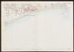
A note at the base of this drawing reads "Ordnance Survey of part of Devonshire". If this annotation was added at the time of the drawing's execution, 1807, it would be the earliest reference to the Ordnance Survey. The word 'flag' on Beacon Hill denotes a trigonometrical station, a location from which the surveyor took angular measurements to plot features of the landscape. Archaeological sites are marked by concentric shapes and dark shading at Sidbury and near Southleigh Hill. It is hard to identify these sites, however, since the dark brushwork used to denote relief renders many place names illegible. The coastline is observed in detail, showing sands, rocky outcrops and coves - a reflection of the importance of accurate surveying along the 'invasion coast'. Searle, Richard
SY39 & Parts of SY38 - OS 1:25,000 Provisional Series Map
1 : 25000 Topographic maps Ordnance Survey Ordnance Survey
SY08 & Parts of SY07 - OS 1:25,000 Provisional Series Map
1 : 25000 Topographic maps Ordnance Survey Ordnance Survey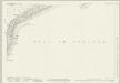
Devon XCIV.6 (includes: Otterton; Sidmouth) - 25 Inch Map
1 : 2500 Topographic maps Ordnance Survey Ordnance Survey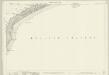
Devon XCIV.6 (includes: Otterton; Sidmouth) - 25 Inch Map
1 : 2500 Topographic maps Ordnance Survey Ordnance Survey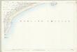
Devon XCIV.6 (includes: Otterton; Sidmouth) - 25 Inch Map
1 : 2500 Topographic maps Ordnance Survey Ordnance Survey
Devon XCIV.5 (includes: Bicton; Colaton Raleigh; Otterton) - 25 Inch Map
1 : 2500 Topographic maps Ordnance Survey Ordnance Survey
Devon XCIV.5 (includes: Bicton; Colaton Raleigh; Otterton) - 25 Inch Map
1 : 2500 Topographic maps Ordnance Survey Ordnance Survey
Devon XCIV.5 (includes: Bicton; Colaton Raleigh; Otterton) - 25 Inch Map
1 : 2500 Topographic maps Ordnance Survey Ordnance Survey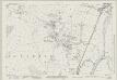
Devon XCIII.12 (includes: East Budleigh; Otterton) - 25 Inch Map
1 : 2500 Topographic maps Ordnance Survey Ordnance Survey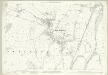
Devon XCIII.12 (includes: East Budleigh; Otterton) - 25 Inch Map
1 : 2500 Topographic maps Ordnance Survey Ordnance Survey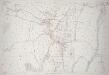
Devon XCIII.12 (includes: East Budleigh; Otterton) - 25 Inch Map
1 : 2500 Topographic maps Ordnance Survey Ordnance Survey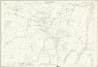
Devon XCIII.12 (includes: East Budleigh; Otterton) - 25 Inch Map
1 : 2500 Topographic maps Ordnance Survey Ordnance Survey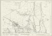
Devon XCIII.16 (includes: Budleigh Salterton; East Budleigh; Otterton) - 25 Inch Map
1 : 2500 Topographic maps Ordnance Survey Ordnance Survey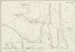
Devon XCIII.16 (includes: Budleigh Salterton; East Budleigh; Otterton) - 25 Inch Map
1 : 2500 Topographic maps Ordnance Survey Ordnance Survey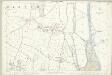
Devon XCIII.16 (includes: Budleigh Salterton; East Budleigh; Otterton) - 25 Inch Map
1 : 2500 Topographic maps Ordnance Survey Ordnance Survey
Devon CIII.4 & CIIIA.1 (includes: Budleigh Salterton; Otterton) - 25 Inch Map
1 : 2500 Topographic maps Ordnance Survey Ordnance Survey
Devon CIII.4 (includes: Budleigh Salterton; Otterton) - 25 Inch Map
1 : 2500 Topographic maps Ordnance Survey Ordnance Survey