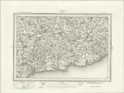
Maps of Lyme Regis
Sidmouth (Outline) - OS One-Inch Revised New Series
1 : 63360 Topographic maps Ordnance Survey Ordnance Survey
Sidmouth (Hills) - OS One-Inch Revised New Series
1 : 63360 Topographic maps Ordnance Survey Ordnance Survey
Axmouth, Devon
Dark brushwork makes much of this drawing difficult to interpret. The map covers a section of the south English coast, clearly distinguishing rocks, sand and marshland clearly. A military battery is noted at Seaton, part of the large defence system in the area. Major lines of communication are coloured yellow, following standard military cartographic convention. Searle, Robert
Ottery St. Mary, Devon
A note at the base of this drawing reads "Ordnance Survey of part of Devonshire". If this annotation was added at the time of the drawing's execution, 1807, it would be the earliest reference to the Ordnance Survey. The word 'flag' on Beacon Hill denotes a trigonometrical station, a location from which the surveyor took angular measurements to plot features of the landscape. Archaeological sites are marked by concentric shapes and dark shading at Sidbury and near Southleigh Hill. It is hard to identify these sites, however, since the dark brushwork used to denote relief renders many place names illegible. The coastline is observed in detail, showing sands, rocky outcrops and coves - a reflection of the importance of accurate surveying along the 'invasion coast'. Searle, Richard
SY19 - OS 1:25,000 Provisional Series Map
1 : 25000 Topographic maps Ordnance Survey Ordnance Survey
SY29 - OS 1:25,000 Provisional Series Map
1 : 25000 Topographic maps Ordnance Survey Ordnance Survey
Honiton
This drawing is very worn. Place names have faded considerably and are difficult to read. Two large archaeological sites are marked by concentric shapes drawn in dark lines. However, the condition of the map makes it hard to assign names to these. 'Flag', 'Staff' and 'Trig' are noted at several places, such as Upcott Penn in the top left corner. These indicate observation stations from which the surveyor took measurements in order to plot features of the landscape. Searle, Robert
Axminster
The dark brushwork used by the draughtsman to describe relief makes the place names and details of this drawing hard to read. The word 'flag' appears in several place, most clearly at Yarcombe Hill at the top of the drawing. This denotes a trigonometrical station, a location from which the surveyor took angular measurements in order to plot features of the landscape. Two ancient earthworks are marked by concentric shapes and dark shading at Stockland Hill and Membury. A yellow pecked line indicates the boundary between Devon and Dorset. Searle, Richard
Devonshire LX.SW - OS Six-Inch Map
1 : 10560 Topographic maps Ordnance Survey Ordnance Survey
Devonshire LX.SW - OS Six-Inch Map
1 : 10560 Topographic maps Ordnance Survey Ordnance Survey
Devonshire LXXII.NW - OS Six-Inch Map
1 : 10560 Topographic maps Ordnance Survey Ordnance Survey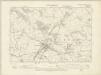
Devonshire LXXII.NW - OS Six-Inch Map
1 : 10560 Topographic maps Ordnance Survey Ordnance Survey
Devonshire LXXII.NW - OS Six-Inch Map
1 : 10560 Topographic maps Ordnance Survey Ordnance Survey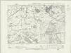
Devonshire LXXII.SW - OS Six-Inch Map
1 : 10560 Topographic maps Ordnance Survey Ordnance Survey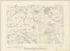
Devonshire LXXII.SW - OS Six-Inch Map
1 : 10560 Topographic maps Ordnance Survey Ordnance Survey
Devonshire LXXII.SW - OS Six-Inch Map
1 : 10560 Topographic maps Ordnance Survey Ordnance Survey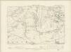
Devonshire LXXXIV.NW - OS Six-Inch Map
1 : 10560 Topographic maps Ordnance Survey Ordnance Survey
Devonshire LXXXIV.NW - OS Six-Inch Map
1 : 10560 Topographic maps Ordnance Survey Ordnance Survey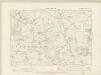
Devonshire LIX.SE - OS Six-Inch Map
1 : 10560 Topographic maps Ordnance Survey Ordnance Survey
Devonshire LIX.SE - OS Six-Inch Map
1 : 10560 Topographic maps Ordnance Survey Ordnance Survey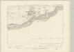
Devonshire LXXXIV.SW - OS Six-Inch Map
1 : 10560 Topographic maps Ordnance Survey Ordnance Survey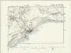
Devonshire LXXXIV.SW - OS Six-Inch Map
1 : 10560 Topographic maps Ordnance Survey Ordnance Survey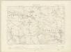
Devonshire LXXI.NE - OS Six-Inch Map
1 : 10560 Topographic maps Ordnance Survey Ordnance Survey
Devonshire LXXI.NE - OS Six-Inch Map
1 : 10560 Topographic maps Ordnance Survey Ordnance Survey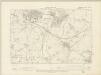
Devonshire LXXI.SE - OS Six-Inch Map
1 : 10560 Topographic maps Ordnance Survey Ordnance Survey
Devonshire LXXI.SE - OS Six-Inch Map
1 : 10560 Topographic maps Ordnance Survey Ordnance Survey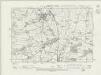
Devonshire LXXXIII.NE - OS Six-Inch Map
1 : 10560 Topographic maps Ordnance Survey Ordnance Survey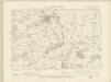
Devonshire LXXXIII.NE - OS Six-Inch Map
1 : 10560 Topographic maps Ordnance Survey Ordnance Survey
Devonshire LXXXIII.NE - OS Six-Inch Map
1 : 10560 Topographic maps Ordnance Survey Ordnance Survey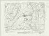
Devonshire LIX.SW - OS Six-Inch Map
1 : 10560 Topographic maps Ordnance Survey Ordnance Survey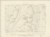
Devonshire LIX.SW - OS Six-Inch Map
1 : 10560 Topographic maps Ordnance Survey Ordnance Survey