Maps of Dobwalls and Trewidland

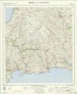
Bodmin and Launceston - OS One-Inch Map
1 : 63360 Topographic maps Ordnance Survey Ordnance Survey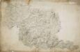
Bodmin, Cornwall
Bodmin Moor features on this drawing. The relative relief of the land is indicated by a combination of shading, brushwork interlining ('hachuring') and trigonometrical altitudes noted at the summit of inclines. Tin and copper mines are indicated by different symbols, and archaeological sites are shown by various yellow-tinted circular formations. The drawing spans three conjoined sheets. The 'Ordnance Office Copy' blind stamp can be seen in the top left corner. Dawson, Robert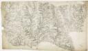
Liskeard, Cornwall
This drawing is mentioned in the Ordnance Survey Letter Book. Folio 91 records that the drawing was returned to the Tower from the Quartermaster General's Office. The circular hole in the top right-hand corner indicates that an 'Ordnance Office Copy' blind stamp has been removed. Relief is a dominant feature of this drawing, recorded by shading and interlining ('hachuring'). Trigonometrical altitudes are also recorded. Coniferous and deciduous trees are distinguished pictorially. Although recording archaeological sites was not obligatory until 1816, many draughtsmen noted these prior to this. Here an 'Ancient Fort' is shown in Trelawn, while an ancient earth bank called Giant's Hedge, possibly the boundary of a petty kingdom, is marked by a yellow line. Dawson, Robert
South Petherwin, Cornwall
A triangulation diagram covers this whole drawing. This was used to plot the location of significant features around which other topographical details could be added., Trigonometric altitudes are recorded at the summit of inclines, while short disconnected lines are drawn in blue watercolour to represent relief - a technique known as 'hachuring'.,Several archaeological sites are recorded on this drawing, although this did not become obligatory until 1816.,In the lower section of the map to the left of Upton, a darkened triangular point is marked,'Cheese Wring'.,Below this is a stone circle named 'The Hurlers'.,Field boundaries are marked, with darker lines indicating the division between cultivated and uncultivated land.,A table of figures appears in pencil,to the lower right of the drawing.,Sealing wax is apparent on the reverse.,The paper is watermarked W. ELGAR 1796., Dawson, Robert
Fowey, Cornwall
This map features surveyor Robert Dawson's distinctive contouring technique: soft brushwork interlining ('hachuring') combined with numerical notation of relative relief. Dawson has detailed hillforts, medieval castles, barrows and antiquities, including Helmen Tor and St. Prideaux in the north and Fowey Castle and St. Saviours Tower in the south. A coniferous tree plantation is indicated to the right of the moated mound surrounding Restormel Castle, towards the top right of the map. Built by the Normans, the castle had superb defences and was only successfully invaded once in its long history, when Charles I's forces drove out the Parliamentarian garrison in 1644 during the English Civil War. .This map is dated 1805 in pencil on the bottom right-hand corner. Below this, a note of the scale in ink was partly cut off when the margins were trimmed. Dawson, Robert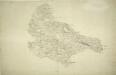
Launceston, Cornwall 1
Once the capital of Cornwall, Launceston is represented here by red blocks, each indicating a stone building., The castle dates from Norman times and was one of the greatest strongholds of the Earls of Cornwall, controlling the main entry route into the county., The road leading to Trevadlack Cross is physically,marked on the map,by a series of pin-holes., This means the draughtsman used measuring dividers to plot the exact course of the road., Recording archaeological sites did not become obligatory until 1816, but,many draughtsmen included them before then,out of personal interest., Here,,a set of concentric circles at the top of the map represents such a site, called,'Giant's Grave'., Hewitt, John
Camelford, Cornwall (002OSD000000001U00009000)
Royal Military Draughtsmen and Surveyors were listed as first-class or second-class by the Tower of London Drawing Room according to the quality of their work. Robert Dawson, the draughtsman of this map, was an influential teacher at the Tower and rated first-class, while Henry Stevens, the surveyor, was rated only second-class.The orientation of this map does not have north at the top. Hence, the coastal boundary from Widemouth Bay south to Tintagel Castle runs from left to right along the bottom of the drawing. A faded blue-green wash indicates water. Brown Willy, the highest point in Cornwall, is shown on the northern edge of Bodmin Moor to the top right of the inland boundary. A turnpike road, coloured ochre yellow, runs from Launceston to Camelford. One side of the road is thickened and miles appear alongside in figures. The close attention given to communication routes highlights the military intent of these studies. At the same time, archaeological features and antiquities are also noted, reflecting the particular interests of individual surveyors or draughtsmen. In this instance, manganese mines are marked. Stevens, Henry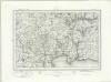
Bodmin (Outline) - OS One-Inch Revised New Series
1 : 63360 Topographic maps Ordnance Survey Ordnance Survey
Bodmin (Hills) - OS One-Inch Revised New Series
1 : 63360 Topographic maps Ordnance Survey Ordnance Survey
Tavistock (Hills) - OS One-Inch Revised New Series
1 : 63360 Topographic maps Ordnance Survey Ordnance Survey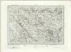
Tavistock (Outline) - OS One-Inch Revised New Series
1 : 63360 Topographic maps Ordnance Survey Ordnance Survey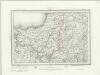
Camelford (Outline) - OS One-Inch Revised New Series
1 : 63360 Topographic maps Ordnance Survey Ordnance Survey
Camelford (Hills) - OS One-Inch Revised New Series
1 : 63360 Topographic maps Ordnance Survey Ordnance Survey
Plymouth (Hills) - OS One-Inch Revised New Series
1 : 63360 Topographic maps Ordnance Survey Ordnance Survey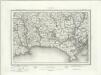
Plymouth (Outline) - OS One-Inch Revised New Series
1 : 63360 Topographic maps Ordnance Survey Ordnance Survey
Camelford, Cornwall (002OSD000000001U00010000)
This unfinished drawing shows only a skeleton outline of un-marked roads and rivers.
Callington, Cornwall
.Draughtsmen sometimes had to fit the area they were mapping on to an irregular shaped sheet of paper by changing its orientation. This is why this plan is not oriented northwards and Dunterton appears to the far right of Callington rather than above it. The Meridian of Kitt Hill is marked along the base of the drawing with Kit Hill Beacon as the centre point. Relief is indicated by grey brushwork and trigonometrical altitudes marked in red. The accuracy with which the Ordnance Survey drawings indicate relief set them apart from the earlier county maps and qualified them for military use. Holberton, R. R.
SX08 & Parts of SX09 - OS 1:25,000 Provisional Series Map
1 : 25000 Topographic maps Ordnance Survey Ordnance Survey
SX07 - OS 1:25,000 Provisional Series Map
1 : 25000 Topographic maps Ordnance Survey Ordnance Survey
SX18 - OS 1:25,000 Provisional Series Map
1 : 25000 Topographic maps Ordnance Survey Ordnance Survey
SX06 - OS 1:25,000 Provisional Series Map
1 : 25000 Topographic maps Ordnance Survey Ordnance Survey
SX17 - OS 1:25,000 Provisional Series Map
1 : 25000 Topographic maps Ordnance Survey Ordnance Survey
SX05 - OS 1:25,000 Provisional Series Map
1 : 25000 Topographic maps Ordnance Survey Ordnance Survey
SX28 - OS 1:25,000 Provisional Series Map
1 : 25000 Topographic maps Ordnance Survey Ordnance Survey
SX16 - OS 1:25,000 Provisional Series Map
1 : 25000 Topographic maps Ordnance Survey Ordnance Survey
SX27 - OS 1:25,000 Provisional Series Map
1 : 25000 Topographic maps Ordnance Survey Ordnance Survey
SX26 - OS 1:25,000 Provisional Series Map
1 : 25000 Topographic maps Ordnance Survey Ordnance Survey
SX38 - OS 1:25,000 Provisional Series Map
1 : 25000 Topographic maps Ordnance Survey Ordnance Survey
SX15 & Parts of SX14 - OS 1:25,000 Provisional Series Map
1 : 25000 Topographic maps Ordnance Survey Ordnance Survey