Maps of Cornwall

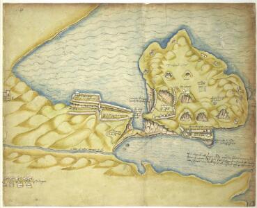
A Coloured Plan, or Bird's Eye View of "Tindegal Island" or Tintagel Castle, near Bossiney, on the North Coast of Cornwall
This plan is something of a mystery. It seems to be Tintagel, near Bossiney, Cornawall, labelling the land Tindagell Island, and the style of the drawing suggests it is contemporary with the reign of Henry VIII. However the writing is in Elizabethan secretary or italic. What is more puzzling is that there are no records to show that any work took place at Tintagel or its immediately adjacent land. The drawing shows a series of defensive walls along the edge of the coast. Facing the bay is a wall with two gun towers which the draughtsman has drawn in action.
Cornwall X.SW - OS Six-Inch Map
1 : 10560 Topographic maps Ordnance Survey Ordnance Survey
Cornwall X.SW - OS Six-Inch Map
1 : 10560 Topographic maps Ordnance Survey Ordnance Survey
Cornwall X.13 (includes: Tintagel) - 25 Inch Map
1 : 2500 Topographic maps Ordnance Survey Ordnance Survey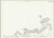
Cornwall X.9 (includes: Tintagel) - 25 Inch Map
1 : 2500 Topographic maps Ordnance Survey Ordnance Survey
Cornwall X.9 (includes: Tintagel) - 25 Inch Map
1 : 2500 Topographic maps Ordnance Survey Ordnance Survey
SX08 & Parts of SX09 - OS 1:25,000 Provisional Series Map
1 : 25000 Topographic maps Ordnance Survey Ordnance Survey
Camelford, Cornwall (002OSD000000001U00010000)
This unfinished drawing shows only a skeleton outline of un-marked roads and rivers.
Boscastle (Hills) - OS One-Inch Revised New Series
1 : 63360 Topographic maps Ordnance Survey Ordnance Survey
Boscastle (Outline) - OS One-Inch Revised New Series
1 : 63360 Topographic maps Ordnance Survey Ordnance Survey
Camelford, Cornwall (002OSD000000001U00009000)
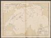
Royal Military Draughtsmen and Surveyors were listed as first-class or second-class by the Tower of London Drawing Room according to the quality of their work. Robert Dawson, the draughtsman of this map, was an influential teacher at the Tower and rated first-class, while Henry Stevens, the surveyor, was rated only second-class.The orientation of this map does not have north at the top. Hence, the coastal boundary from Widemouth Bay south to Tintagel Castle runs from left to right along the bottom of the drawing. A faded blue-green wash indicates water. Brown Willy, the highest point in Cornwall, is shown on the northern edge of Bodmin Moor to the top right of the inland boundary. A turnpike road, coloured ochre yellow, runs from Launceston to Camelford. One side of the road is thickened and miles appear alongside in figures. The close attention given to communication routes highlights the military intent of these studies. At the same time, archaeological features and antiquities are also noted, reflecting the particular interests of individual surveyors or draughtsmen. In this instance, manganese mines are marked. Stevens, Henry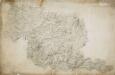
Bodmin, Cornwall
Bodmin Moor features on this drawing. The relative relief of the land is indicated by a combination of shading, brushwork interlining ('hachuring') and trigonometrical altitudes noted at the summit of inclines. Tin and copper mines are indicated by different symbols, and archaeological sites are shown by various yellow-tinted circular formations. The drawing spans three conjoined sheets. The 'Ordnance Office Copy' blind stamp can be seen in the top left corner. Dawson, Robert
Bodmin and Launceston - OS One-Inch Map
1 : 63360 Topographic maps Ordnance Survey Ordnance Survey
Newquay and Padstow - OS One-Inch Map
1 : 63360 Topographic maps Ordnance Survey Ordnance Survey
Bude - OS One-Inch Map
1 : 63360 Topographic maps Ordnance Survey Ordnance Survey
Sheets 11-12. (Cary's England, Wales, and Scotland).
1 : 360000 Cary, John, ca. 1754-1835
DEVONIAE COMITAT
This map of Devon is from the 1583 edition of the Saxton atlas of England and Wales. This atlas was first published as a whole in 1579. It consists of 35 coloured maps depicting the counties of England and Wales. The atlas is of great significance to British cartography as it set a standard of cartographic representation in Britain and the maps remained the basis for English county mapping, with few exceptions, until after 1750. During the reign of Elizabeth I map use became more common, with many government matters referring to increasingly accurate maps with consistent scales and symbols, made possible by advances in surveying techniques. Illustrating the increasing used of maps in government matters, Lord Burghley, Elizabeth I’s Secretary of State, who had been determined to have England and Wales mapped in detail from the 1550s, selected the cartographer Christopher Saxton to produce a detailed and consistent survey of the country. The financier of the project was Thomas Seckford Master of Requests at the Court of Elizabeth I, whose arms appear, along with the royal crest, on each map. The decorative scale bar houses the name of Saxton and of the Flemish engraver Remigius Hogenberg who prepared the copper plate for this map. This is the only map in the atlas that features a compass rose as well as the cardinal points in the borders, seeming to indicate the Devon has been turned slightly clockwise to fit the plate. Two ships engaging in battle are depicted off the coast of Plymouth, perhaps making reference to the vulnerability of this section of south coast and the location of naval bases. Saxton, Christopher Ryther, Augustine
DEVONIAE COMOTAT
This map of Devon is by Christopher Saxton and dates from 1575. It forms part of an atlas that belonged to William Cecil Lord Burghley, Secretary of State to Elizabeth I. Burghley used this atlas to illustrate domestic matters. This map is actually a proof copy of one which forms part of Christopher Saxton’s Atlas of England and Wales. This atlas was first published as a whole in 1579. It consists of 35 coloured maps depicting the counties of England and Wales. The atlas is of great significance to British cartography as it set a standard of cartographic representation in Britain and the maps remained the basis for English county mapping, with few exceptions, until after 1750. During the reign of Elizabeth I map use became more common, with many government matters referring to increasingly accurate maps with consistent scales and symbols, made possible by advances in surveying techniques. This map was produced under the patronage of Thomas Seckford, a Master of Requests to Elizabeth I, who had commissioned Saxton’s atlas of county maps, a project overseen by Lord Burghley, Secretary of State, whose administration increasingly involved the use of maps. This map is interesting as there are several notes in the margins. In the lower right hand margin: 'A Note of hir maties Store of Ordonnaunce, powder and match, lead,&c.,remayningin ye L. Lieutenauntes, &c. hands'. In the upper right hand margin 'A Note what powder and match was appointed to be kept in store in every corporate towne'. In the left hand margin 'A Breef Note of ye places of Descent. . . yt are most daungerous and require greatest regard and assistaunce'. These annotations were most probably made by an assistant of Lord Burghley’s, and show the concern felt about coastal areas in the face of the threat from Spain which culminated in 1588 with the events of the Spanish Armada. Saxton, Christopher Hogenbergius, Remigius
Cornvbia sive Cornwallia
1 Karte : Kupferdruck ; 38 x 48 cm Blaeu Joan Blaeu
DEVONIA | vulgo | DEVON-SHIRE.
[Amsterdam : Joan Blaeu]
Cornubia sive Cornwallia
1 : 170000 Amstelodami : excudebat Ioannes Ianssonius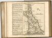

CORNVBIA | sive | CORNWALLIA.
[Amsterdam : Joan Blaeu]
PROMONTORIUM HOC IN MARE PROYECTUM CORNUBIA DICITUR Sheet 5
This map of Cornwall is from the 1583 edition of the Saxton atlas of England and Wales.This atlas was first published as a whole in 1579. It consists of 35 coloured maps depicting the counties of England and Wales. The atlas is of great significance to British cartography as it set a standard of cartographic representation in Britain and the maps remained the basis for English county mapping, with few exceptions, until after 1750. During the reign of Elizabeth I map use became more common, with many government matters referring to increasingly accurate maps with consistent scales and symbols, made possible by advances in surveying techniques. Illustrating the increasing used of maps in government matters, Lord Burghley, Elizabeth I’s Secretary of State, who had been determined to have England and Wales mapped in detail from the 1550s, selected the cartographer Christopher Saxton to produce a detailed and consistent survey of the country. The financier of the project was Thomas Seckford Master of Requests at the Court of Elizabeth I, whose arms appear, along with the royal crest, on each map. Saxton, Christopher Ryther, Augustine
PROMONTORIUM HOC IN MARE PROYECTUM CORNUBIA DICITUR f.8
This map of Cornwall is by Christopher Saxton. It forms part of an atlas that belonged to William Cecil Lord Burghley, Elizabeth I’s Secretary of State. Burghley used this atlas to illustrate domestic matters. This map is actually a proof copy of one which forms part of Christopher Saxton’s Atlas of England and Wales. This atlas was first published as a whole in 1579. It consists of 35 coloured maps depicting the counties of England and Wales. The atlas is of great significance to British cartography as it set a standard of cartographic representation in Britain and the maps remained the basis for English county mapping, with few exceptions, until after 1750. During the reign of Elizabeth I, map use became more common, with many government matters referring to increasingly accurate maps with consistent scales and symbols, made possible by advances in surveying techniques. This map was produced under the patronage of Thomas Seckford, a Master of Requests to Elizabeth I, who had commissioned Saxton’s atlas of county maps, a project overseen by Lord Burghley, Secretary of State, whose administration increasingly involved the use of maps. Here an annotation, probably by Lord Burghley, can be seen in the addition of a bridge at Truro. Such an addition is typical of Lord Burghley who was concerned with communication routes, such as roads and bridges, which were vital to the defence of the country, a central consideration during the reign of Elizabeth I, during which England was continually under threat. Saxton, Christopher Antver, Lenaert Terwoort
Devoniae Descriptio. The Description of Devon-Shire [Karte], in: Novus atlas absolutissimus, Bd. 7, S. 199.
1 Karte aus Atlas Janssonius Offizin
Devonia vulgo Devon-Shire. [Karte], in: Le théâtre du monde, ou, Nouvel atlas contenant les chartes et descriptions de tous les païs de la terre, Bd. 4, S. 120.
1 Karte aus Atlas Blaeu, Willem Janszoon und Blaeu, Joan Blaeu, Willem Janszoon
Devonia Vulgo Devon-Shire. [Karte], in: Theatrum orbis terrarum, sive, Atlas novus, Bd. 4, S. 136.
1 Karte aus Atlas Blaeu, Joan Blaeu, Willem Janszoon
Devonia Vulgo Devon-Shire. [Karte], in: Theatrum orbis terrarum, sive, Atlas novus, Bd. 4, S. 136.
1 Karte aus Atlas Blaeu, Joan Blaeu, Willem Janszoon