Maps of Camelford

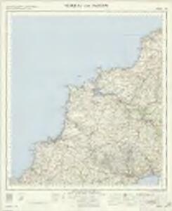
Newquay and Padstow - OS One-Inch Map
1 : 63360 Topographic maps Ordnance Survey Ordnance Survey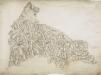
St. Columb Major, Cornwall
1 : 31680 .This drawing is orientated toward the south-east. On its reverse, obscured by backing material, is a triangulation diagram used to plot locations accurately. Tin and copper mines are marked, and a key to the symbols used to distinguish them is given at the bottom of the drawing. ."Harmony Cot" is marked as the birthplace of the portrait painter, John Opie (1761-1807). The inclusion of such information seems at odds with the Survey's military emphasis, but it does reflect the interests and training of the draughtsmen, many of whom were professional artists. To the north of St Columb Major lies the ancient monument known as the Nine Maidens, symbolised by a drawing of stones. A dot, annotated "point", appears in the bottom left hand corner of the map. This is probably the coastal station at Trevose Head, a base for the measurement of angles of elevation. Dawson, Robert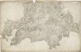
Grampound, Cornwall
1 : 31680 Military batteries are marked along the coastline in this drawing. The profusion of defensive castles in this area is testimony to the perceived vulnerability of coastal regions. Red blocks indicate individual structures within the complex of Pendennis Castle, built by Henry VIII after his divorce from Catherine of Aragon aroused the hostility of Catholic France and Spain. The nearby castle of St Mawes acted as a seaward deterrent, protecting the anchorage of Falmouth. Half Moon Battery is indicated, as are signal seats along the extreme edge of the coast. Budgen, Charles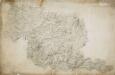
Bodmin, Cornwall
Bodmin Moor features on this drawing. The relative relief of the land is indicated by a combination of shading, brushwork interlining ('hachuring') and trigonometrical altitudes noted at the summit of inclines. Tin and copper mines are indicated by different symbols, and archaeological sites are shown by various yellow-tinted circular formations. The drawing spans three conjoined sheets. The 'Ordnance Office Copy' blind stamp can be seen in the top left corner. Dawson, Robert
Padstow, Cornwall
This drawing shows three separate landmasses on the north coast of Cornwall. The area comprising Trevose Head and the estuary of the River Camel at Padstow is drawn at a scale of 2 inches to the mile, as is the inland region south of Tredinnick and Saint Breok Downs to Roche. The area from Hensbarrow Downs to Luxulyan and Saint Blazey is depicted at the larger scale of 3 inches to the mile. The drawing is attributed to Robert Dawson (1771-1860) who represented relief by shading in short disconnected lines drawn in the direction of the slopes - a technique known as hachuring. Dawson also estimated altitudes in pencil, depicting highpoints of almost 20 metres at Saint Breok Downs. Pencil intersections spread from the upper-left landmass, indicating lines between fixed points used for triangulation. Dirt marks remain where the map was formerly folded in four. Plans were not stored flat between deal boards until the1820s. Dawson, Robert
Newquay (Hills) - OS One-Inch Revised New Series
1 : 63360 Topographic maps Ordnance Survey Ordnance Survey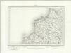
Newquay (Outline) - OS One-Inch Revised New Series
1 : 63360 Topographic maps Ordnance Survey Ordnance Survey
Trevose Head (Hills) - OS One-Inch Revised New Series
1 : 63360 Topographic maps Ordnance Survey Ordnance Survey
Trevose Head (Outline) - OS One-Inch Revised New Series
1 : 63360 Topographic maps Ordnance Survey Ordnance Survey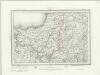
Camelford (Outline) - OS One-Inch Revised New Series
1 : 63360 Topographic maps Ordnance Survey Ordnance Survey
Camelford (Hills) - OS One-Inch Revised New Series
1 : 63360 Topographic maps Ordnance Survey Ordnance Survey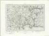
Bodmin (Outline) - OS One-Inch Revised New Series
1 : 63360 Topographic maps Ordnance Survey Ordnance Survey
Bodmin (Hills) - OS One-Inch Revised New Series
1 : 63360 Topographic maps Ordnance Survey Ordnance Survey
Fowey, Cornwall
This map features surveyor Robert Dawson's distinctive contouring technique: soft brushwork interlining ('hachuring') combined with numerical notation of relative relief. Dawson has detailed hillforts, medieval castles, barrows and antiquities, including Helmen Tor and St. Prideaux in the north and Fowey Castle and St. Saviours Tower in the south. A coniferous tree plantation is indicated to the right of the moated mound surrounding Restormel Castle, towards the top right of the map. Built by the Normans, the castle had superb defences and was only successfully invaded once in its long history, when Charles I's forces drove out the Parliamentarian garrison in 1644 during the English Civil War. .This map is dated 1805 in pencil on the bottom right-hand corner. Below this, a note of the scale in ink was partly cut off when the margins were trimmed. Dawson, Robert
SW86 & Parts of SW76 - OS 1:25,000 Provisional Series Map
1 : 25000 Topographic maps Ordnance Survey Ordnance Survey
SW87 - OS 1:25,000 Provisional Series Map
1 : 25000 Topographic maps Ordnance Survey Ordnance Survey
SW97 & Parts of SW98 - OS 1:25,000 Provisional Series Map
1 : 25000 Topographic maps Ordnance Survey Ordnance Survey
SW85 - OS 1:25,000 Provisional Series Map
1 : 25000 Topographic maps Ordnance Survey Ordnance Survey
SX08 & Parts of SX09 - OS 1:25,000 Provisional Series Map
1 : 25000 Topographic maps Ordnance Survey Ordnance Survey
SW96 - OS 1:25,000 Provisional Series Map
1 : 25000 Topographic maps Ordnance Survey Ordnance Survey
SX07 - OS 1:25,000 Provisional Series Map
1 : 25000 Topographic maps Ordnance Survey Ordnance Survey
SW95 - OS 1:25,000 Provisional Series Map
1 : 25000 Topographic maps Ordnance Survey Ordnance Survey
SX06 - OS 1:25,000 Provisional Series Map
1 : 25000 Topographic maps Ordnance Survey Ordnance Survey
SX05 - OS 1:25,000 Provisional Series Map
1 : 25000 Topographic maps Ordnance Survey Ordnance Survey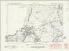
Cornwall XLVII.NE & XLVIII.NW - OS Six-Inch Map
1 : 10560 Topographic maps Ordnance Survey Ordnance Survey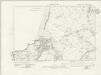
Cornwall XLVII.NE & XLVIII.NW - OS Six-Inch Map
1 : 10560 Topographic maps Ordnance Survey Ordnance Survey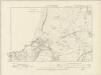
Cornwall XLVII.NE & XLVIII.NW - OS Six-Inch Map
1 : 10560 Topographic maps Ordnance Survey Ordnance Survey
Cornwall XLVII.NE & XLVIII.NW - OS Six-Inch Map
1 : 10560 Topographic maps Ordnance Survey Ordnance Survey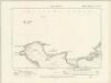
Cornwall XVIIIA.SE & XVIII.SW - OS Six-Inch Map
1 : 10560 Topographic maps Ordnance Survey Ordnance Survey