Maps of Maryland

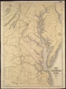
Map of part of Virginia, Maryland and Delaware from the best authorities
1 : 400000 Heyne, Charles E. & G.W. Blunt (Firm)
Strategic War Points of the United States no.3: the country round the Chesapeake and the Potomac to Washington
Strategic War points of the United States no.3: the country round the Chesapeake and the Potomac to Washington J. Wyld
NOVA VIRGINIÆ TABVLA
DGrijp Sculpt [Amsterdam : Joan Blaeu]
Strategic war points of the United States

Strategic War Points of the United States no.1: the country round Washington, the Chesapeake and the Potomac
Strategic War Points of the United States no.1: the country round Washington, the Chesapeake and the Potomac. J. Wyld
Map Of The Seat Of War.
1 : 633600 Monk, Jacob
A map of Virginia and Maryland
1 : 1150000 Speed, John Basset, Thomas
Maryland.
1 : 1774080 Scott, Joseph
The new war map of Virginia, Maryland & Pennsylvania
1 : 510000 Russel, B.B. (Benjamin B.)
Virginia / discovered and described by Captayn John Smith, 1606.
from Charts and maps
Map to illustrate the 1862 (Virginia) Campaign
Map to illustrate the 1862 (Virginia) Campaign. Map to illustrate the American Civil War of sixty years previously. This small map details the areas of Virginia around the capitals of Washington, D.C. and Richmond where a great amount of fighting took place in 1862 and indeed across the war period. Several places on the map, such as Fredericksburg, Petersburg and Manassas Junction/Bull Run witnessed heavy clashes during the conflict. The map also details railway routes in the region. War Office
Der amerikanische Kriegsschauplatz zwischen Washington und Richmond
1 : 1000000 Richmond (Virginie) Petermann, August Debes, Ernst Justus Perthes
A map of Virginia : formed from actual surveys, and the latest as well as most accurate observations / by James Madison, D.D., president of Wm. & Mary College. ; drawn by Wm. Davis ; engraved by Fred. Bossler, Richmd.
From Charts and maps
A Chart of the Chesapeake And Delaware Bays
1 : 354816 Lucas, Fielding Jr.
A map of Virginia : formed from actual surveys and the latest as well as the most accurate observations / by James Madison ; drawn by Wm. Davis ; with extensive additions and corrections to the year 1818.
from Charts and maps
Military Portraits.
1 : 950400 Waters & Son
A Chart of the Chesapeake And Delaware Bays.
1 : 354816 Lucas, Fielding Jr.
Bird's-eye view of the Seat of War
Bird's-eye view of the Seat of War, arranged after the latest Surveys. This Bird’s Eye View of the Seat of War, published by Prang, displays the region around the Chesapeake Bay and Potomac River, showing Washington, D.C., Baltimore, Harper’s Ferry, Richmond, Manassas Junction (Bull Run), Fort Monroe and Norfolk Harbour. The map also details railroad lines. It is possible to see a drawing of the Capitol building where Washington, D.C. is labelled. L. Prang & Co.
Gen. map II.
1 : 633600 United States. War Department
Seat of War in America
Seat of War in America. Published by Bacon & Co. in London, Seat of the War in America shows the region between Baltimore and Petersburg and the placement of troops and fortifications along the border between the Confederacy and the Union. It is notable how many batteries are placed around the Confederate capital of Richmond, as well as marking out the railway lines that connected the region. At the top of the map are publishing adverts for Colton productions, as well as a list of the Union and Confederate generals and a table detailing export amounts in 1860, with cotton being the largest figure. Bacon & Co.
The states of Maryland and Delaware, from the latest surveys
1 : 800000 Wayland, Reid & Smith
Maryland and Delaware.; The cerographic atlas of the United States. By Sidney E. Morse, A.M., and Samuel Breese, A.M.
from Supplement to the New York observer. Morse, Sidney E. (Sidney Edwards); Breese, Samuel,
States of Maryland and Delaware.
1 : 800000 Winterbotham, W.
Maryland, Delaware.
1 : 1300000 Cram, George Franklin; Davis, Ellis Arthur
Composite: New Map Of The Peninsula Embracing Delaware And The Eastern Shores Of Maryland And Virginia
1 : 346480 MacCormac, Walter S.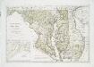
Maryland und Delaware / entworfen von D.F. Sotzmann ; W. Sander, sculp.
from Charts and maps
Maryland.
1 : 1380000 Tanner, Henry S.
War Telegram Marking Map.
1 : 490000 Prang, L. & Co.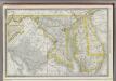
Maryland.
1 : 720000 Rand McNally and Company