Maps of Maryland

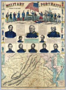
Military Portraits.
1 : 950400 Waters & Son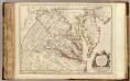
Virginie, Maryland.
1 : 870000 Robert de Vaugondy, Gilles, 1688-1766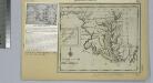
Maryland.
from Maryland
Map to illustrate the 1862 (Virginia) Campaign
Map to illustrate the 1862 (Virginia) Campaign. Map to illustrate the American Civil War of sixty years previously. This small map details the areas of Virginia around the capitals of Washington, D.C. and Richmond where a great amount of fighting took place in 1862 and indeed across the war period. Several places on the map, such as Fredericksburg, Petersburg and Manassas Junction/Bull Run witnessed heavy clashes during the conflict. The map also details railway routes in the region. War Office
Virginia and Maryland
1 : 1500000 Maryland Heřman, Augustin Faithorne, Henry Aug. Herman and Thomas Withinbrook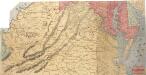
Lloyd's Military Campaign Charts: Virginia
Lloyd's Military Campaign Charts, showing the principal places of interest, compiled from official data by Gen. E.L. Viele and C. Haskins. Published under the auspices of the American Geographical and Statistical Society. Virginia.
Strategic War Points of the United States no.1: the country round Washington, the Chesapeake and the Potomac
Strategic War Points of the United States no.1: the country round Washington, the Chesapeake and the Potomac. J. Wyld
A new map of Maryland and Delaware : with their canals, roads & distances / by H.S. Tanner ; E. Gillingham, sc.
from Parts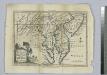
A map of Maryland with the Delaware counties and the southern part of New Jersey &c. / by T. Kitchin, geogr.
from Charts and maps Thomas Kitchin,
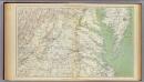
Virginia.
1 : 1700000 Cram, George Franklin; Davis, Ellis Arthur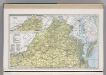
Virginia.
1 : 1271000 Hammond, C.S.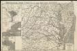
Strategic war points of the United States
Gen. map II.
1 : 633600 United States. War Department
Shell Highway Map of Delaware - Maryland, Virginia, W. Virginia. (western portion).
1 : 950400 Shell Oil Company
Neueste Karte von Maryland und Delaware mit seinen Canaelen, Strassen und Entfernungen der Hauptpunkte
Grosser Hand-Atlas über alle Theile der Erde in 170 Karten Meyer, J. Verlag des Bibliographischen Instituts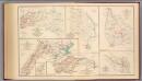
2d Corps A.N. Va., camps, pickets, routes.
Hotchkiss, Jed.
War telegram marking map
1 : 490000 L. Prang & Co Lith. of J. Bien
Der amerikanische Kriegsschauplatz zwischen Washington und Richmond
1 : 1000000 Richmond (Virginie) Petermann, August Debes, Ernst Justus Perthes
Carte de la Virginie et du Maryland dressée sur la grande carte angloise de Mrs. Josué Fry et Pierre Jefferson, / par le Sr. Robert de Vaugondy, géographe; Groux.
from John H. Levine Collection Robert de Vaugondy; Mrs. Josué Fry et Pierre Jefferson,
War Telegram Marking Map.
War Telegram Marking Map. Produced by Prang in 1862, this War Telegram Marking Map was published for sale with the intension that telegraph communications within what the map calls ‘Virginia Territory’, the area running from Baltimore to Petersburg across the Union and Confederate line, would me marked down. The explanation key on the map comments that red and blue pencils would be provided alongside the map so that Union telegraph communications could be marked in red and Confederate communications in blue. This map is unmarked. L. Prang & Co.
One Hundred & Fifty Miles Around Richmond.
1 : 887040 Magnus, Charles
The new war map of Virginia, Maryland & Pennsylvania
1 : 510000 Russel, B.B. (Benjamin B.)
Karte des Kriegs-Theaters in Virginien
1 : 890000 Virginie
Map Of The Seat Of War.
1 : 633600 Monk, Jacob
Maryland and Delaware.
1 : 1190000 Tanner, Henry S.
Maryland, Delaware.
1 : 1300000 Cram, George Franklin; Davis, Ellis Arthur
Delaware And Maryland. (with) District of Columbia.
1 : 970000 Colton, G.W.
Maryland.
1 : 1380000 Tanner, Henry S.
Martenet's Map of Maryland, Atlas Edition.
1 : 950400 Martenet, Simon J.