Maps of Maryland

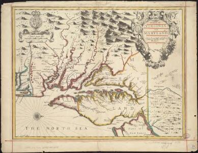
A map of Virginia and Maryland
1 : 1150000 Speed, John Basset, Thomas
Strategic War Points of the United States no.3: the country round the Chesapeake and the Potomac to Washington
Strategic War points of the United States no.3: the country round the Chesapeake and the Potomac to Washington J. Wyld
A Chart of the Chesapeake And Delaware Bays
1 : 354816 Lucas, Fielding Jr.
A Chart of the Chesapeake And Delaware Bays.
1 : 354816 Lucas, Fielding Jr.
Map Of The Seat Of War.
1 : 633600 Monk, Jacob
NOVA VIRGINIÆ TABVLA
DGrijp Sculpt [Amsterdam : Joan Blaeu]
Map of part of Virginia, Maryland and Delaware from the best authorities
1 : 400000 Heyne, Charles E. & G.W. Blunt (Firm)
Virginia / discovered and described by Captayn John Smith, 1606.
from Charts and maps
Composite: New Map Of The Peninsula Embracing Delaware And The Eastern Shores Of Maryland And Virginia
1 : 346480 MacCormac, Walter S.
Strategic war points of the United States

Strategic War Points of the United States no.1: the country round Washington, the Chesapeake and the Potomac
Strategic War Points of the United States no.1: the country round Washington, the Chesapeake and the Potomac. J. Wyld
A map of Virginia : formed from actual surveys and the latest as well as the most accurate observations / by James Madison ; drawn by Wm. Davis ; with extensive additions and corrections to the year 1818.
from Charts and maps
Map to illustrate the 1862 (Virginia) Campaign
Map to illustrate the 1862 (Virginia) Campaign. Map to illustrate the American Civil War of sixty years previously. This small map details the areas of Virginia around the capitals of Washington, D.C. and Richmond where a great amount of fighting took place in 1862 and indeed across the war period. Several places on the map, such as Fredericksburg, Petersburg and Manassas Junction/Bull Run witnessed heavy clashes during the conflict. The map also details railway routes in the region. War Office
Maryland.
1 : 1774080 Scott, Joseph
Maryland and Delaware.; The cerographic atlas of the United States. By Sidney E. Morse, A.M., and Samuel Breese, A.M.
from Supplement to the New York observer. Morse, Sidney E. (Sidney Edwards); Breese, Samuel,
Virginia & Maryland.
1 : 1150000 Bowen, Emanuel
A map of Virginia : formed from actual surveys, and the latest as well as most accurate observations / by James Madison, D.D., president of Wm. & Mary College. ; drawn by Wm. Davis ; engraved by Fred. Bossler, Richmd.
From Charts and maps
Maryland und Delaware / entworfen von D.F. Sotzmann ; W. Sander, sculp.
from Charts and maps
States of Maryland and Delaware.
1 : 800000 Winterbotham, W.
Delaware and Mary-Land / By David H. Burr, New-York; engd. & printed by Illman & Pilbrow.
from Parts David H. Burr; Illman & Pilbrow,
Maryland und Delaware
1 : 500000 Sotzmann, D. F Bey Carl Ernst Bohn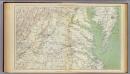
Gen. map II.
1 : 633600 United States. War Department
Bird's-eye view of the Seat of War
Bird's-eye view of the Seat of War, arranged after the latest Surveys. This Bird’s Eye View of the Seat of War, published by Prang, displays the region around the Chesapeake Bay and Potomac River, showing Washington, D.C., Baltimore, Harper’s Ferry, Richmond, Manassas Junction (Bull Run), Fort Monroe and Norfolk Harbour. The map also details railroad lines. It is possible to see a drawing of the Capitol building where Washington, D.C. is labelled. L. Prang & Co.
Der amerikanische Kriegsschauplatz zwischen Washington und Richmond
1 : 1000000 Richmond (Virginie) Petermann, August Debes, Ernst Justus Perthes
Maryland and Delaware.
1 : 1190000 Tanner, Henry S.
Maryland, Delaware.
1 : 1300000 Cram, George Franklin; Davis, Ellis Arthur
Maryland.
1 : 1380000 Tanner, Henry S.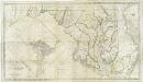
Map of the state of Maryland : laid down from an actual survey of all the principal waters, public roads, and divisions of the counties therein : describing the situation of the cities, towns, villages, houses of worship and other public buildings, furna
from Maryland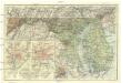
Maryland, Delaware and District of Columbia
1 : 900000 Baltimore (Maryland : oblast) National Geographic Society