Maps of Delaware

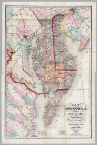
Composite: New Map Of The Peninsula Embracing Delaware And The Eastern Shores Of Maryland And Virginia
1 : 346480 MacCormac, Walter S.
A Chart of the Chesapeake And Delaware Bays
1 : 354816 Lucas, Fielding Jr.
A Chart of the Chesapeake And Delaware Bays.
1 : 354816 Lucas, Fielding Jr.
Virginia & Maryland.
1 : 1150000 Bowen, Emanuel
A map of Virginia and Maryland
1 : 1150000 Speed, John Basset, Thomas
Strategic War Points of the United States no.3: the country round the Chesapeake and the Potomac to Washington
Strategic War points of the United States no.3: the country round the Chesapeake and the Potomac to Washington J. Wyld
Delaware and Mary-Land / By David H. Burr, New-York; engd. & printed by Illman & Pilbrow.
from Parts David H. Burr; Illman & Pilbrow,
Virginia and Maryland.
1 : 1340000 Moll, Herman, d. 1732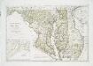
Maryland und Delaware / entworfen von D.F. Sotzmann ; W. Sander, sculp.
from Charts and maps
Map of part of Virginia, Maryland and Delaware from the best authorities
1 : 400000 Heyne, Charles E. & G.W. Blunt (Firm)
Delaware.
from Delaware
Maryland and Delaware.; The cerographic atlas of the United States. By Sidney E. Morse, A.M., and Samuel Breese, A.M.
from Supplement to the New York observer. Morse, Sidney E. (Sidney Edwards); Breese, Samuel,
Maryland.
1 : 1774080 Scott, Joseph
States of Maryland and Delaware.
1 : 800000 Winterbotham, W.
The states of Maryland and Delaware, from the latest surveys
1 : 800000 Wayland, Reid & Smith
Delaware / drawn by F. Lucas, Jr. ; engraved by G.W. Boynton.
from Delaware
A map and chart of those parts of the Bay of Chesapeak, York and James rivers which are at present the seat of war / Jno. Lodge, sc.
from Revolutionary War, 1775-1783
Delaware.
1 : 630000 Lucas, Fielding Jr.
Delaware.
1 : 595000 Finley, Anthony
The legacy of New Sweden: Swedish and Finnish sites in America, 1638-1787 / compiled by Richard Hulan.
Richard Hulan,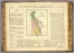
Delaware.
1 : 585000 Buchon, J. A. C.; Carey, H. C.; Lea, I.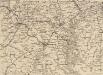
Strategic War Points of the United States no.1: Country Road Washington
Strategic War points of the United States: Country Road Washingon J. Wyld
Delaware.
1 : 619000 Lucas, Fielding Jr.
Delaware.
1 : 447000 DeSilver, Robert
Delaware.
1 : 328000 Carey, Mathew
Delaware.
1 : 440000 Carey, Mathew
Delaware.
1 : 443529 Carey, Mathew
Delaware.
1 : 950400 Carey, Mathew
Delaware.
1 : 443529 Carey, Mathew
Delaware.
1 : 443529 Carey, Mathew