Maps of Maryland

States of Maryland and Delaware.
1 : 800000 Winterbotham, W.
Maryland und Delaware / entworfen von D.F. Sotzmann ; W. Sander, sculp.
from Charts and maps
Maryland and Delaware.
Rand McNally and Company
Map of the state of Maryland : laid down from an actual survey of all the principal waters, public roads, and divisions of the counties therein : describing the situation of the cities, towns, villages, houses of worship and other public buildings, furna
from Maryland
Maryland, Delaware.
1 : 1300000 Cram, George Franklin; Davis, Ellis Arthur
Delaware And Maryland. (with) District of Columbia.
1 : 970000 Colton, G.W.
Maryland und Delaware
1 : 500000 Sotzmann, D. F Bey Carl Ernst Bohn
Maryland.
1 : 1380000 Tanner, Henry S.
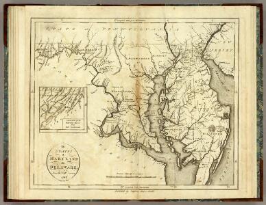
The states of Maryland and Delaware, from the latest surveys
1 : 800000 Wayland, Reid & Smith
Maryland and Delaware.
1 : 1190000 Tanner, Henry S.
Maryland and Delaware.; The cerographic atlas of the United States. By Sidney E. Morse, A.M., and Samuel Breese, A.M.
from Supplement to the New York observer. Morse, Sidney E. (Sidney Edwards); Breese, Samuel,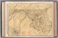
Maryland and Delaware.
1 : 602000 Rand McNally and Company
Delaware and Maryland.
1 : 2000000 Colton, G.W.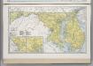
Maryland. Delaware.
1 : 874643 Hammond, C.S.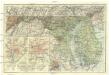
Maryland, Delaware and District of Columbia
1 : 900000 Baltimore (Maryland : oblast) National Geographic Society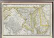
Maryland.
1 : 720000 Rand McNally and Company
Delaware, Maryland.
1 : 975000 Johnson, A.J.
Delaware and Maryland.
1 : 1000000 Colton, G.W.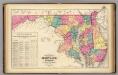
New railroad map of the states of Maryland, Delaware, & District of Columbia.
1 : 633600 Gray, Frank Arnold
Delaware and Maryland. Baltimore.
1 : 958000 Gray, Ormando Willis
Maryland.
1 : 1385000 Finley, Anthony
Maryland, Washington D.C., and Delaware.
1 : 697000 Rand McNally and Company
Maryland.
from Charts and maps M. (Mathew) Carey: [Philadelphia],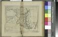
Maryland / W. Barker sculp.; Carey's American pocket atlas; containing nineteen maps... with a brief description of each state.
from Carey's American pocket atlas; containing nineteen maps... with a brief description of each state. Carey, Mathew; Sweitzer, Henry,
The states of Maryland and Delaware, from the latest surveys, 1795 / D. Martin, sculpt. N. York.
from Charts and maps D. Martin,
A New map of the province of Maryland in North America.
from Cartographic materials from the Emmet Collection of Manuscripts Etc. Relating to American History. Hinton, John,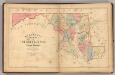
Martenet's Map of Maryland, Atlas Edition.
1 : 950400 Martenet, Simon J.
Maryland.
1 : 1100000 Lucas, Fielding Jr.
Delaware Maryland and Washington D.C
1 : 2000