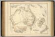
Maps of Australia

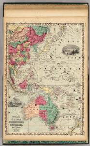
China East Indies Australia And Oceanica.
1 : 22809600 Johnson, A.J.
Carte à repérage Édé. n27, Asie - Océanie - Pacifique
1 : 17000000 Lille : Imprimerie industrielle
Nova & accuratissima totius terrarum orbis tabula nautica, 1
1 Blatt : 51 x 43 cm R. & I. Ottens
Australia and East Indies.
1 : 15000000 Johnson, A.J.
2. Atlas des ganzen Erdkreises.
1 : 61000000 Reichard, C. G.
Oestlicher Planiglob der Erde [Tl.]
1 : 17000000 [...] vervollständigt und berichtiget von C.F. Weiland Weimar : Im Verlage des Geograph. Instituts
Nieuwe kaart van Azië
1 : 12000000 Annotatie: Met afstandentabel (hemelsbreed) [S.l. : Zijlstra]
Far East, Mediterranean Area.
1 : 13000000 Sun Oil Company
Indiae Orientalis, Insularumque Adiacientium Typus. [Karte], in: Theatrum orbis terrarum, S. 399.
1 Karte aus Atlas Ortelius, Abraham Vrients, Jan Baptista
Tasman's kaart van zijn Australische ontdekkingen, 1644 / gereproduceerd op de ware grootte in goud en kleuren naar het orgineel, met tekst, door F.C. Wieder
Annotatie: Facsimile van de manuscriptkaart uit 1644, bewaard in de Mitchell Library, Sydney Frederik Casparus Wieder 1874-1943 's-Gravenhage : Nijhoff
World War II Maps.
Hammond, C.S.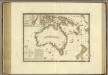
Australie.
1 : 17000000 Brue, Adrien Hubert, 1786-1832
Uebersichts-Karte der ethnographischen Verhältnisse von Asien und von den angrenzenden Theilen Europa'sbearbeitet und herausgegeben mit Unterstützung der kaiserlichen Akademie der Wissenschaften in Wien von Vinzenz v. Haardt
Hartenthurn, Vincenz
Australia and East Indies.
1 : 15000000 Johnson, A.J.
Australia and East Indies.
1 : 15000000 Johnson, A.J.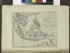
The islands of the East Indies with the channels between India, China & New Holland.
from Carey's general atlas, improved and enlarged : being a collection of maps of the world and quarters, their principal empires, kingdoms, &c.
Australia and New Zealand.
1 : 16600000 Sharpe, J.
[Indischer Ozean, östlicher Teil]
1 Karte : Kupferdruck ; 57 x 45 cm Doncker Hendrik Doncker
Siam, Malacca and the Indian Islands.
from A new systeme of the mathematicks: containing I. Arithmetick, as well natural and decimal, as in species, or the principles of algebra. II. Practical geometry, together with the first six books of Euclid's Elements, as also the eleventh and twelfth, symbo
Carte mar.e d'une partie de l'Asie, ou des Indes Orient.es [et] des isl.es au dessus de l'equat.r
1 Karte : Kupferdruck ; 41 x 49 cm Königliche Akademie der Wissenschaften
[139][142] Orientaliora Indiarum orientalium ... Pascaert ... van Oost Indien, uit: Atlas sive Descriptio terrarum orbis
Annotatie: Gedigitaliseerde versie. Amsterdam. Heiloo : Picturae (vervaardiger), 2015. tiff-bestand. Gedigitaliseerd: 07-01-2015; Origineel: Universiteitsbibliotheek Vrije Universiteit (XL.05127.-) ; Netherlands; Titelpagina ontbreekt Wit, Frederik de Amsterdam : Frederick de Wit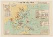
太平洋戰爭日本陸軍戰力喪失一覽圖
1 : 15000000 太平洋戰爭日本陸軍戰力喪失一覽圖 昭和二十二年[1947]4月30日,植野錄夫 编辑,东京:日本地圖株式會社发行。 此图反映了二战反攻阶段东亚、东南亚和太平洋地区盟军与日军的战斗形势,包括东北苏军进攻路线、中国本部反攻路线、东南亚和太平洋诸岛美军进攻路线等。图中用蓝色标注了此时日军在中国、东南亚及本岛的军队部署及战争损失统计。附表罗列自1937年以来日本历次战争的名称、时间、参战部队及军力损失。另有《飛行機生産表》,显示日军战机的生产配备情况。 附插图1幅:《内地戰災被害状況圖》。 1图,彩色,日文,图幅61 x 86 cm,比例尺1:15,000,000,经纬度E80°-W160°;S10°-N55°。 Harvard-Yenching | Manchuguo J-0827;Hollis Number:014623825 植野錄夫 日本地圖株式會社
Oosterdeel van Oost Indien [Karte], in: De Nieuwe Groote Vermeerderde Zee-Atlas ofte Water-Werelt, S. 59.
1 Karte aus Atlas Doncker, Hendrick
Suite de l'Ocean oriental contenant les isles de la Sonde les costes de Tunquin et de la Chine les isles du Japon les Philippines Moluques
1 : 7400000 Filipíny Bellin, Jacques-Nicolas
Java-China-Japan Lyn / specially prep. by Edward Stanford Ltd.
1 : 6969600 Annotatie: Met afstandentabel (in zeemijlen) Stanford's Geographical Establishment, Londen London : Stanford
Festland von Australien und benachbarte Inseln
Hand-Atlas über alle Theile der Erde nach dem neuesten Zustande und über das Weltgebäude Stieler, Adolf bei Justus Perthes
India quae Orientalis dicitur, Et Insulae Adiacentes. [Karte], in: Le théâtre du monde, ou, Nouvel atlas contenant les chartes et descriptions de tous les païs de la terre, Bd. 2, S. 239.
1 Karte aus Atlas Blaeu, Willem Janszoon und Blaeu, Joan Blaeu, Willem Janszoon
Continent von Australien und Neuseeland
1 : 12000000 Austrálie Kiepert, Heinrich Bembe, W. Dietrich Reimer
Australien
Plastischer Schul-Atlas über alle Theile der Erde : in 24 Karten Woldermann, G Verlag von P. Eckerlein