Maps of Australia

Oestlicher Planiglob der Erde [Tl.]
1 : 17000000 [...] vervollständigt und berichtiget von C.F. Weiland Weimar : Im Verlage des Geograph. Instituts
Indian Ocean.
1 : 26000000 Johnston, Alexander Keith, 1804-1871
Carte à repérage Édé. n27, Asie - Océanie - Pacifique
1 : 17000000 Lille : Imprimerie industrielle
Indian Ocean cables, wireless stations.
1 : 40000000 Philip, George
2. Atlas des ganzen Erdkreises.
1 : 61000000 Reichard, C. G.
Indischer Ozean
1 : 30000000 Indický oceán Institut für Meereskunde
Mare di India [Karte], in: Novus atlas absolutissimus, Bd. 9, S. 98.
1 Karte aus Atlas Janssonius Offizin
Nieuwe kaart van Azië
1 : 12000000 Annotatie: Met afstandentabel (hemelsbreed) [S.l. : Zijlstra]
Physical Chart of the Indian Ocean
The physical atlas Johnston, Alexander Keith William Blackwood & Sons
Mar di India [Karte], in: Het vijfde Deel Des Grooten Atlas : Vervatende De Water-Weereld, S. 82.
1 Karte aus Atlas Jansson, Jan Jansson, Jan
[139][142] Orientaliora Indiarum orientalium ... Pascaert ... van Oost Indien, uit: Atlas sive Descriptio terrarum orbis
Annotatie: Gedigitaliseerde versie. Amsterdam. Heiloo : Picturae (vervaardiger), 2015. tiff-bestand. Gedigitaliseerd: 07-01-2015; Origineel: Universiteitsbibliotheek Vrije Universiteit (XL.05127.-) ; Netherlands; Titelpagina ontbreekt Wit, Frederik de Amsterdam : Frederick de Wit
India quae Orientalis dicitur, Et Insulae Adiacentes. [Karte], in: Le théâtre du monde, ou, Nouvel atlas contenant les chartes et descriptions de tous les païs de la terre, Bd. 2, S. 239.
1 Karte aus Atlas Blaeu, Willem Janszoon und Blaeu, Joan Blaeu, Willem Janszoon
Physikalische Karte vom Indischen Meere
Erster Band, enthaltend in vier Abtheilungen die Erscheinungen der anorganischen Natur: 1. Meteorologie und Klimatographie. 2. Hydrologie und Hydrographie. 3. Geologie. 4. Tellurischer Magnetismus Humboldt, Alexander von Verlag von Justus Perthes
India quae Orientalis dicitur, Et Insulae Adiacentes. [Karte], in: Theatrum orbis terrarum, sive, Atlas novus, Bd. 2, S. 248.
1 Karte aus Atlas Blaeu, Joan Blaeu, Willem Janszoon
India quae Orientalis dicitur, et Insulae Adiacentes. [Karte], in: Novus Atlas, das ist, Weltbeschreibung, Bd. 2, S. 263.
1 Karte aus Atlas Blaeu, Joan Blaeu, Willem Janszoon
Oosterdeel van Oost Indien [Karte], in: De Nieuwe Groote Vermeerderde Zee-Atlas ofte Water-Werelt, S. 59.
1 Karte aus Atlas Doncker, Hendrick
India quae Orientalis dicitur, et Insulae Adiacentes. [Karte], in: Novus atlas absolutissimus, Bd. 6, S. 144.
1 Karte aus Atlas Janssonius Offizin
標準大東亜分圖. 共荣圈全圖
1 : 27800000 標準大東亞分圖‧共荣圈全圖 昭和十八年[1943]7月25日再版,芹澤馨吾 製圖,东京:統政社株式會社 發行 此图演示日本大东亚共荣圈的空间范围,包含亚洲、大洋洲、太平洋和印度洋的广大地区。 1图,彩色,日文,图幅54.5 x 77.3 cm,比例尺1:27,800,000,经纬度约为E30°-W160°; S45°-N60°。 Harvard-YenchingManchuguo J-0831;Hollis Number:014623995 芹澤馨吾 統政社株式會社
America (south)
1 : 24000000 Lizars, Daniel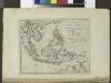
The islands of the East Indies with the channels between India, China & New Holland.
from Carey's general atlas, improved and enlarged : being a collection of maps of the world and quarters, their principal empires, kingdoms, &c.
Indian Ocean
1 : 20000000 Austrálie National Geographic Society
Australia and East Indies.
1 : 15000000 Johnson, A.J.
Far East, Mediterranean Area.
1 : 13000000 Sun Oil Company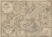
Indiae Orientalis, Insularumque Adiacientium Typus. [Karte], in: Theatrum orbis terrarum, S. 399.
1 Karte aus Atlas Ortelius, Abraham Vrients, Jan Baptista
China East Indies Australia And Oceanica.
1 : 22809600 Johnson, A.J.
Pilot chart of the Indian Ocean
1 : 18000000 Indický oceán (oblast) Maury, Matthew Fontaine Hydrographic Office
Pilot chart of the Indian Ocean
1 : 18000000 Indický oceán (oblast) Maury, Matthew Fontaine Hydrographic Office
[Kaart], uit: Australien
1 : 10000000 Braunschweig [etc.] : Westermann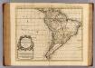
L'Amerique Meridionale.
1 : 18500000 L'Isle, Guillaume de, 1675-1726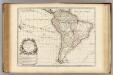
L'Amerique Meridionale.
1 : 18500000 L'Isle, Guillaume de, 1675-1726
![Oestlicher Planiglob der Erde [Tl.]](https://images-2.georeferencer.com/images/iiif/386372195925/full/,300/0/native.jpg)

