Maps of Malay Archipelago
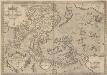
Indiae Orientalis, Insularumque Adiacientium Typus. [Karte], in: Theatrum orbis terrarum, S. 399.
1 Karte aus Atlas Ortelius, Abraham Vrients, Jan Baptista
Carte à repérage Édé. n27, Asie - Océanie - Pacifique
1 : 17000000 Lille : Imprimerie industrielle
India quae Orientalis dicitur, Et Insulae Adiacentes. [Karte], in: Theatrum orbis terrarum, sive, Atlas novus, Bd. 2, S. 248.
1 Karte aus Atlas Blaeu, Joan Blaeu, Willem Janszoon
India quae Orientalis dicitur, et Insulae Adiacentes. [Karte], in: Novus Atlas, das ist, Weltbeschreibung, Bd. 2, S. 263.
1 Karte aus Atlas Blaeu, Joan Blaeu, Willem Janszoon
Siam, Malacca and the Indian Islands.
from A new systeme of the mathematicks: containing I. Arithmetick, as well natural and decimal, as in species, or the principles of algebra. II. Practical geometry, together with the first six books of Euclid's Elements, as also the eleventh and twelfth, symbo
India quae Orientalis dicitur, Et Insulae Adiacentes. [Karte], in: Le théâtre du monde, ou, Nouvel atlas contenant les chartes et descriptions de tous les païs de la terre, Bd. 2, S. 239.
1 Karte aus Atlas Blaeu, Willem Janszoon und Blaeu, Joan Blaeu, Willem Janszoon
Asiae Nova Descriptio [Karte], in: Gerardi Mercatoris Atlas, sive, Cosmographicae meditationes de fabrica mundi et fabricati figura, S. 511.
1 Karte aus Atlas Mercator, Gerhard Montanus, Petrus
India quae Orientalis dicitur, et Insulae Adiacentes. [Karte], in: Novus atlas absolutissimus, Bd. 6, S. 144.
1 Karte aus Atlas Janssonius Offizin
Ostindien mit den Inseln
Schul-Atlas über alle Theile der Erde nach dem neuesten Zustande, und über das Weltgebäude Stieler, Adolf Justus Perthes
Far East, Mediterranean Area.
1 : 13000000 Sun Oil Company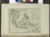
The islands of the East Indies with the channels between India, China & New Holland.
from Carey's general atlas, improved and enlarged : being a collection of maps of the world and quarters, their principal empires, kingdoms, &c.
INDIA | quæ | ORIENTALIS | dicitur | ET | INSVLÆ | ADIACENTES.
[Amsterdam : Joan Blaeu]
Buddhaistischen Staaten-Systems.
1 : 25000000 Flemming, Carl
Indes, la Chine.
1 : 10700000 L'Isle, Guillaume de, 1675-1726
Indes, la Chine.
1 : 10700000 L'Isle, Guillaume de, 1675-1726


Asia [...] [Karte], in: Atlas, sive, Cosmographicae meditationes de fabrica mundi et fabricati figura, S. 71.
1 Karte aus Atlas Mercator, Gerhard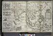
A map of the East-Indies and the adjacent countries ; with the settlements, factories and territories explaning what belongs to England, Spain, France, Holland, Denmark, Portugal &c. ...
from The world described, or, A new and correct sett of maps : shewing the kingdoms and states in all the known parts of the earth, with the principal cities, and most considerable towns in the world ... / ... by Herman Moll, geographer ...
2. Atlas des ganzen Erdkreises.
1 : 61000000 Reichard, C. G.
Nieuwe kaart van Asia volgens de laatste ontdekkingen
1 : 60000000 [S.l.] : [s.n.]
Map of Hindoostan, Farther India, China, and Tibet.
from Mitchell's new general atlas, containing maps of the various countries of the world, plans of cities, etc., embraced in fifty-three quarto maps., forming a series of eighty four maps and plans, together with valuable statistical tables.
Indie a Dálný východ
1 : 10000000 Dálný východ Kuchař, Karel V. Neubert a synové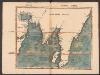
Tabula Moderna Indiae [Karte], in: Claudii Ptolemei viri Alexandrini mathematice discipline philosophi doctissimi geographie opus [...], S. 275.
1 Karte aus Atlas Waldseemüller, Martin [und Ptolemaeus, Claudius] Übelin, Georg
Kaart van de afdeeling, eiland Saleijer (Silaijara), uit: Kaart van Zuid Celebes met uitzondering van het Rijk Gowa
1 : 200000 Annotatie: Met administratieve indeling 's-Gravenhage : Topographische Inrichting
Asiae Nova Descriptio. [Karte], in: Theatrum orbis terrarum, S. 55.
1 Karte aus Atlas Ortelius, Abraham Vrients, Jan Baptista
Oestlicher Planiglob der Erde [Tl.]
1 : 17000000 [...] vervollständigt und berichtiget von C.F. Weiland Weimar : Im Verlage des Geograph. Instituts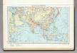
104. Asia (Outside the USSR) Communications. The World Atlas.
1 : 30000000 USSR (Union of Soviet Socialist Republics).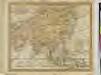
ASIA FROM THE BEST AUTHORITIES.

![Indiae Orientalis, Insularumque Adiacientium Typus. [Karte], in: Theatrum orbis terrarum, S. 399.](https://images-2.georeferencer.com/images/iiif/552016782223/full/,300/0/native.jpg)

