Maps of China

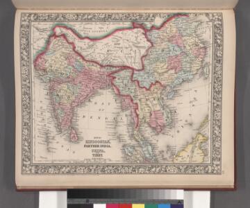
Map of Hindoostan, Farther India, China, and Tibet.
from Mitchell's new general atlas, containing maps of the various countries of the world, plans of cities, etc., embraced in fifty-three quarto maps., forming a series of eighty four maps and plans, together with valuable statistical tables.
A map of the East-Indies and the adjacent countries ; with the settlements, factories and territories explaning what belongs to England, Spain, France, Holland, Denmark, Portugal &c. ...
from The world described, or, A new and correct sett of maps : shewing the kingdoms and states in all the known parts of the earth, with the principal cities, and most considerable towns in the world ... / ... by Herman Moll, geographer ...
Ostindien mit den Inseln
Schul-Atlas über alle Theile der Erde nach dem neuesten Zustande, und über das Weltgebäude Stieler, Adolf Justus Perthes
Indiae Orientalis, Insularumque Adiacientium Typus. [Karte], in: Theatrum orbis terrarum, S. 399.
1 Karte aus Atlas Ortelius, Abraham Vrients, Jan Baptista
104. Asia (Outside the USSR) Communications. The World Atlas.
1 : 30000000 USSR (Union of Soviet Socialist Republics).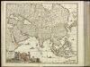
[4][4] Accuratissima totius Asiae tabula, uit: Atlas sive Descriptio terrarum orbis
Annotatie: Gedigitaliseerde versie. Amsterdam. Heiloo : Picturae (vervaardiger), 2015. tiff-bestand. Gedigitaliseerd: 07-01-2015; Origineel: Universiteitsbibliotheek Vrije Universiteit (XL.05127.-) ; Netherlands; Titelpagina ontbreekt Wit, Frederik de Amsterdam : Frederick de Wit
Indien und Ostasien
1 : 10000000 Asie východní Verlagsanstalt List & von Bressensdorf
Tabula Moderna Indiae [Karte], in: Claudii Ptolemei viri Alexandrini mathematice discipline philosophi doctissimi geographie opus [...], S. 275.
1 Karte aus Atlas Waldseemüller, Martin [und Ptolemaeus, Claudius] Übelin, Georg
Ostindien und China
E. von Sydow's Schul-Atlas in sechs und dreissig Karten Sydow, Emil von bei Justus Perthes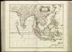
[75][75] Tabula Indiae Orientalis, uit: Atlas sive Descriptio terrarum orbis
Annotatie: Gedigitaliseerde versie. Amsterdam. Heiloo : Picturae (vervaardiger), 2015. tiff-bestand. Gedigitaliseerd: 07-01-2015; Origineel: Universiteitsbibliotheek Vrije Universiteit (XL.05127.-) ; Netherlands; Titelpagina ontbreekt Wit, Frederik de Amsterdam : Frederick de Wit
Indiae orientalis, nec non insularum adiacentium nova descriptio
1 : 15000000 Asie jihovýchodní Visscher, Nicolaes Jansz.
Indiae orientalis, nec non insularum adiacentium nova descriptio
1 : 15000000 Asie jihovýchodní Visscher, Nicolaus per Nicolaum Visscher
Indie a Dálný východ
1 : 10000000 Dálný východ Kuchař, Karel V. Neubert a synové
Ost-Indien.
1 : 18500000 Stulpnagel, F.v.
Buddhaistischen Staaten-Systems.
1 : 25000000 Flemming, Carl
Atlas für Industrie- und Handelsgeographie: Für commercielle und technische Lehranstalten, für Kaufleute und Industrielle

Indes, la Chine.
1 : 10700000 L'Isle, Guillaume de, 1675-1726
Indes, la Chine.
1 : 10700000 L'Isle, Guillaume de, 1675-1726
Ost-Indien
Hand-Atlas über alle Theile der Erde und über das Weltgebäude Stieler, Adolf Justus Perthes
Charte von China und den angränzenden Ländern, und Völkerschaften so wie dem letzten Kaiser Tschien-Long unterworfen waren
1 : 47500000 Asie jihovýchodní Macartney, George Macartney
Charte von China und den angränzenden Ländern, und Völkerschaften so wie dem letzten Kaiser Tschien-Long unterworfen waren
1 : 47500000 Asie jihovýchodní Macartney, George Macartney
CHARTE von CHINA und den angränzenden Ländern, und Völkerschaften so wie sie dem letzten Kaiser Tschien-Long unterworfen waren
1 : 47500000 Asie jihovýchodní Macartney, George Macartney
Asia wie es jetziger zeit nach den fuernemesten Herrschafften abgetheilet und beschriben ist
1 : 22000000 1 Karte : Holzschnitt ; 30 x 36 cm Münster, Sebastian [Sebastian Henricpetri]
Ost-Indien mit den Inseln
Hand-Atlas über alle Theile der Erde nach dem neuesten Zustande und über das Weltgebäude Stieler, Adolf bei Justus Perthes
Ostindien
Allgemeiner Atlas [Walch, Johannes] im Verlag bei Johannes Walch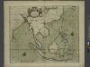
A chart of the eastermost part of the EAST INDIES and CHINA, from cape comarine to IAPAN, with all adjacent Islands
from The sea-atlas : containing an hydrographical description of most of the sea-coasts of the known parts of the world.
Ost-Indien
Handatlas über alle Theile der Erde und über das Weltgebäude Stieler, Adolf Justus Perthes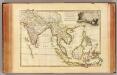
Indes Orientales.
1 : 16250000 Bonne, Rigobert, 1727-1794
Ostindien und China
1 : 25000000 Himálaj Kocen, Blaž Eduard Hölzel