Maps of China

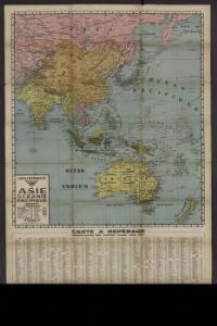
Carte à repérage Édé. n27, Asie - Océanie - Pacifique
1 : 17000000 Lille : Imprimerie industrielle
Nova & accuratissima totius terrarum orbis tabula nautica, 3
1 Blatt : 51 x 48 cm R. & I. Ottens
Neue Karte des westlichstens Theiles der Welt
1 Karte : Kupferdruck ; 32 x 34 cm Weidmann/Philipp E. Reich
India Extrema; XIX. Nova Tabula. [Karte], in: Geographia universalis vetus et nova complectens Claudii Ptolemaei Alexandrini enarrationis libros VIII, S. 353.
1 Karte aus Atlas Münster, Sebastian [und Ptolemaeus, Claudius]
Map of America by A. Arrowsmith.
1 : 14700000 Arrowsmith, Aaron
Carte pour servir a l'histoire philosophique et politique des etablissemens et du commerce des Europeens dans les deux Indes
1 Karte : Kupferdruck ; 30 x 45 cm Bonne s.n.
America.
1 : 47000000 Teesdale, Henry
Nieuwe kaart van Azië
1 : 12000000 Annotatie: Met afstandentabel (hemelsbreed) [S.l. : Zijlstra]
Amerika
1 : 30500000 Amerika Mollo, Tranquillo Tranquillo Mollo
China East Indies Australia And Oceanica.
1 : 22809600 Johnson, A.J.
標準大東亜分圖. 共荣圈全圖
1 : 27800000 標準大東亞分圖‧共荣圈全圖 昭和十八年[1943]7月25日再版,芹澤馨吾 製圖,东京:統政社株式會社 發行 此图演示日本大东亚共荣圈的空间范围,包含亚洲、大洋洲、太平洋和印度洋的广大地区。 1图,彩色,日文,图幅54.5 x 77.3 cm,比例尺1:27,800,000,经纬度约为E30°-W160°; S45°-N60°。 Harvard-YenchingManchuguo J-0831;Hollis Number:014623995 芹澤馨吾 統政社株式會社
Asia
Hand-Atlas über alle Theile der Erde nach dem neuesten Zustande und über das Weltgebäude Stieler, Adolf bei Justus Perthes
2. Atlas des ganzen Erdkreises.
1 : 61000000 Reichard, C. G.
Asie spheroidale.
1 : 41000000 Garnier, F. A., 1803-1863
Oestlicher Planiglob der Erde [Tl.]
1 : 17000000 [...] vervollständigt und berichtiget von C.F. Weiland Weimar : Im Verlage des Geograph. Instituts
Nouvelle carte des parties occidentales du monde
1 Karte : Kupferdruck ; 32 x 33 cm Lattré; Choffard Nyon
[Neuer Atlas der ganzen Erde nach den neuesten Bestimmungen ... : III.] Asien
Entworfen und gezeichnet von F.W. Streit H. Leutemann sc. Leipzig : J.C. Hinrichs'sche Buchhandlung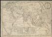
Map of the European settlements in the East Indies and on the eastern coast of Africa including part of Europe
1 : 33000000
Asia
Handatlas über alle Theile der Erde und über das Weltgebäude Stieler, Adolf Justus Perthes
Carte d'Asie : dressé sur les memoires envoyéz par le czar a l'Academie Royale des Science : sur ce que les Arabes nous ont laissé de plus exact des pays orientaux : sur un grand nombre de routiers de terre et de mer et des cartes manuscrites detaillées : le tout assujetti aux observations de l'Academie et a celles de R.R.P.P. Jesuites et autres mathematiciens
1 : 20000000 par G. De l'Isle nouvellement corrigée apres les dernieres decouvertes faite par l'Academie de Petersbourg A Amsterdam : par Covens et Mortier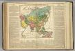
Asia.
1 : 41000000 Lavoisne, M.
Asien
Atlas der Pflanzengeographie über alle Theile der Erde Rudolphi, Ludwig Verlag der Nicolaischen Buchhandlung
Asien
Asie Müller, Carl Liechtenstern, Joseph Marx von im Verlage des Kunst und Industrie Comptoirs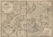
Indiae Orientalis, Insularumque Adiacientium Typus. [Karte], in: Theatrum orbis terrarum, S. 399.
1 Karte aus Atlas Ortelius, Abraham Vrients, Jan Baptista
Asiae nova delineatio
Asie Visscher, Nicolaes Jansz. Spiegel, Hendrik N. Visscher
Asiae nova delineatio
Asie Visscher, Nicolaus Spiegel, Hendrik N. Visscher
Asiae Nova Delineatio [Karte], in: Novus atlas absolutissimus, Bd. 6, S. 88.
1 Karte aus Atlas Janssonius Offizin
Physical Chart of the Indian Ocean
The physical atlas Johnston, Alexander Keith William Blackwood & Sons
Asien nach den neuesten Untersuchungen und Reiseberichten
Historisch-genealogisch-geographischer Atlas von Le Sage Las Cases, Emmanuel Auguste Dieudonné Marius Joseph de Johann Velten, Kunsthändler