Maps of Malay Archipelago

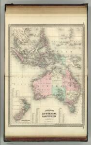
Australia and East Indies.
1 : 15000000 Johnson, A.J.
Australia and East Indies.
1 : 15000000 Johnson, A.J.
Australia and East Indies.
1 : 15000000 Johnson, A.J.
Tasman's kaart van zijn Australische ontdekkingen, 1644 / gereproduceerd op de ware grootte in goud en kleuren naar het orgineel, met tekst, door F.C. Wieder
Annotatie: Facsimile van de manuscriptkaart uit 1644, bewaard in de Mitchell Library, Sydney Frederik Casparus Wieder 1874-1943 's-Gravenhage : Nijhoff
[139][142] Orientaliora Indiarum orientalium ... Pascaert ... van Oost Indien, uit: Atlas sive Descriptio terrarum orbis
Annotatie: Gedigitaliseerde versie. Amsterdam. Heiloo : Picturae (vervaardiger), 2015. tiff-bestand. Gedigitaliseerd: 07-01-2015; Origineel: Universiteitsbibliotheek Vrije Universiteit (XL.05127.-) ; Netherlands; Titelpagina ontbreekt Wit, Frederik de Amsterdam : Frederick de Wit
Oosterdeel van Oost Indien [Karte], in: De Nieuwe Groote Vermeerderde Zee-Atlas ofte Water-Werelt, S. 59.
1 Karte aus Atlas Doncker, Hendrick
[Kaart], uit: Overzichtskaart van den Nederlandsch-Indischen Archipel / uitgave van de Afdeeling Handel van het Departement van Landbouw, Nijverheid en Handel
1 : 10000000 titelvariant: Nederlandsch-Indië; Annotatie: Omslagtitel: Nederlandsch-Indië; Annotatie geografische gegevens: Legenda Departement van Landbouw, Nijverheid en Handel, Buitenzorg. Afdeeling Handel Buitenzorg : Departement van Landbouw, Nijverheid en Handel / (Weltevreden (Batavia) : Reproductiebedrijf Topografische Dienst)
[Indischer Ozean, östlicher Teil]
1 Karte : Kupferdruck ; 57 x 45 cm Doncker Hendrik Doncker
Kaart van Nieuw Holland, Nieuw Guinea, en omliggende eilanden : behoorende tot de door het Provinciaal Utrechtsch Genootschap bekroonde Verhandeling van R.G. Bennet en J. van Wyk Rz.
1 : 1150000 R. van Wyk Jz. del. Te Dordrecht : by J. de Vos & Co.
Kaart van Nieuw Holland, Nieuw Guinea en omliggende eilanden / [getekend door] R. van Wijk
Dordrecht : J. de Vos
Australie.
1 : 17000000 Brue, Adrien Hubert, 1786-1832
Malay Archipelago, Or East India Islands.
1 : 21500000 Tallis, J. & F.
Insularum Indiae Orientalis : nova descriptio
1 : 12000000 Jansson, Jan, 1588-1664 Ioannis Ianssonius
Uebersichts-Karte der ethnographischen Verhältnisse von Asien und von den angrenzenden Theilen Europa'sbearbeitet und herausgegeben mit Unterstützung der kaiserlichen Akademie der Wissenschaften in Wien von Vinzenz v. Haardt
Hartenthurn, Vincenz
Australia and New Zealand.
1 : 16600000 Sharpe, J.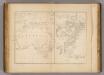
Australia & New South Wales.
1 : 26000000 United States Exploring Expedition (1838-1842); Wilkes, Charles, 1798-1877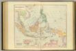
Asiatic Archipelago.
1 : 94000000 Stanford, Edward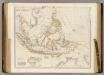
Asiatic Archipelago.
1 : 9500000 Arrowsmith, John
Australia.
1 : 40000000 Fenner, Rest.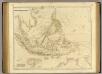
Asiatic Archipelago.
1 : 9500000 Arrowsmith, John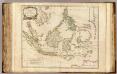
Indes Orientales.
1 : 8400000 Robert de Vaugondy, Gilles, 1688-1766
[Die Niederlaendischen u. Spanischen Südsee Inseln]
[Allgemeiner Atlas über alle Theile der Erde in 29 Blättern] Ziegler, Jakob Melchior Top. Anstalt v. J. Wurster u. Comp.
Insulae Indiae Orientalis Praecipuae, In quibus Moluccae celeberrimae sunt. [Karte], in: Gerardi Mercatoris Atlas, sive, Cosmographicae meditationes de fabrica mundi et fabricati figura, S. 538.
1 Karte aus Atlas Mercator, Gerhard Montanus, Petrus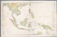
Nederlandsch-Indië en omgeving / Topografische Dienst
1 : 5000000 Topographische Dienst in Nederlandsch-Indië Batavia : Topografische Dienst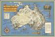
Australia: her natural and industrial resources
1 : 8944941 Gill, Leslie MacDonald, 1884-1947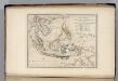
Islands of the East Indies.
1 : 23000000 Carey, Mathew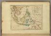
Islands of the East Indies.
1 : 23000000 Carey, Mathew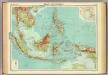
Malay Archipelago.
1 : 10000000 John Bartholomew and Son
Hinterindien, Malayische Archipel.
1 : 18000000 Andree, Richard