Maps of Australia

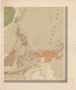
Uebersichts-Karte der ethnographischen Verhältnisse von Asien und von den angrenzenden Theilen Europa'sbearbeitet und herausgegeben mit Unterstützung der kaiserlichen Akademie der Wissenschaften in Wien von Vinzenz v. Haardt
Hartenthurn, Vincenz
The islands of the East Indies with the channels between India, China & New Holland.
from Carey's general atlas, improved and enlarged : being a collection of maps of the world and quarters, their principal empires, kingdoms, &c.
Suite de l'Ocean oriental contenant les isles de la Sonde les costes de Tunquin et de la Chine les isles du Japon les Philippines Moluques
1 : 7400000 Filipíny Bellin, Jacques-Nicolas
[Indischer Ozean, östlicher Teil]
1 Karte : Kupferdruck ; 57 x 45 cm Doncker Hendrik Doncker
Siam, Malacca and the Indian Islands.
from A new systeme of the mathematicks: containing I. Arithmetick, as well natural and decimal, as in species, or the principles of algebra. II. Practical geometry, together with the first six books of Euclid's Elements, as also the eleventh and twelfth, symbo
World War II Maps.
Hammond, C.S.
Insularum Indiae Orientalis : nova descriptio
1 : 12000000 Jansson, Jan, 1588-1664 Ioannis Ianssonius
Australia and East Indies.
1 : 15000000 Johnson, A.J.
Australia and East Indies.
1 : 15000000 Johnson, A.J.
Tasman's kaart van zijn Australische ontdekkingen, 1644 / gereproduceerd op de ware grootte in goud en kleuren naar het orgineel, met tekst, door F.C. Wieder
Annotatie: Facsimile van de manuscriptkaart uit 1644, bewaard in de Mitchell Library, Sydney Frederik Casparus Wieder 1874-1943 's-Gravenhage : Nijhoff
Japanese aerodromes in Southwest Pacific Area, 20th November, 1944 / comp. by Allied Air Force SWPA
Allied Air Force SWPA [S.l.] : Allied Air Force SWPA
Kaart van Nieuw Holland, Nieuw Guinea, en omliggende eilanden : behoorende tot de door het Provinciaal Utrechtsch Genootschap bekroonde Verhandeling van R.G. Bennet en J. van Wyk Rz.
1 : 1150000 R. van Wyk Jz. del. Te Dordrecht : by J. de Vos & Co.
Malay Archipelago, Or East India Islands.
1 : 21500000 Tallis, J. & F.
Kaart van Nieuw Holland, Nieuw Guinea en omliggende eilanden / [getekend door] R. van Wijk
Dordrecht : J. de Vos
[Die Niederlaendischen u. Spanischen Südsee Inseln]
[Allgemeiner Atlas über alle Theile der Erde in 29 Blättern] Ziegler, Jakob Melchior Top. Anstalt v. J. Wurster u. Comp.
[Kaart], uit: Overzichtskaart van den Nederlandsch-Indischen Archipel / uitgave van de Afdeeling Handel van het Departement van Landbouw, Nijverheid en Handel
1 : 10000000 titelvariant: Nederlandsch-Indië; Annotatie: Omslagtitel: Nederlandsch-Indië; Annotatie geografische gegevens: Legenda Departement van Landbouw, Nijverheid en Handel, Buitenzorg. Afdeeling Handel Buitenzorg : Departement van Landbouw, Nijverheid en Handel / (Weltevreden (Batavia) : Reproductiebedrijf Topografische Dienst)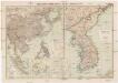
Russisch-Japanischer Kriegsschauplatz
1 : 12000000 Japonsko Kiepert, Richard Sprigade, Paul Dietrich Reimer
Nederlandsch-Indië en omgeving / Topografische Dienst
1 : 5000000 Topographische Dienst in Nederlandsch-Indië Batavia : Topografische Dienst
Ost-Asien
1 : 12000000 Asie východní Kiepert, Richard Sprigade, Paul Geographische Verlagshandlung Dietrich Reimer (Ernst Vohsen)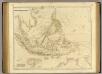
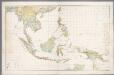
Asiatic Archipelago.
1 : 9500000 Arrowsmith, John
Ost-Asien / Neubearb. von Richard Kiepert und Paul Sprigade
1 : 12000000 Richard Kiepert 1846-1915; Paul Sprigade Berlin : Dietrich Reimer (Ernst Vohsen)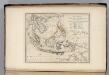
Islands of the East Indies.
1 : 23000000 Carey, Mathew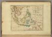
Islands of the East Indies.
1 : 23000000 Carey, Mathew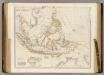
Asiatic Archipelago.
1 : 9500000 Arrowsmith, John
Indiae Orientalis Nova Descriptio [Karte], in: Novus atlas absolutissimus, Bd. 6, S. 150.
1 Karte aus Atlas Janssonius Offizin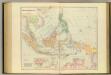
Asiatic Archipelago.
1 : 94000000 Stanford, Edward
Indiae Orientalis Nova Descriptio [Karte], in: Gerardi Mercatoris et I. Hondii Newer Atlas, oder, Grosses Weltbuch, Bd. 2, S. 362.
1 Karte aus Atlas Mercator, Gerhard und Hondius, Jodocus Jansson, Jan
Hinterindien, Malayische Archipel.
1 : 18000000 Andree, Richard