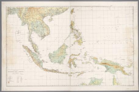
Maps of Malay Archipelago
Nederlandsch-Indië en omgeving / Topografische Dienst
1 : 5000000 Topographische Dienst in Nederlandsch-Indië Batavia : Topografische Dienst
Indiae Orientalis Nova Descriptio [Karte], in: Novus atlas absolutissimus, Bd. 6, S. 150.
1 Karte aus Atlas Janssonius Offizin
Insularum Indiae Orientalis : nova descriptio
1 : 12000000 Jansson, Jan, 1588-1664 Ioannis Ianssonius
Indiae Orientalis Nova Descriptio [Karte], in: Gerardi Mercatoris et I. Hondii Newer Atlas, oder, Grosses Weltbuch, Bd. 2, S. 362.
1 Karte aus Atlas Mercator, Gerhard und Hondius, Jodocus Jansson, Jan
Malay Archipelago, Or East India Islands.
1 : 21500000 Tallis, J. & F.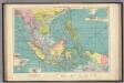
East Indian ports.
1 : 10000000 Philip, George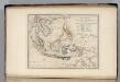
Islands of the East Indies.
1 : 23000000 Carey, Mathew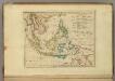
Islands of the East Indies.
1 : 23000000 Carey, Mathew
Ostindien & China
Atlas der Hydrographie Berghaus, Hermann Justus Perthes
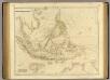
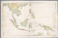
Asiatic Archipelago.
1 : 9500000 Arrowsmith, John
Hinterindien, Malayische Archipel.
1 : 18000000 Andree, Richard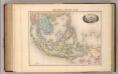
Indo-Chine et Archipel D'Asie.
1 : 14400000 Migeon, J.
Japanese aerodromes in Southwest Pacific Area, 20th November, 1944 / comp. by Allied Air Force SWPA
Allied Air Force SWPA [S.l.] : Allied Air Force SWPA
Insulae Indiae Orientalis Praecipuae, In quibus Moluccae celeberrimae sunt. [Karte], in: Gerardi Mercatoris Atlas, sive, Cosmographicae meditationes de fabrica mundi et fabricati figura, S. 538.
1 Karte aus Atlas Mercator, Gerhard Montanus, Petrus
Islands: China-New Holland.
1 : 23000000 Bowen, Frances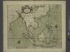
A chart of the eastermost part of the EAST INDIES and CHINA, from cape comarine to IAPAN, with all adjacent Islands
from The sea-atlas : containing an hydrographical description of most of the sea-coasts of the known parts of the world.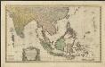
Carte des Indes Orientales
1 : 10000000 dessinée suivant les observations les plus recentes, dont le principal est tirée des cartes hydrographiques de Mr. D'Apres de Mannevillette dediée tres humblement à [...] Guillaume Charles Henry Friso [...] par [...] l'auteur et les Heritiers de Homan(n) ; S. Dorn fe. [Nürnberg] : Heritiers de Homann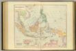
Asiatic Archipelago.
1 : 94000000 Stanford, Edward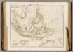
Asiatic Archipelago.
1 : 9500000 Arrowsmith, John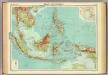
Malay Archipelago.
1 : 10000000 John Bartholomew and Son
East Indies from the best authorites
1 : 26000000
Asie 2.
1 : 7150000 Anville, Jean Baptiste Bourguignon d, 1697-1782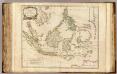
Indes Orientales.
1 : 8400000 Robert de Vaugondy, Gilles, 1688-1766
Die Ostindischen Inseln
Hand-Atlas über alle Theile der Erde nach dem neuesten Zustande und über das Weltgebäude Stieler, Adolf bei Justus Perthes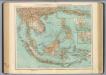
95-96. Indocina, Siam, Arcipelago Malese.
1 : 10000000 Touring club italiano
Die Ostindischen Inseln
Handatlas über alle Theile der Erde und über das Weltgebäude Stieler, Adolf Justus Perthes
Kaert van de Molocques : zeer correckt afgheteyckent met allen zijn eylanden ende sterckten, met een afbeeldinghe van de Straat van Botton / [Jan Cornelisz. Moy?]
[S.l. : s.n.]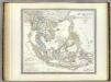
Hinter Indien.
1 : 10000000 Weiland, C. F. (Carl Ferdinand), d. 1847