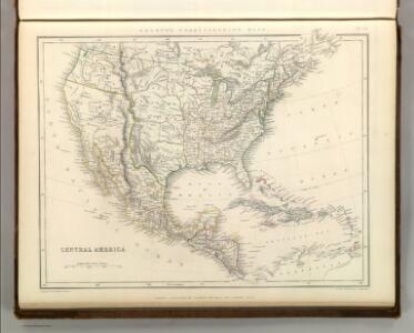
Maps of United States

Central America.
1 : 16600000 Sharpe, J.
Map of the United States of America, the British Provinces, Mexico, the West Indies and Central America, with part of New Granada and Venezuela
1 : 6400000 Colton, George Woolworth Colton, J. H. (Joseph Hutchins)
United States, Mexico, Central America, Caribbean.
1 : 1584000 Smith, J. Calvin
Map Of The United States The British Provinces Mexico &c.
1 : 14000000 Colton, J. H.
[Vereinigte Staaten von Nord-Amerika]
Hypsometrischer Atlas Ziegler, Jakob Melchior Topogr. Anstalt v. J. Wurster u. Comp.
Map of the United States of America, the British provinces, Mexico, the West Indies and Central America, with part of New Granada and Venezuela / map drawn by Geo. W. Colton ; engraved by John M. Atwood ; border desig'd. & eng'd. by W. S. Barnard.
From Parts
Map Of The United States Of America.
1 : 16526080 Colton, J. H.
Continental Map Of North America.
1 : 3041280 Monk, Jacob
Special -Karte der Vereinigten Staaten von Nord - America No 16.

Map Of The United States, Canada, Mexico, Central America, West Indies, &c.
1 : 3380000 Williams, G. Washington.
Standard American Map.
1 : 3168000 Monk, Jacob
Vereinigte Staaten, Central-Amerika und Westindien
Volksschul-Atlas über alle Teile der Erde Lange, Henry Druck und Verlag von Georg Westermann
America septentrionalis
1 Karte : Kupferdruck ; 45 x 53 cm Janssonius excudit Ioannes Janssonius
America septentrionalis
1 Karte : Kupferdruck ; 45 x 53 cm Valck; Schenk penes Gerardum Valk et Petrum Schenk
Pascaerte van Westindien : de vaste kusten en de Eylanden.
from De zee-atlas, ofte, Water-weereld : waer in vertoont werden alle de zee-kusten van het bekende des aerd-bodems : seer dienstigh voor alle heeren en kooplieden, als oock voor alle schippers en stuurlieden / gesneden, gedruckt en uytgegeven t'Amsteldam.
Map Of The United States, Canada, Mexico, Central America, and the West India Islands.
1 : 12500000 Atwood, J.M.
[Map of the United States, showing the proposed railroad routes from coast to coast, with table of distances, etc.]
from Whole s.n.: [N.Y.?],
New Map Of The Union.
1 : 6000000 Johnson, D. Griffing
A new map of the north parts of America claimed by France under ye names of Louisiana, Mississipi, Canada and New France, with ye adjoyning territories of England and Spain ... / ... laid down according to the newest and most exact observations by H. Mol
from The world described, or, A new and correct sett of maps : shewing the kingdoms and states in all the known parts of the earth, with the principal cities, and most considerable towns in the world ... / ... by Herman Moll, geographer ...
New National Map Exhibiting The United States
1 : 3800000 Mitchell, Samuel Augustus
Map Of The United States And Mexico.
1 : 3540000 Stanford, Edward
Verein-Staaten von Nord-America, Mexico, Yucatan u.A.
Hand-Atlas über alle Theile der Erde nach dem neuesten Zustande und über das Weltgebäude Stieler, Adolf bei Justus Perthes
Map of the United States of America, the British provinces, Mexico, the West Indies and Central America, with part of New Granada and Venezuela / map drawn by Geo. W. Colton ; engraved by John M. Atwood ; border desig'd. & eng'd. by W. S. Barnard.
from Parts
Our Country, Present & Prospective.
1 : 3801600 Gaston, Samuel N.
Composite: Amerique Septentrionale.
1 : 6300000 Anville, Jean Baptiste Bourguignon d, 1697-1782
Washington Map of the United States.
1 : 13000000 Taintor, S. & Co.
A new and correct map of North America with the West India Islands : divided according to the last Treaty of Peace, concluded at Paris the 20th of Jan. 1783, wherein are particularly distinguished the thirteen provinces wich [sic] compose the United Stat
from Charts and maps
Naval And Military Map Of The United States.
1 : 3300000 Smith, Robert P.
Map of the United States, British & Central America : from state documents & unpublished materials
1 : 3540000