Maps of United States

Map Of The United States, Canada, Mexico, Central America, and the West India Islands.
1 : 12500000 Atwood, J.M.
Map of the United States of America, the British provinces, Mexico, the West Indies and Central America, with part of New Granada and Venezuela / map drawn by Geo. W. Colton ; engraved by John M. Atwood ; border desig'd. & eng'd. by W. S. Barnard.
From Parts
[Vereinigte Staaten von Nord-Amerika]
Hypsometrischer Atlas Ziegler, Jakob Melchior Topogr. Anstalt v. J. Wurster u. Comp.
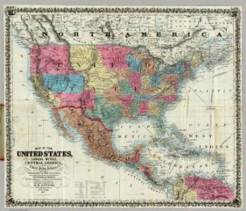
Map Of The United States, Canada, Mexico, Central America, West Indies, &c.
1 : 3380000 Williams, G. Washington.
Johnson's new illustrated & embellished county map of the republics of North America : with the adjacent islands & countries / compiled, drawn & engraved from U. States land & coast surveys, British Admiralty & other reliable sources by D. Griffing Johns
from Parts
Vereinigte Staaten, Central-Amerika und Westindien
Volksschul-Atlas über alle Teile der Erde Lange, Henry Druck und Verlag von Georg Westermann
United States, Mexico, Central America, Caribbean.
1 : 1584000 Smith, J. Calvin
A new map of the north parts of America claimed by France under ye names of Louisiana, Mississipi, Canada and New France, with ye adjoyning territories of England and Spain ... / ... laid down according to the newest and most exact observations by H. Mol
from The world described, or, A new and correct sett of maps : shewing the kingdoms and states in all the known parts of the earth, with the principal cities, and most considerable towns in the world ... / ... by Herman Moll, geographer ...
Special -Karte der Vereinigten Staaten von Nord - America No 16.

America septentrionalis
1 Karte : Kupferdruck ; 45 x 53 cm Janssonius excudit Ioannes Janssonius
America septentrionalis
1 Karte : Kupferdruck ; 45 x 53 cm Valck; Schenk penes Gerardum Valk et Petrum Schenk
Pascaerte van Westindien : de vaste kusten en de Eylanden.
from De zee-atlas, ofte, Water-weereld : waer in vertoont werden alle de zee-kusten van het bekende des aerd-bodems : seer dienstigh voor alle heeren en kooplieden, als oock voor alle schippers en stuurlieden / gesneden, gedruckt en uytgegeven t'Amsteldam.
Republics Of North America
1 : 3041280 Colton, J. H.
New Map Of The Union.
1 : 6000000 Johnson, D. Griffing
Our Country, Present & Prospective.
1 : 3801600 Gaston, Samuel N.
Central America.
1 : 16600000 Sharpe, J.
Map of the United States of America, the British provinces, Mexico, the West Indies and Central America, with part of New Granada and Venezuela / map drawn by Geo. W. Colton ; engraved by John M. Atwood ; border desig'd. & eng'd. by W. S. Barnard.
from Parts
North America / performed under the patronage of Louis Duke of Orleans, First Prince of the Blood by the Sieur d'Anville ; greatly improved by Mr. Bolton ; engrav,d by R. W. Seale ; Gravelot, delin. ; Walker, sculp.
from Charts and maps
Map Of The United States Of America.
1 : 16526080 Colton, J. H.
Verein-Staaten von Nord-America, Mexico, Yucatan u.A.
Hand-Atlas über alle Theile der Erde nach dem neuesten Zustande und über das Weltgebäude Stieler, Adolf bei Justus Perthes
Republics Of North America
1 : 3041280 Johnson, D. Griffing
New National Map Exhibiting The United States
1 : 3800000 Mitchell, Samuel Augustus
Map Of The United States The British Provinces Mexico &c.
1 : 14000000 Colton, J. H.
A new and correct map of North America with the West India Islands : divided according to the last Treaty of Peace, concluded at Paris the 20th of Jan. 1783, wherein are particularly distinguished the thirteen provinces wich [sic] compose the United Stat
from Charts and maps
America Septentrionalis.
from Whole Excudit Ioannes Ianssonius: Amstelodami; Jansson, Jan,
Map of the United States of America, the British Provinces, Mexico, the West Indies and Central America, with part of New Granada and Venezuela
1 : 6400000 Colton, George Woolworth Colton, J. H. (Joseph Hutchins)
North America / performed under the patronage of Louis Duke of Orleans, First Prince of the Blood by the Sieur d'Anville ; greatly improved by Mr. Bolton ; engrav,d by R. W. Seale ; Gravelot, delin. ; Walker, sculp.
from Whole
New National Map Exhibiting The United States
1 : 3800000 Mitchell, Samuel Augustus
Mitchell's new national map exhibiting the United States : with the north American British provinces, Sandwich Islands, Mexico and Central America, together with Cuba and other West India Islands
1 : 2500000 Williams, W. (Wellington) S. Augustus Mitchell