Maps of United States

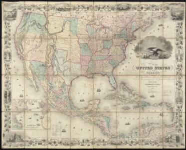
Map of the United States of America, the British Provinces, Mexico, the West Indies and Central America, with part of New Granada and Venezuela
1 : 6400000 Colton, George Woolworth Colton, J. H. (Joseph Hutchins)
Map Of The United States Of America.
1 : 16526080 Colton, J. H.
Central America.
1 : 16600000 Sharpe, J.
United States, Mexico, Central America, Caribbean.
1 : 1584000 Smith, J. Calvin
Map Of The United States The British Provinces Mexico &c.
1 : 14000000 Colton, J. H.
Map of the United States of America, the British provinces, Mexico, the West Indies and Central America, with part of New Granada and Venezuela / map drawn by Geo. W. Colton ; engraved by John M. Atwood ; border desig'd. & eng'd. by W. S. Barnard.
From Parts
[Map of the United States, showing the proposed railroad routes from coast to coast, with table of distances, etc.]
from Whole s.n.: [N.Y.?],
Vereinigte Staaten, Central-Amerika und Westindien
Volksschul-Atlas über alle Teile der Erde Lange, Henry Druck und Verlag von Georg Westermann
Map Of The United States, Canada, Mexico, Central America, West Indies, &c.
1 : 3380000 Williams, G. Washington.
[Vereinigte Staaten von Nord-Amerika]
Hypsometrischer Atlas Ziegler, Jakob Melchior Topogr. Anstalt v. J. Wurster u. Comp.
Our Country, Present & Prospective.
1 : 3801600 Gaston, Samuel N.
Washington Map of the United States.
1 : 13000000 Taintor, S. & Co.
Continental Map Of North America.
1 : 3041280 Monk, Jacob
Naval And Military Map Of The United States.
1 : 3300000 Smith, Robert P.
Special -Karte der Vereinigten Staaten von Nord - America No 16.

Diagram of the United States of America, Mexico, the West India Islands and Isthmus of Darien : showing proposed routes of the Pacific Rail Road ...
1 : 6500000 Steiger, W. T. United States. General Land Office
Standard American Map.
1 : 3168000 Monk, Jacob
America septentrionalis
1 Karte : Kupferdruck ; 45 x 53 cm Janssonius excudit Ioannes Janssonius
America septentrionalis
1 Karte : Kupferdruck ; 45 x 53 cm Valck; Schenk penes Gerardum Valk et Petrum Schenk
New National Map Exhibiting The United States
1 : 3800000 Mitchell, Samuel Augustus
Map Of The United States, Canada, Mexico, Central America, and the West India Islands.
1 : 12500000 Atwood, J.M.
Republics Of North America
1 : 3041280 Johnson, D. Griffing
Colton's Railroad and Military Map, United States.
1 : 6500000 Colton, G.W & C.B.
Pascaerte van Westindien : de vaste kusten en de Eylanden.
from De zee-atlas, ofte, Water-weereld : waer in vertoont werden alle de zee-kusten van het bekende des aerd-bodems : seer dienstigh voor alle heeren en kooplieden, als oock voor alle schippers en stuurlieden / gesneden, gedruckt en uytgegeven t'Amsteldam.
Our Country Present And Prospective.
1 : 3168000 Gaston, Samuel N.
New Map Of The Union.
1 : 6000000 Johnson, D. Griffing
New National Map Exhibiting The United States
1 : 3800000 Mitchell, Samuel Augustus
Verein-Staaten von Nord-America, Mexico, Yucatan u.A.
Hand-Atlas über alle Theile der Erde nach dem neuesten Zustande und über das Weltgebäude Stieler, Adolf bei Justus Perthes
Map Of The United States And Mexico.
1 : 3540000 Stanford, Edward