Maps of United States

Special -Karte der Vereinigten Staaten von Nord - America No 16.

Continental Map Of North America.
1 : 3041280 Monk, Jacob
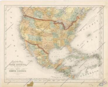
Map of the United States of America, the British provinces, Mexico, the West Indies and Central America, with part of New Granada and Venezuela / map drawn by Geo. W. Colton ; engraved by John M. Atwood ; border desig'd. & eng'd. by W. S. Barnard.
from Parts
Standard American Map.
1 : 3168000 Monk, Jacob
United States, Mexico, Central America, Caribbean.
1 : 1584000 Smith, J. Calvin
[Vereinigte Staaten von Nord-Amerika]
Hypsometrischer Atlas Ziegler, Jakob Melchior Topogr. Anstalt v. J. Wurster u. Comp.
Charte von Nord-America
1 : 20500000 Severní Amerika
CHARTE von NORD-AMERICA
1 : 20500000 Severní Amerika
A new and correct map of North America with the West India Islands : divided according to the last treaty of peace, concluded at Paris, 10th Feby. 1763 ; wherein are particularly distinguished, the several provinces and colonies, which compose the Britis
from Whole
Map Of The United States The British Provinces Mexico &c.
1 : 14000000 Colton, J. H.
Charte von Nordamerica
1 Karte : Kupferdruck ; 57 x 50 cm Reichard im Verlage des Industrie Comptoirs
America septentrionalis
Severní Amerika Janssonius, Johannes excudit Ioannes Ianßonius
Map of the United States of America, the British provinces, Mexico, the West Indies and Central America, with part of New Granada and Venezuela / map drawn by Geo. W. Colton ; engraved by John M. Atwood ; border desig'd. & eng'd. by W. S. Barnard.
From Parts
A new and correct map of North America with the West India Islands : divided according to the last Treaty of Peace, concluded at Paris the 20th of Jan. 1783, wherein are particularly distinguished the thirteen provinces wich [sic] compose the United Stat
from Charts and maps
A map of North America with the European settlements & whatever else is remarkable in ye West Indies from the latest and best observations / R.W. Seale delin. et sculp.
from Whole R.W. Seale,
America, about 1670.
1 : 65000000 Wit, Frederik de
Map of The United States, and Territories. Together with Canada & c. ; Island of Newfoundland
from Atlas of Schuyler County, New York : from actual surveys by and under the direction of Beach Nichols.
An accurate map of the British, French & Spanish settlements in Nth. America and the West Indies: as stipulated by the preliminary articles of peace sign'd at Fontainebleau by the ministers of Great Britain, France & Spain, Novr. 3d, 1762. / J. Gibson sculp.
from Whole Payne, John; Gibson, John,
Nord-America
Hand-Atlas über alle Theile der Erde und über das Weltgebäude Stieler, Adolf Justus Perthes
Ethnographische Karte von Nordamerika
Zweiter Band, enthaltend in vier Abtheilungen die Vertheilung der Organismen: 5. Pflanzen-Geographie, 6. Thier-Geographie, 7. Anthropographie, 8. Ethnographie Humboldt, Alexander von Verlag von Justus Perthes
Sewerní Amerika.
L'America settentrionale
Severní Amerika Sanson, Guillaume De Rossi, Giovanni Giacomo Gio. Giacomo de Rossi
Soubor němých map pro gymnasia a odborné školy

North America / performed under the patronage of Louis Duke of Orleans, First Prince of the Blood by the Sieur d'Anville ; greatly improved by Mr. Bolton ; engrav,d by R. W. Seale ; Gravelot, delin. ; Walker, sculp.
from Whole
A map of North America: with the European settlements & whatever else is remarkable in ye West Indies, from the latest and best observations / R.W. Seale, delin. et sculp.
from Whole R.W. Seale,
Central America.
1 : 16600000 Sharpe, J.
America Septentrionalis.
from Whole Excudit Ioannes Ianssonius: Amstelodami; Jansson, Jan,
Map of The United States
from Atlas of Wayne County, New York : from actual surveys and official records / compiled & published by D. G. Beers & Co.
Map Of The United States, Canada, Mexico, Central America, and the West India Islands.
1 : 12500000 Atwood, J.M.