Maps of United States

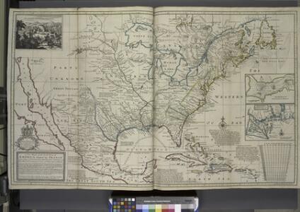
A new map of the north parts of America claimed by France under ye names of Louisiana, Mississipi, Canada and New France, with ye adjoyning territories of England and Spain ... / ... laid down according to the newest and most exact observations by H. Mol
from The world described, or, A new and correct sett of maps : shewing the kingdoms and states in all the known parts of the earth, with the principal cities, and most considerable towns in the world ... / ... by Herman Moll, geographer ...
Map of the United States of America, the British provinces, Mexico, the West Indies and Central America, with part of New Granada and Venezuela / map drawn by Geo. W. Colton ; engraved by John M. Atwood ; border desig'd. & eng'd. by W. S. Barnard.
From Parts
[Vereinigte Staaten von Nord-Amerika]
Hypsometrischer Atlas Ziegler, Jakob Melchior Topogr. Anstalt v. J. Wurster u. Comp.
America septentrionalis
1 Karte : Kupferdruck ; 45 x 53 cm Janssonius excudit Ioannes Janssonius
America septentrionalis
1 Karte : Kupferdruck ; 45 x 53 cm Valck; Schenk penes Gerardum Valk et Petrum Schenk
North America / performed under the patronage of Louis Duke of Orleans, First Prince of the Blood by the Sieur d'Anville ; greatly improved by Mr. Bolton ; engrav,d by R. W. Seale ; Gravelot, delin. ; Walker, sculp.
from Whole
America Septentrionalis.
from Whole Excudit Ioannes Ianssonius: Amstelodami; Jansson, Jan,
Regni Mexicani seu Novae Hispaniae, Floridae, Novae Angliae, Carolinae, Virginiae et Pensylvaniae necnon insularum archipelagi Mexicani in America Septentrionali
from Charts and maps
Pascaerte van Westindien : de vaste kusten en de Eylanden.
from De zee-atlas, ofte, Water-weereld : waer in vertoont werden alle de zee-kusten van het bekende des aerd-bodems : seer dienstigh voor alle heeren en kooplieden, als oock voor alle schippers en stuurlieden / gesneden, gedruckt en uytgegeven t'Amsteldam.
New Map Of The Union.
1 : 6000000 Johnson, D. Griffing
A New map of North America with the West India Islands : divided according to the preliminary articles of peace, signed at Versailles, 20, Jan. 1783, wherein are particularly distinguished the United States, and the several provinces, governments &ca
from Whole
Map of the United States of America, the British provinces, Mexico, the West Indies and Central America, with part of New Granada and Venezuela / map drawn by Geo. W. Colton ; engraved by John M. Atwood ; border desig'd. & eng'd. by W. S. Barnard.
from Parts
North America / performed under the patronage of Louis Duke of Orleans, First Prince of the Blood by the Sieur d'Anville ; greatly improved by Mr. Bolton ; engrav,d by R. W. Seale ; Gravelot, delin. ; Walker, sculp.
from Charts and maps
America Septentrionalis. [Karte], in: Novus atlas absolutissimus, Bd. 6, S. 197.
1 Karte aus Atlas Janssonius Offizin
Composite: North America.
1 : 5400000 Jefferys, Thomas
A new and correct map of North America with the West India Islands : divided according to the last Treaty of Peace, concluded at Paris the 20th of Jan. 1783, wherein are particularly distinguished the thirteen provinces wich [sic] compose the United Stat
from Charts and maps
Map of the United States of America, the British provinces, Mexico, the West Indies and Central America, with part of New Granada and Venezuela / map drawn by Geo. W. Colton; engraved by John M. Atwood; border desig'd. & eng'd. by W.S. Barnard.
from Parts George W. Colton; John M. Atwood; W. S. Barnard,
Composite: Amerique Septentrionale.
1 : 6300000 Anville, Jean Baptiste Bourguignon d, 1697-1782
United States, Mexico, Central America, Caribbean.
1 : 1584000 Smith, J. Calvin
Map Of The United States, Canada, Mexico, Central America, and the West India Islands.
1 : 12500000 Atwood, J.M.
Special -Karte der Vereinigten Staaten von Nord - America No 16.

A new and correct map of North America with the West India Islands : divided according to the last treaty of peace, concluded at Paris, 10th Feby. 1763 ; wherein are particularly distinguished, the several provinces and colonies, which compose the Britis
from Whole
A new map of North America with the West India Islands: divided according to the preliminary articles of peace, signed at Versailles, 20, Jan. 1783; wherein are particularly distinguished the United States and the several provinces, governments & ca. which compose the British dominions / laid down according to the latest surveys and corrected from the original materials of Goverr. Pownall, Membr. of Parliamt., 1783.
from Charts and maps Governor Pownall,
Regni Mexicani seu Novae Hispaniae, Ludovicianae, N. Angliae, Carolinae, Virginiae, Pensylvaniae, ... in America Septentrionali
from John H. Levine Collection
Composite: North America.
1 : 5400000 Robert Laurie & James Whittle
L'Amerique septentrionale
1 : 16000000 dressée sur les observations de Mrs. de l'Academie Royale des Sciences & quelques autres, & sur les memoires les plus recens [...] par G. de l'Isle A Amsterdam : chez J. Cóvens & C. Mortier
Central America.
1 : 16600000 Sharpe, J.
America septentrionalis
1 : 18800000 Severní Amerika Delisle, Guillaume Lotter, Georg F. apud Tobiam Conr. Lotter
America septentrionalis
1 : 18800000 Severní Amerika Delisle, Guillaume Lotter, Georg F. apud Tobiam Conr. Lotter
America septentrionalis
1 : 18800000 Severní Amerika Delisle, Guillaume Lotter, Georg F. apud Tobiam Conr. Lotter