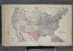
Maps of United States

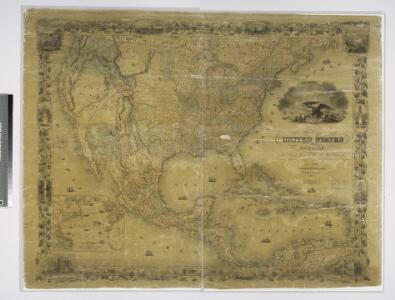
Map of the United States of America, the British provinces, Mexico, the West Indies and Central America, with part of New Granada and Venezuela / map drawn by Geo. W. Colton ; engraved by John M. Atwood ; border desig'd. & eng'd. by W. S. Barnard.
from Parts
A new and correct map of North America with the West India Islands : divided according to the last Treaty of Peace, concluded at Paris the 20th of Jan. 1783, wherein are particularly distinguished the thirteen provinces wich [sic] compose the United Stat
from Charts and maps
A new and correct map of North America with the West India Islands : divided according to the last treaty of peace, concluded at Paris, 10th Feby. 1763 ; wherein are particularly distinguished, the several provinces and colonies, which compose the Britis
from Whole
Nord-America
Hand-Atlas über alle Theile der Erde und über das Weltgebäude Stieler, Adolf Justus Perthes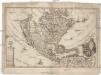
America borealis
1 : 32500000 Severní Amerika Scherer, Heinrich
Special -Karte der Vereinigten Staaten von Nord - America No 16.

Nord America
1 : 16000000 entworfen und gezeichnet von C. F. Weiland gest. v. C. Jungmann Weimar : im Verlage des Geograph. Instituts
A map of North America with the European settlements & whatever else is remarkable in ye West Indies from the latest and best observations / R.W. Seale delin. et sculp.
from Whole R.W. Seale,
Nordamerica
Neuester Schul-Atlas Walch, Johann im Verlag bei Joh. Walch
America septentrionalis
Severní Amerika Janssonius, Johannes excudit Ioannes Ianßonius
An accurate map of the British, French & Spanish settlements in Nth. America and the West Indies: as stipulated by the preliminary articles of peace sign'd at Fontainebleau by the ministers of Great Britain, France & Spain, Novr. 3d, 1762. / J. Gibson sculp.
from Whole Payne, John; Gibson, John,
Ethnographische Karte von Nordamerika
Zweiter Band, enthaltend in vier Abtheilungen die Vertheilung der Organismen: 5. Pflanzen-Geographie, 6. Thier-Geographie, 7. Anthropographie, 8. Ethnographie Humboldt, Alexander von Verlag von Justus Perthes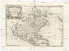
L'America settentrionale
Severní Amerika Sanson, Guillaume De Rossi, Giovanni Giacomo Gio. Giacomo de Rossi
America, about 1670.
1 : 65000000 Wit, Frederik de
A New map of North America with the West India Islands : divided according to the preliminary articles of peace, signed at Versailles, 20, Jan. 1783, wherein are particularly distinguished the United States, and the several provinces, governments &ca
from Whole
Charte von Nord-America
1 : 20500000 Severní Amerika
CHARTE von NORD-AMERICA
1 : 20500000 Severní Amerika
Standard American Map.
1 : 3168000 Monk, Jacob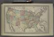
Map of The United States
from Atlas of Wayne County, New York : from actual surveys and official records / compiled & published by D. G. Beers & Co.
[Vereinigte Staaten von Nord-Amerika]
Hypsometrischer Atlas Ziegler, Jakob Melchior Topogr. Anstalt v. J. Wurster u. Comp.
Sewerní Amerika.

America Septentrionalis. [Karte], in: Novus atlas absolutissimus, Bd. 6, S. 197.
1 Karte aus Atlas Janssonius Offizin
Continental Map Of North America.
1 : 3041280 Monk, Jacob
A map of North America: with the European settlements & whatever else is remarkable in ye West Indies, from the latest and best observations / R.W. Seale, delin. et sculp.
from Whole R.W. Seale,
America septentrionalis
1 : 18800000 Severní Amerika Delisle, Guillaume Lotter, Georg F. apud Tobiam Conr. Lotter
America septentrionalis
1 : 18800000 Severní Amerika Delisle, Guillaume Lotter, Georg F. apud Tobiam Conr. Lotter
America septentrionalis
1 : 18800000 Severní Amerika Delisle, Guillaume Lotter, Georg F. apud Tobiam Conr. Lotter
America septentrionalis
1 : 20000000 Severní Amerika Delisle, Guillaume Lotter, Georg F. T. C. Lotter
Map of the United States of America, the British provinces, Mexico, the West Indies and Central America, with part of New Granada and Venezuela / map drawn by Geo. W. Colton ; engraved by John M. Atwood ; border desig'd. & eng'd. by W. S. Barnard.
From Parts