Maps of Poland

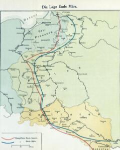
Die Lage Ende März
Polen Weltkrieg <1914-1918>, Ostfront
Východní fronta 1914

Republika Polská

Charte von Polen
1 : 2320000 Halič (Polsko a Ukrajina) bey Artaria
Charte von Polen
1 : 2320000 Halič (Polsko a Ukrajina) bey Artaria
Charte von Polen
1 : 2320000 Halič (Polsko a Ukrajina) Artaria
Nr. 15. Der Krieg in Westrußland im Herbst 1915
Polen Weltkrieg <1914-1918>, Ostfront
Republika polská
1 : 1000000 Bělorusko
Deutsch-österreich-russische Grenze
Polen Grenze
Poland, 1:2,000,000
1 : 2000000
Östlicher Kriegsschauplatz I
1 : 5000000 Ostmitteleuropa Weltkrieg <1914-1918>, Ostfront
Pologne.
1 : 2850000 Clouet, J. B. L. (Jean-Baptiste Louis), b. 1730
Ethnographical map (Eastern Europe). Poland 1918
1 : 1500000 First World War ethnographical map (Eastern Europe). 1918. Four sheets, covering Germany, Poland, Northern Italy and South eastern Europe. To illustrate the post-WW1 settlement. War Office
Nr. 18b. Hindenburgs Züge
Polen Weltkrieg <1914-1918>, Ostfront
Feuille 25 (D IV), uit: Carte géologique internationale de l'Europe : la carte, votée au congrès géologique international de Bologne en 1881, est exécutée conformément aux décisions d'une commission internationale, avec le concours des gouvernements, sous le dir. de M.M. Beyrich et Hauchecorne
Annotatie: Blad 48 gamme des couleurs; blad 49: bladwijzer en titelblad Heinrich Ernst Beyrich 1815-1896; Wi. Hauchecorne Berlin : Reimer / (Berlin: Institut lithographique)
Plastická mapa zemí Sudetských a Karpatských
Evropa střední E. Šolc
Carte géologique de la République Polonaise
1 : 2500000 Kuźniar, Czesław; (Pologne) Service Géologique Lwów : Service Géologique de Pologne
Poland & Czecho-Slovakia.
1 : 2000000 John Bartholomew and Son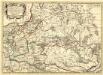
Germano - Sarmatia in qua Populi maiores Venedi et Aestiaei Peucini et Bastarnae in minores Populos divisi ad hodiernam locorum, et Redionum positionem respondent
1 : 2900000 Mollova mapová sbírka Sanson, Nicolas Covens, Johannes I
Weichsel
Weichsel (Fluss), Flusslauf
Chelm und Podlachien
Polen Chełm (Województwo) Podlachien Auner, H.
Befestigungen in West-Rußland
Russland Russland (West) Befestigung Militär
Carte du Royaume de Pologne
1 : 900000 Bělorusko Nordmann, A. P. H. Gilly Artaria
Superficie de petites exploitations privées (au-dessous de 50 ha) en proportions pour cent de la superficie générale
1 : 5000000 Polsko w Biurze kartograficznem
Východní fronta 1914

Západní Rusko a přilehlé části říše Německé a Rakousko-Uherska
1 : 1250000 Německo východní Machát, František nákladem uměleckého ústavu grafického V. Neuberta
Russische Gouvernementseinteilung vor der deutschen Besatzung
Baltikum Kurland (Gouvernement) Ėstljandskaja Gubernija Riga (Gouvernement)
Východní fronta 1914

Charte von Ost- und West- Galicien
1 : 1250000 Halič (Polsko a Ukrajina) Mannert, Conrad in Verlag der k. privil. Schneider u. Weigelschen Kunst- und Buchhandlung