Maps of Belarus

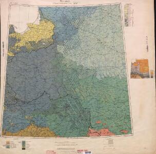
Ethnographical map (Eastern Europe). Poland 1918
1 : 1500000 First World War ethnographical map (Eastern Europe). 1918. Four sheets, covering Germany, Poland, Northern Italy and South eastern Europe. To illustrate the post-WW1 settlement. War Office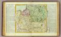
Pologne.
1 : 2850000 Clouet, J. B. L. (Jean-Baptiste Louis), b. 1730
Polen
1 : 1280000 Bělorusko Rizzi Zannoni, Giovanni Antonio Artaria
Polen
1 : 1280000 Bělorusko Rizzi Zannoni, Giovanni Antonio Artaria
Carte Generale du Royaume de Polonge.
1 : 4400000 Vivien de St Martin, L.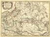
Germano - Sarmatia in qua Populi maiores Venedi et Aestiaei Peucini et Bastarnae in minores Populos divisi ad hodiernam locorum, et Redionum positionem respondent
1 : 2900000 Mollova mapová sbírka Sanson, Nicolas Covens, Johannes I
Generalkarte von Polen, Litauen und den angraenzenden Laendern
1 : 1250000 Litva Follin, Bartolomeo F.A. Schraembl
Karta voennych dějstvīj 1768 - 1771 i 1794 g.g.
Polen Krieg
Das Königreich Pohlen und Grosherzogthum Litthauen
Litva
Neueste karte von Polen und Lithauen nebst Theilen der angränzenden Länder
Litva C. Hoffmann
Polens Umwandelungen von 1772-1809
1 : 2100000 Polsko zu finden in der Dykischen Buchhandlung
Dritte Theilung Polens 1795
Polen Teilung Polens <1795>
Het Koningkryk Polen, volgens de nieuwste waarneminge opgesteld
1 : 16000000 te Amsterdam : bij S. v. Esveldt
Generalkarte von Polen, Litauen und den angrenzenden Ländern
Polen-Litauen Schraembl, Franz Anton
Charte vom Koenigreich Polen
1 : 2090000 Bělorusko Hutter, F. X. Walch, Johann bey Joh. Walch
Západní Rusko a přilehlé části říše Německé a Rakousko-Uherska
1 : 1250000 Německo východní Machát, František V. Neubert
Kriegskarte des Koenigreichs Polen, nach den bewährtesten Hülfmitteln und den Theilungs-Tractaten vom Jahre 1773 und 1793 entworfen
1 : 2250000 entw. u. gest. von F. X. Hutter Augsburg : zu haben bey Joh. Walch
Polen vor der Theilung
1 : 1800000 Polsko Goldschmidt Goldschmidt
Dritte Theilung Polens 1795
Polen Teilung Polens <1795>
Paasche's Frontenkarte, Nr.6. Der Krieg gegen Russland

Mapa Polski
1 : 1500000 Evropa střední a východní Pokorny, Wilhelm Tomaszewski, Adam Księgarnia polska Bernarda Połonieckiego
Polen
1 : 2100000 Bělorusko Hutter, F. X. Walch, Johann bey Joh. Walch
Polens Umwandelungen von 1772-1809
1 : 2100000 Bělorusko in der Dykischen Buchhandlung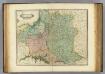
Poland, Lithuania
1 : 2650000 Lizars, Daniel
Befestigungen in West-Rußland
Russland Russland (West) Befestigung Militär
Nova descriptio regni Poloniae et magni ducatus Lithuaniae
1 : 6600000 Litva
Zweite Theilung Polens 1793
Polen Teilung Polens <1793>
Erste Theilung Polens 1772
Polen Teilung Polens <1772>
Zweite Theilung Polens 1793
Polen Teilung Polens <1793>