Maps of Slovakia

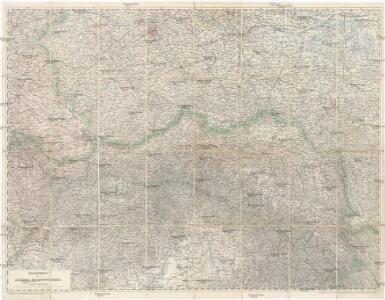
Übersichtskarte des nördlichen Kriegsschauplatzes
1 : 750000 Polsko k. u. k. Hof- und Universitätsbuchhandlung R. Lechner (W. Müller)
Charte vom Königreiche Galizien
1 : 2000000 Halič (Polsko a Ukrajina) Kipferling, Karl Joseph Kunst und Industrie Comptoirs
Charte vom Königreiche Galizien
Halič (Polsko a Ukrajina) Kipferling, Karl Joseph Walch, Johann in J. Riedl's Kunsthandlung
Východní fronta 1914

Charte von Ost- und West- Galicien
1 : 1250000 Halič (Polsko a Ukrajina) Mannert, Conrad in Verlag der k. privil. Schneider u. Weigelschen Kunst- und Buchhandlung
Východní fronta 1914

Postkarte vom östlichen und westlichen Galizien
Halič (Polsko a Ukrajina) Ponheimer, Kilian im von Reilly'schen Landkarten und Kunstwerke Verschleiss Komptoir
Charte von Ost und West Galizien
1 : 1250000 Halič (Polsko a Ukrajina) Schmidburg, G. R. im Verlage des Industrie Comptoirs
Charte von Galizien / gezeichnet von G.R. v. Schmidburg
1 : 1200000 1 Karte : Kupferdruck ; 47 x 60 cm Schmidburg, Georg Rudolph von Verlag des Geogr. Instituts
Übersichtskarte des russischen Kriegsschauplatzes
1 : 750000 Evropa východní k. u. k. Hof- und Universitätsbuchhandlung R. Lechner (W. Müller)
Die Lage Ende März
Polen Weltkrieg <1914-1918>, Ostfront
Východní fronta 1914

Reliefkarte von Galizien und Süd-Polen

Carte Nouvelle des Royaumes de Galizie et Lodomerie, avec le District de Bukowine.
From Poland
Charte von Galizien, oesterreichisch und russischen Antheils
1 : 1100000 Halič (Polsko a Ukrajina) Streit, Friedrich Wilhelm Engelhardt, F. B. im Verlage des geographischen Instituts
Karte des Oesterreichisch - ungarischen Reiches

Přehledná letecká mapa republiky Československé

Einteilung der Grenzwache an der österr. Grenze
Russland Österreich-Ungarn Grenze Militär
Das Königreich Galizien u. Lodomerien mit d. Grossherzogth. Krakau, das Herzogth. Bukovina
Bukovina (Rumunsko a Ukrajina) Ignaz Fuchs
Mapa powierzchni szczytowej Karpat i ich przedmurza = Carte de la surface des faîtes des Karpates et de leur avant pays
1 : 1000000 Teisseyre, Henryk Lwow ; Warszawa : Ksiaznica-Atlas
Zuid Gouv.Gen., Slowakije en Hongarije
1 : 3000000 Den Haag : Kompas
Západní Rusko a přilehlé části říše Německé a Rakousko-Uherska
1 : 1250000 Německo východní Machát, František nákladem uměleckého ústavu grafického V. Neuberta
Le Royaume de Hongrie
Sbírka map a diagramů použitých na mírových konferencích v Paříži v letech 1919 - 1920
Železniční mapa Československé republiky
1 : 850000 Bratislava (Slovensko : oblast) Kopal, K. Klos, J. Ministerstvo železnic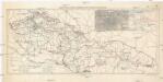
Carte des Voies Ferrées de Tchécoslovaque
1 : 1250000 Evropa Vojenský zeměpisný ústav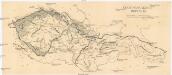
Čechoslovakische Republik
Československo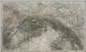
Composite III, IV, V, VIII, IX, X: Karte Des Oesterreichischen Kaiserstaates.
1 : 576000 Scheda, Josef