Maps of Poland

Východní fronta 1914

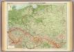
Republika Polská

Nr. 15. Der Krieg in Westrußland im Herbst 1915
Polen Weltkrieg <1914-1918>, Ostfront
Östlicher Kriegsschauplatz I
1 : 5000000 Ostmitteleuropa Weltkrieg <1914-1918>, Ostfront
Ethnographical map (Eastern Europe). Poland 1918
1 : 1500000 First World War ethnographical map (Eastern Europe). 1918. Four sheets, covering Germany, Poland, Northern Italy and South eastern Europe. To illustrate the post-WW1 settlement. War Office
Republika polská
1 : 1000000 Bělorusko
Feuille 25 (D IV), uit: Carte géologique internationale de l'Europe : la carte, votée au congrès géologique international de Bologne en 1881, est exécutée conformément aux décisions d'une commission internationale, avec le concours des gouvernements, sous le dir. de M.M. Beyrich et Hauchecorne
Annotatie: Blad 48 gamme des couleurs; blad 49: bladwijzer en titelblad Heinrich Ernst Beyrich 1815-1896; Wi. Hauchecorne Berlin : Reimer / (Berlin: Institut lithographique)
Übersichtskarte des Östlichen Kriegsschauplatzes
1 : 4500000 Osteuropa Polen Litauen Weißrussland Galizien und Lodomerien Weltkrieg <1914-1918> Verl. Gerhard Stalling, Oldenburg
Carte géologique de la République Polonaise
1 : 2500000 Kuźniar, Czesław; (Pologne) Service Géologique Lwów : Service Géologique de Pologne
Die Lage Ende März
Polen Weltkrieg <1914-1918>, Ostfront
Polen
1 : 1280000 Bělorusko Rizzi Zannoni, Giovanni Antonio Artaria
Polen
1 : 1280000 Bělorusko Rizzi Zannoni, Giovanni Antonio Artaria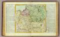
Pologne.
1 : 2850000 Clouet, J. B. L. (Jean-Baptiste Louis), b. 1730
Generalkarte von Polen, Litauen und den angraenzenden Laendern
1 : 1250000 Litva Follin, Bartolomeo F.A. Schraembl
Polen
1 : 2100000 Bělorusko Hutter, F. X. Walch, Johann bey Joh. Walch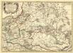
Germano - Sarmatia in qua Populi maiores Venedi et Aestiaei Peucini et Bastarnae in minores Populos divisi ad hodiernam locorum, et Redionum positionem respondent
1 : 2900000 Mollova mapová sbírka Sanson, Nicolas Covens, Johannes I
Carte Generale du Royaume de Polonge.
1 : 4400000 Vivien de St Martin, L.
Deutsch-österreich-russische Grenze
Polen Grenze
Západní Rusko a přilehlé části říše Německé a Rakousko-Uherska
1 : 1250000 Německo východní Machát, František V. Neubert
Das Königreich Pohlen und Grosherzogthum Litthauen
Litva
Charte von Polen
1 : 2320000 Halič (Polsko a Ukrajina) bey Artaria
Charte von Polen
1 : 2320000 Halič (Polsko a Ukrajina) bey Artaria
Charte von Polen
1 : 2320000 Halič (Polsko a Ukrajina) Artaria
Karta voennych dějstvīj 1768 - 1771 i 1794 g.g.
Polen Krieg
Poland.
1 : 3576320 Cummins Map Co.
Russische Gouvernementseinteilung vor der deutschen Besatzung
Baltikum Kurland (Gouvernement) Ėstljandskaja Gubernija Riga (Gouvernement)
Carte ethnographique des Russes, Polonais et Luthuaniens
1 : 1680000 Litva Florinskij, Timofej Dmitrijevič
Poland, 1:2,000,000
1 : 2000000
Befestigungen in West-Rußland
Russland Russland (West) Befestigung Militär