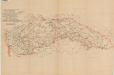
Maps of Carpathian Mountains

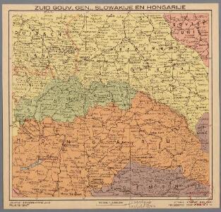
Zuid Gouv.Gen., Slowakije en Hongarije
1 : 3000000 Den Haag : Kompas
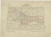
Le Royaume de Hongrie
Atlas d'industrie de la république tchécoslovaque

Karte des Oesterreichisch - ungarischen Reiches
Atlas d'industrie de la république tchécoslovaque
Přehled listů mapy generální 1:200 000, speciální 1:75 000 a původního vyměřování (topogr. sekcí) 1:25 000

Galizien, Nord Ungarn und ein Theil von Siebenbürgen
1 : 1863880 Druck u. Verlag von C. Flemming
Československo v mapách

Neűe und richtige abbildung deß gantzen Königreichs Ungern sampt denen daran stossenden Ländern Bey der zugleich heraußgegebenen neuen und kurtzen beschreibung dieses Königreichs nützlich zu gebrauchen
1 : 1200000 Mollova mapová sbírka Pfann, Wilhelm Hofmann, Johann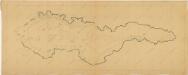
Bez titulu: Československo

Postkarte vom östlichen und westlichen Galizien
Halič (Polsko a Ukrajina) Ponheimer, Kilian im von Reilly'schen Landkarten und Kunstwerke Verschleiss Komptoir
Atlas d'industrie de la république tchécoslovaque

Carte Nouvelle des Royaumes de Galizie et Lodomerie, avec le District de Bukowine.
From Poland
Přehledná letecká mapa republiky Československé

Galizien, Nord-Ungarn, Siebenburgen.
1 : 1863880 Flemming, Carl
Sbírka map a diagramů použitých na mírových konferencích v Paříži v letech 1919 - 1920
Sbírka map a diagramů použitých na mírových konferencích v Paříži v letech 1919 - 1920

VII, uit: General-Karte von Mittel-Europa in 12 Blättern, im Masse 1:1.200.000 / entworfen, bearb. und hrsg. von Josef Schlacher
1 : 1200000 Annotatie: Blad 6 ontbreekt; Annotatie geografische gegevens: 21 maatstokken op blad 9; Legenda op blad 9 Wien : K.K. Militär Geografisches Institut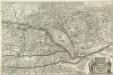
Neue Land Tafel von Hungarn
1 : 1100000 Mollova mapová sbírka Sandrart, Jakob von Sandrart, Jacob von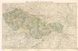
Mapa republiky Československé

[Russischer Vormarsch auf Budapest]
Ungarn Militärische Planung, Strategische Offensive
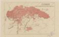
Mapa powierzchni szczytowej Karpat i ich przedmurza = Carte de la surface des faîtes des Karpates et de leur avant pays
1 : 1000000 Teisseyre, Henryk Lwow ; Warszawa : Ksiaznica-Atlas
Composite III, IV, V, VIII, IX, X: Karte Des Oesterreichischen Kaiserstaates.
1 : 576000 Scheda, Josef
Charte vom Königreiche Galizien
1 : 2000000 Halič (Polsko a Ukrajina) Kipferling, Karl Joseph Kunst und Industrie Comptoirs
Charte vom Königreiche Galizien
Halič (Polsko a Ukrajina) Kipferling, Karl Joseph Walch, Johann in J. Riedl's Kunsthandlung
[Österreich-Ungarn, Blatt 2]
Adolf Stieler's Handatlas über alle Theile der Erde und über das Weltgebäude Stieler, Adolf Justus Perthes
General- Post- und Strassen Karte des Königreich Galizien
1 : 871000 Halič (Polsko a Ukrajina) Schulz, R. A. Artaria
Totius Regni Hungariae una cum Adjacentibus et finitimis Regionibus Delineatio
Mollova mapová sbírka Visscher, Nicolaes Visscher, Nicolaus
[Uhersko]
1 : 3400000 Uhersko Wagner, Johann Christoph J. Ch. Wagners