Maps of Poland

Republika polská
1 : 1000000 Bělorusko
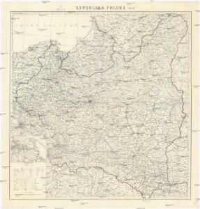
Republika Polská

Feuille 25 (D IV), uit: Carte géologique internationale de l'Europe : la carte, votée au congrès géologique international de Bologne en 1881, est exécutée conformément aux décisions d'une commission internationale, avec le concours des gouvernements, sous le dir. de M.M. Beyrich et Hauchecorne
Annotatie: Blad 48 gamme des couleurs; blad 49: bladwijzer en titelblad Heinrich Ernst Beyrich 1815-1896; Wi. Hauchecorne Berlin : Reimer / (Berlin: Institut lithographique)
Carte géologique de la République Polonaise
1 : 2500000 Kuźniar, Czesław; (Pologne) Service Géologique Lwów : Service Géologique de Pologne
Polen
1 : 2100000 Bělorusko Hutter, F. X. Walch, Johann bey Joh. Walch
Charte von Polen
1 : 2320000 Halič (Polsko a Ukrajina) bey Artaria
Charte von Polen
1 : 2320000 Halič (Polsko a Ukrajina) bey Artaria
Charte von Polen
1 : 2320000 Halič (Polsko a Ukrajina) Artaria
Übersichtskarte des Östlichen Kriegsschauplatzes
1 : 4500000 Osteuropa Polen Litauen Weißrussland Galizien und Lodomerien Weltkrieg <1914-1918> Verl. Gerhard Stalling, Oldenburg
Nr. 15. Der Krieg in Westrußland im Herbst 1915
Polen Weltkrieg <1914-1918>, Ostfront
Východní fronta 1914

Deutsch-österreich-russische Grenze
Polen Grenze
Polonia
Polsko
Charte vom Koenigreich Polen
1 : 2090000 Bělorusko Hutter, F. X. Walch, Johann bey Joh. Walch
Polen im Herzogthum Warschau und unter Oestreich und Russland getheilt
1 : 2080000 Bělorusko Mollo, Tranquillo bey T. Mollo
Poland, Lithuania
1 : 2650000 Lizars, Daniel
Kriegskarte des Koenigreichs Polen, nach den bewährtesten Hülfmitteln und den Theilungs-Tractaten vom Jahre 1773 und 1793 entworfen
1 : 2250000 entw. u. gest. von F. X. Hutter Augsburg : zu haben bey Joh. Walch
Carte Generale du Royaume de Polonge.
1 : 4400000 Vivien de St Martin, L.
Polen
1 : 1280000 Bělorusko Rizzi Zannoni, Giovanni Antonio Artaria
Polen
1 : 1280000 Bělorusko Rizzi Zannoni, Giovanni Antonio Artaria
Mapa Polski
1 : 1500000 Evropa střední a východní Pokorny, Wilhelm Tomaszewski, Adam Księgarnia polska Bernarda Połonieckiego
Poland, 1:2,000,000
1 : 2000000
Generalkarte von Polen, Litauen und den angrenzenden Ländern
Polen-Litauen Schraembl, Franz Anton
Nr. 18b. Hindenburgs Züge
Polen Weltkrieg <1914-1918>, Ostfront
Dritte Theilung Polens 1795
Polen Teilung Polens <1795>
Preussen, Polen, Galizien, Ungarn, Siebenbürgen
Schul-Atlas über alle Theile der Erde nach dem neuesten Zustande, und über das Weltgebäude Stieler, Adolf bei Justus Perthes
Preussen, Polen, Galizen, Ungarn, Siebenbuergen
Ostmitteleuropa
Poland.
1 : 3576320 Cummins Map Co.
Poland, Prussia.
1 : 4400000 Darton, William