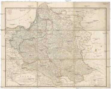
Maps of Poland

Charte von Polen
1 : 2320000 Halič (Polsko a Ukrajina) bey Artaria
Charte von Polen
1 : 2320000 Halič (Polsko a Ukrajina) bey Artaria
Charte von Polen
1 : 2320000 Halič (Polsko a Ukrajina) Artaria
Republika polská
1 : 1000000 Bělorusko
Carte Generale du Royaume de Polonge.
1 : 4400000 Vivien de St Martin, L.
Carte ethnographique des Russes, Polonais et Luthuaniens
1 : 1680000 Litva Florinskij, Timofej Dmitrijevič
Republika Polská

Feuille 25 (D IV), uit: Carte géologique internationale de l'Europe : la carte, votée au congrès géologique international de Bologne en 1881, est exécutée conformément aux décisions d'une commission internationale, avec le concours des gouvernements, sous le dir. de M.M. Beyrich et Hauchecorne
Annotatie: Blad 48 gamme des couleurs; blad 49: bladwijzer en titelblad Heinrich Ernst Beyrich 1815-1896; Wi. Hauchecorne Berlin : Reimer / (Berlin: Institut lithographique)
Generalkarte von West-Russland und den angrenzenden Ländern bis Wien und Budapest
1 : 1500000 Budapešť (Maďarsko) Freytag, Gustav Peucker, Karl Artaria
Polen
1 : 1280000 Bělorusko Rizzi Zannoni, Giovanni Antonio Artaria
Polen
1 : 1280000 Bělorusko Rizzi Zannoni, Giovanni Antonio Artaria
Generalkarte von Polen, Litauen und den angraenzenden Laendern
1 : 1250000 Litva Follin, Bartolomeo F.A. Schraembl
Polen
1 : 2100000 Bělorusko Hutter, F. X. Walch, Johann bey Joh. Walch
Carte du Royaume de Pologne
1 : 900000 Bělorusko Nordmann, A. P. H. Gilly Artaria
Pologne.
1 : 2850000 Clouet, J. B. L. (Jean-Baptiste Louis), b. 1730
Das Königreich Pohlen und Grosherzogthum Litthauen
Litva
Carte géologique de la République Polonaise
1 : 2500000 Kuźniar, Czesław; (Pologne) Service Géologique Lwów : Service Géologique de Pologne
Plastická mapa východních Alp rakouských a Karpat
Alpy rakouské-oblast Emil Šolc
Ethnographical map (Eastern Europe). Poland 1918
1 : 1500000 First World War ethnographical map (Eastern Europe). 1918. Four sheets, covering Germany, Poland, Northern Italy and South eastern Europe. To illustrate the post-WW1 settlement. War Office
Übersichtskarte des Östlichen Kriegsschauplatzes
1 : 4500000 Osteuropa Polen Litauen Weißrussland Galizien und Lodomerien Weltkrieg <1914-1918> Verl. Gerhard Stalling, Oldenburg
Preussen, Polen, Galizien, Ungarn, Siebenbürgen
Schul-Atlas über alle Theile der Erde nach dem neuesten Zustande, und über das Weltgebäude Stieler, Adolf bei Justus Perthes
Západní Rusko a přilehlé části říše Německé a Rakousko-Uherska
1 : 1250000 Německo východní Machát, František V. Neubert
Nr. 15. Der Krieg in Westrußland im Herbst 1915
Polen Weltkrieg <1914-1918>, Ostfront
Het Koningkryk Polen, volgens de nieuwste waarneminge opgesteld
1 : 16000000 te Amsterdam : bij S. v. Esveldt
Neueste karte von Polen und Lithauen nebst Theilen der angränzenden Länder
Litva C. Hoffmann
Dritte Theilung Polens 1795
Polen Teilung Polens <1795>
Carte routiere, historique et statistique des états de l'ancienne Pologne indiquantses limites avant sen premiér démembrement er 1772 et son état actuel depuis son dernier partage en 1815
1 : 2970000 Polsko Dufour, A. H. Chodzko, Leonard chez Ch.les Simonneau
Východní fronta 1914

Die Lage Ende März
Polen Weltkrieg <1914-1918>, Ostfront