Maps of Säkylä
Ostsee
1 : 200000 Baltské moře Reichs-Marine-Amt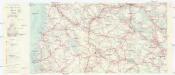
Finnland Straßenkarte
1 : 200000 Finsko Gen St d H Abt f Kr Kart u Verm W IV Mil Geo
Ostsee
1 : 100000 Baltské moře Reichs-Marine-Amt
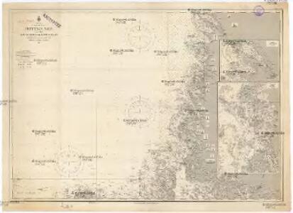
Ostsee
1 : 50400 Baltské moře Reichs-Marine-Amt
Tammerfors, Helsingfors, Reval
1 : 750000 Helsinky (Finsko) K. u. k. Militärgeographisches Institut
Finnische Schärenküste
1 : 2000000 Finnland Schärenküste
Die finnischen Schären
1 : 2000000 Finnland Schärenküste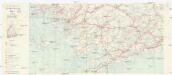
Finnland Straßenkarte
1 : 200000 Finsko Gen St d H Abt f Kr Kart u Verm W IV Mil Geo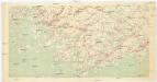
[Suomi tiekartta 1:200 000]
1 : 200000 Finsko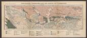
Geologische Übersichtskarte der Gegend von Tammerfors
1 : 400000 Sederholm, J.J. F. Tilgman
Ostsee
1 : 200000 Baltské moře Reichs-Marine-Amt
NORDLANDIÆ | et quibies | GESTRICIA | et | HELSINGICÆ | REGIONES
Auct. Andrea Buræo Sueco. [Amsterdam : Joan Blaeu]
Sinus Finnici delineatio geographica / ex quam plurimis subsidiis novissimis stereographice tradita
1 : 1000000 1 Karte auf 2 Blatt : Kupferdruck ; 44 x 81 cm Mayer, Tobias [Homännische Erben]
Eisenbahnkarte von Finnland
Finnland Eisenbahnnetz
Karte von Finnland
1 : 2400000 Evropa Finland Steamship
Partie, Suede, Norwege. Europe 4.
1 : 1641836 Vandermaelen, Philippe, 1795-1869
Postkarte von Finnland und Norrland
Finsko jižní Ponheimer, Kilian im von Reillyschen Landkarten und Kunstwerke Verschleiss Komptoir
Feuille 18 (D III), uit: Carte géologique internationale de l'Europe : la carte, votée au congrès géologique international de Bologne en 1881, est exécutée conformément aux décisions d'une commission internationale, avec le concours des gouvernements, sous le dir. de M.M. Beyrich et Hauchecorne
Annotatie: Blad 48 gamme des couleurs; blad 49: bladwijzer en titelblad Heinrich Ernst Beyrich 1815-1896; Wi. Hauchecorne Berlin : Reimer / (Berlin: Institut lithographique)
Karta Finljandīi s pokazanīem granic Rosīi i Švecīi po raznym dogovorom
1 : 600000 Finnland Nordischer Krieg <1700-1721>
Spesielle kart 18 Sør-øst: Telegrafkart over Norge
1 : 1000000 Den Private Opmaaling, Kristiania
Magni ducatus Finlandiae Russiae partim, partim Sueciae subjecti, sinus item Bothnici ac Finnici nova et accurata delineatio
1 : 1600000 Finsko Lotter, Tobias Conrad sumptibus Tobiae Conradi Lotter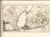

Magni Ducatus Finlandiae Russiae partim, partim Sueciae subjecti, sinus item Bothnici ac Finnici nova et accurata delineatio
1 : 1500000 [Augustae Vindelicorum] : calamo et sumptibus Matthaei Seutteri
Turkart over Hallingskarvet
Statens Kartverk
MAGNVS DVCATVS | FINLANDIÆ
Auct. Andrea Buræo Sueco. [Amsterdam : Joan Blaeu]
Magnus Ducatus Finlandiae Nova et accurata delineatio. [Karte], in: Novus atlas absolutissimus, Bd. 1, S. 48.
1 Karte aus Atlas Janssonius Offizin
Suomi
1 : 1000000 Finsko Maanmittaushallituksen kivipaino
La République de Finlande
1 : 2000000 Finsko F. Tilgmann
Trigonometrisk grunnlag, vedlegg 65, 1b: Grunnlagspunkter for Struves meridianbue fra Jyväskylä til Hrodna
1 : 1440000