Maps of Finland Proper

Tammerfors, Helsingfors, Reval
1 : 750000 Helsinky (Finsko) K. u. k. Militärgeographisches Institut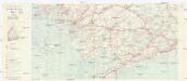
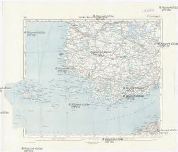
Finnland Straßenkarte
1 : 200000 Finsko Gen St d H Abt f Kr Kart u Verm W IV Mil Geo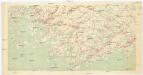
[Suomi tiekartta 1:200 000]
1 : 200000 Finsko
Die finnischen Schären
1 : 2000000 Finnland Schärenküste
Finnische Schärenküste
1 : 2000000 Finnland Schärenküste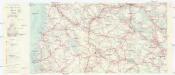
Finnland Straßenkarte
1 : 200000 Finsko Gen St d H Abt f Kr Kart u Verm W IV Mil Geo
Ostsee
1 : 150000 Baltské moře Reichs-Marine-Amt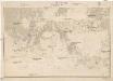
Ostsee
1 : 100000 Baltské moře Reichs-Marine-Amt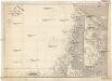
Ostsee
1 : 200000 Baltské moře Reichs-Marine-Amt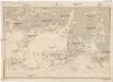
Ostsee
1 : 100000 Baltské moře Reichs-Marine-Amt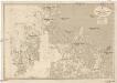
Ostsee
1 : 100000 Baltské moře Reichs-Marine-Amt
K vojně so Švecīej 1808 - 1809 gg. Karta prochoda okolo ostrova Kimito
Finnland Kimito Seeschlacht Russisch-Schwedischer Krieg <1808-1809>
Schema k dějstvījam u Ganguta v ījulě 1714 g.
Finnland Hanko Nordischer Krieg <1700-1721>
Ostsee
1 : 50000 Baltské moře Reichs-Marine-Amt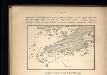
Proryv galernago flota 26 ījulja 1714 goda.
Ostsee Nordischer Krieg <1700-1721> Seeschlacht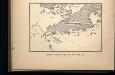
Proryv galernago flota 27 ījulja 1714 goda.
Ostsee Nordischer Krieg <1700-1721> Seeschlacht
Plan sraženīja pri r. Pelkinoj
Finnland Nordischer Krieg <1700-1721>
Etelä-Pirkkala
1 : 20000 Maanmittaushallituksen kivipaino
Ostsee
1 : 75000 Baltské moře Reichs-Marine-Amt
Kr. Sveaborg i okrestnosti putej vokrug Gel'singforsa
Finnland Suomenlinna Russisch-Schwedischer Krieg <1808-1809>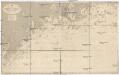
Ostsee
1 : 50000 Baltské moře Reichs-Marine-Amt
Sinus Finnici delineatio geographica / ex quam plurimis subsidiis novissimis stereographice tradita
1 : 1000000 1 Karte auf 2 Blatt : Kupferdruck ; 44 x 81 cm Mayer, Tobias [Homännische Erben]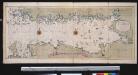
Nieuwe afteekening van de Finlandse Golff
Gulf of Finland Abraham Maas Gerard van Keulen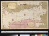
Afteekening van t agterste gedeelte van de Oost Zee van t eijlant Dago tot Schansternij
Gulf of Finland Gerard van Keulen
Oost-Zee Streckende van Dageroort tot Wyborgh [Karte in 2 Teilen], in: De Nieuwe Groote Vermeerderde Zee-Atlas ofte Water-Werelt, S. 27.
1 Karte aus Atlas Doncker, Hendrick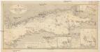
Ostsee
1 : 400000 Baltské moře Reichs-Marine-Amt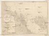
Ostsee
1 : 200000 Alandské ostrovy (Finsko : souostroví) Reichs-Marine-Amt
Fortsetzung der Hauptkarte [Estland]
1 : 5000000 Estland Weltkrieg <1914-1918>, Ostfront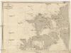
Ostsee
1 : 150000 Baltské moře Reichs-Marine-Amt