Maps of Belarus

18. Soviet Republics in North-Central The World Atlas. Europe.
1 : 3000000 USSR (Union of Soviet Socialist Republics).
Baltic States & East Prussia.
1 : 2000000 John Bartholomew and Son
Übersichtskarte des Östlichen Kriegsschauplatzes
1 : 6000000 Osteuropa Weltkrieg <1914-1918> Verl. Gerhard Stalling, Oldenburg
Nyugat – Oroszország

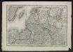
Deutsch-österreichisch-russische Grenzlande
1 : 2000000 Evropa východní Velhagen & Klasing
Paasche's Frontenkarte, Nr.4. Der Krieg gegen Russland

Trigonometrisk grunnlag, vedlegg 65, 1b: Grunnlagspunkter for Struves meridianbue fra Jyväskylä til Hrodna
1 : 1440000
Deutsch-russische Grenzlande
1 : 2000000 Evropa východní Velhagen & Klasing
Ostsee-Laender und inneres Russland bis Moskau
1 : 3700000 Moskva-oblast (Rusko) Stülpnagel, Friedrich von Ausfeld, Johann Carl Justus Perthes
Ostsee-Laender und inneres Russland bis Moskau
1 : 3700000 Moskva-oblast (Rusko) Stülpnagel, Friedrich von Ausfeld, Johann Carl Justus Perthes
[Evropa]
Evropa
Dietrich Reimer's Kriegsstandskarten. 1. 1500000, Der Kreig gegen Russland und der Kampf um die Dardanellen
1 : 1500000 Wo Stehen Unsere Armeen in Russland? 6 Ausg.,abgeschlossen am 27. Sept.1915 Dietrich Reimer Verlag Berlin : Dietrich Reimer Ernst Vohsen
Paasche's Frontenkarte, Nr.4. Der Krieg gegen Russland
Voenno-dorožnaja karta časti Rossii i pograničnych zemelʹ
1 : 1680000 Baltikum, Ostpreußen Šubert [Generalmajor]
Carte réduite de la mer Baltique, 2
1 Blatt : 73 x 60 cm Froullé
Reliefkarte der Ostsee von Danzig bis Petersburg
Gdaňsk-oblast (Polsko) Franckh'sche Verlagshandlung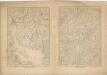
Kriegs Atlas 36 Karten von den Schauplätzen des Weltkrieges 1914/1915

Mare Balticum
1 Karte : Kupferdruck ; 49 x 57 cm Renard gedruckt by L. Renard
K vojně so Švecīej 1808 - 1809 gg.
Schweden Seeschlacht Russisch-Schwedischer Krieg <1808-1809>
Karte der Nationalitätengebiete auf dem Territorium des Grossfürstentums Litauen
Litauen Großfürstentum Litauen ethnische Gruppe Świechowski, Marian von
Russland
1 : 3360000 Estonsko Renner Kleinknecht
Prusse, Lithuanie.
1 : 3200000 Clouet, J. B. L. (Jean-Baptiste Louis), b. 1730
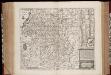
Magni dvcatvs Lithvaniae, caeterarvmqve regionvm illi adiacentivm exacta descriptio / sculptum apud
1 : 1300000 1 Karte auf 4 Blatt : Kupferdruck ; 73 x 71 cm Blaeu, Willem Janszoon excudebat Guilhelmus Janssonius sub signo solarij deaurati
Magni dvcatvs Lithvaniae, et regionum adiacentium exacta descriptio
1 : 2000000 Bělorusko Blaeu, Joan I. Blaeu
Neue militairische Situations- und Postkarte von West-Russland
1 : 1320000 Rusko západní Knittel, J. E. Fréderic Campe

Pas-caart van de Oost Zee
1 Karte : Kupferdruck ; 43 x 55 cm Doncker by Hendrick Doncker boekverkoper en graadbooghmaker inde Nieuwbrug-steegh in 't Stuurmans gereedtschap
[125][128] Mare Balticum, uit: Atlas sive Descriptio terrarum orbis
Annotatie: Gedigitaliseerde versie. Amsterdam. Heiloo : Picturae (vervaardiger), 2015. tiff-bestand. Gedigitaliseerd: 07-01-2015; Origineel: Universiteitsbibliotheek Vrije Universiteit (XL.05127.-) ; Netherlands; Titelpagina ontbreekt Wit, Frederik de Amsterdam : Frederick de Wit
MAGNI DVCATVS | LITHVANIÆ | et Regionum Adiacentium
exacta Descriptio | Ill.mi ac Excell.mi Principis et Dni. D. Nicolai Christophori Radziwil... opera, cura et impensis olim facta, ac nunc denuo hac forma edita a I. Blaeu. Ioannes Blaeu | Excudebat.