Maps of Finland

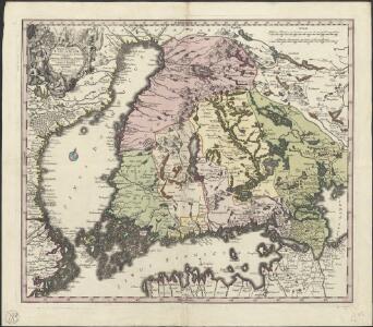
Magni Ducatus Finlandiae Russiae partim, partim Sueciae subjecti, sinus item Bothnici ac Finnici nova et accurata delineatio
1 : 1500000 [Augustae Vindelicorum] : calamo et sumptibus Matthaei Seutteri
Magnus Ducatus Finlandiae Nova et accurata delineatio. [Karte], in: Novus atlas absolutissimus, Bd. 1, S. 48.
1 Karte aus Atlas Janssonius Offizin
MAGNVS DVCATVS | FINLANDIÆ
Auct. Andrea Buræo Sueco. [Amsterdam : Joan Blaeu]
Voenno-dorožnaja karta časti Rossii i pograničnych zemelʹ
1 : 1680000 Schweden, Finnland Šubert [Generalmajor]
Das Grossfürstenthum Finland
1 : 2600000 Finsko Meissner, G. Benjamin Hermelin, S.G.
Magni ducatus Finlandiae Russiae partim, partim Sueciae subjecti, sinus item Bothnici ac Finnici nova et accurata delineatio
1 : 1600000 Finsko Lotter, Tobias Conrad sumptibus Tobiae Conradi Lotter
Karta Finljandīi s pokazanīem granic Rosīi i Švecīi po raznym dogovorom
1 : 600000 Finnland Nordischer Krieg <1700-1721>
Eisenbahnkarte von Finnland
Finnland Eisenbahnnetz
Postkarte von Finnland und Norrland
Finsko jižní Ponheimer, Kilian im von Reillyschen Landkarten und Kunstwerke Verschleiss Komptoir
Karte von Finnland
1 : 2400000 Evropa Finland Steamship
Distribution des dépôts quaternaires en Finlande
1 : 2000000 Sederholm, J.J. F. Tilgman

Suomi
1 : 1000000 Finsko Maanmittaushallituksen kivipaino
La République de Finlande
1 : 2000000 Finsko F. Tilgmann
Sinus Finnici delineatio geographica / ex quam plurimis subsidiis novissimis stereographice tradita
1 : 1000000 1 Karte auf 2 Blatt : Kupferdruck ; 44 x 81 cm Mayer, Tobias [Homännische Erben]
Die finnischen Seen
Finnland Seengebiet
Nieuwe kaart van de Finnissche Golf benevens de omliggende provintien : naar de beste kaarten en sterrekundige waarnemingen geteekend in 't Konigl. Landmeeters Comtoir te Stockholm
1 : 1200000 C. van Baarsel sculp. te Amsterdam : bij J. Covens en Zoon
Trigonometrisk grunnlag, vedlegg 65, 14-17: Grunnlagspunkter for Struves meridianbue fra Finnland
1 : 200000 de Struve | Selander
Trigonometrisk grunnlag, vedlegg 63a: Karta öfver Norra Sverige
1 : 500000 August Hahr Schlachter & Seedorff, Stockholm
Schema raīona operacīi grafa Kamenskago
Finnland Kamenskij, Nikolaj Michajlowic Russisch-Schwedischer Krieg <1808-1809>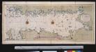
Nieuwe afteekening van de Finlandse Golff
Gulf of Finland Abraham Maas Gerard van Keulen
Nova et accurata delineatio Ingriae et Careliae cum magna parte Sinus Finnici et Lacus Ladogae, nec non insularum adjacentium
1 : 1210000 Finsko Seutter, Matthäus Matthaeus Seutter
Tammerfors, Helsingfors, Reval
1 : 750000 Helsinky (Finsko) K. u. k. Militärgeographisches Institut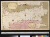
Afteekening van t agterste gedeelte van de Oost Zee van t eijlant Dago tot Schansternij
Gulf of Finland Gerard van Keulen
Oost-Zee Streckende van Dageroort tot Wyborgh [Karte in 2 Teilen], in: De Nieuwe Groote Vermeerderde Zee-Atlas ofte Water-Werelt, S. 27.
1 Karte aus Atlas Doncker, Hendrick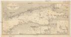
Ostsee
1 : 400000 Baltské moře Reichs-Marine-Amt
Nova et accurata delineatio Ingriae et Careliae cum magna parte sinus Finnici et lacus Ladogae, nec
1 : 610000 1 Karte : Kupferdruck ; 55 x 47 cm Seutter, Matthäus [Matthäus Seutter]
Afteekening van de Oostzee of Oost Finsche Boodem vertoonende de vaart van Revel tot St. Petersburgh int groot
Gulf of Finland Gerard van Keulen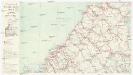
Finnland Straßenkarte
1 : 400000 Finsko Gen St d H Abt f Kr Kart u Verm W IV Mil Geo