Maps of Macedonia - Thrace

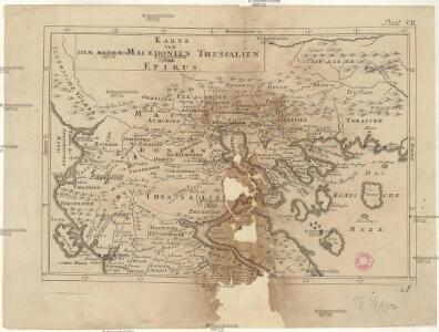
Karte von dem Alten Macedonien Thessalien und Epirus
Epirus (Řecko) Baumgarten, Siegmund Jakob Johann Justinus Gebauer
Macedonia Alexandri M. Patria Illustris. [Karte], in: Novus atlas absolutissimus, Bd. 10, S. 67.
1 Karte aus Atlas Janssonius Offizin
Mazedonien
1 : 3000000 Makedonien (Landschaft) Weltkrieg <1914-1918>
Internationale und nationale Grenzen in der Provinz Makedonien seit 1944
Makedonien Grenzen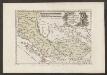
Der Südliche Theil Des Koenigreichs Albanien mit der Landschaft Thessalien
1 : 1300000 Albanien, Thessalien
Carte de la Macédoine d'une partie de l'Albanie, de l'Epire et de la Thessalie
1 : 800000 Albánie Lapie, Pierre Kaeppelin Société geologique de France
Der von der IMRO geplante Mazedonische Staat
Makedonien Innere Makedonische Revolutionäre Organisation
Ancient Greece, northern.
1 : 1500000 Society for the Diffusion of Useful Knowledge (Great Britain)
Turkey II. Northern Greece.
1 : 1500000 Society for the Diffusion of Useful Knowledge (Great Britain)
Carte ethnographique de la Macédoine, Point de vue serbe
Makedonien Ethnische Gruppe Th. Weinreb del.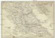
Turkey
1 : 1500000 Albánie Walker, C. Baldwin & Cradock
Ancient Greece : northern part
1 : 1500000 published under the superintendence of the Society for the Diffusion of Useful Knowledge engraved by J. & C. Walker London : Baldwin and Cradock
Carte ethnographique de la Macédoine, Point de vue bulgare
Makedonien Ethnische Gruppe Th. Weinreb del.
Turkey II : containing the northern part of Greece
published under the superintendence of the Society for the Diffusion of Useful Knowledge engraved by J. & C. Walker London : Baldwin and Cradock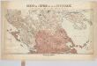
Carte de l'Épire et de la Thessalie : die griechisch-türkischen Grenzgebiete mit Angabe der griechischen Sprachgrenze / dressée par H. Kiepert
1 : 500000 titelvariant: Specialkarte der griechisch-türkischen Grenzgebiete; Annotatie: Omslagtitel: Carte de l'Épire et de la Thessalie : Specialkarte der griechisch-türkischen Grenzgebiete mit Angabe der griechischen Sprachgrenze; Boven de titel ook: Kriegsschauplatz; Gevouwen in omslag; Annotatie geografische gegevens: Met 7 schaalstokken; Legenda Johann Samuel Heinrich Kiepert 1818-1899 Berlin : Dietrich Reimer (Ernst Vohsen)
Übersichtskarte von Mittel - Europa

Übersichtskarte von Mittel - Europa

Übersichtskarte von Mittel - Europa

Saloniki, Seres, Xanthi, Kastro, Pharsalos
1 : 750000 Fársala (Řecko) Budik, A. K. u. k. Militärgeographisches Institut
Salonik, Seres, Xanthi, Kastro, Phersala
1 : 750000 Soluň (Řecko) K. k. militär-geographisches Institut
Elbasan, Argyrokastron, Joannina, Corfu, Philiataes
1 : 750000 Korfu (Řecko : ostrov) Nimmerfroh, J. K. u. k. Militärgeographisches Institut
Elbasan, Argyrokastron, Janina, Korfu, Philiataes
1 : 750000 Korfu, ostrov (Řecko) Nimmerfroh, J. Wohlstein, K. K. u. k. Militärgeographisches Institut
Elbasan, Argyrokastron, Joannina, Corfu, Philiataes
1 : 750000 Korfu (Řecko : ostrov) K. k. militär-geographisches Institut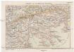
Saloniki und die Halbinsel Chalkidike
1 : 1250000 Chalkidiki (Řecko) Freytag & Berndt
Thessaliae accurata Descriptio [Karte], in: Novus atlas absolutissimus, Bd. 10, S. 89.
1 Karte aus Atlas Janssonius Offizin
Národopisná mapka Macedonie
Makedonie Král z Dobré Vody, Vojtěch Kančov, Vasil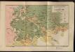
Etnografska karta na Makedonija
Makedonien Ethnische Gruppe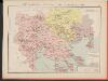
Carte des écoles et églises du vilayet de Salonique (1908)
Griechenland Selanik