Maps of Epirus - Western Macedonia
Carte de l'Épire et de la Thessalie : die griechisch-türkischen Grenzgebiete mit Angabe der griechischen Sprachgrenze / dressée par H. Kiepert
1 : 500000 titelvariant: Specialkarte der griechisch-türkischen Grenzgebiete; Annotatie: Omslagtitel: Carte de l'Épire et de la Thessalie : Specialkarte der griechisch-türkischen Grenzgebiete mit Angabe der griechischen Sprachgrenze; Boven de titel ook: Kriegsschauplatz; Gevouwen in omslag; Annotatie geografische gegevens: Met 7 schaalstokken; Legenda Johann Samuel Heinrich Kiepert 1818-1899 Berlin : Dietrich Reimer (Ernst Vohsen)
Turkey II : containing the northern part of Greece
published under the superintendence of the Society for the Diffusion of Useful Knowledge engraved by J. & C. Walker London : Baldwin and Cradock
Ancient Greece : northern part
1 : 1500000 published under the superintendence of the Society for the Diffusion of Useful Knowledge engraved by J. & C. Walker London : Baldwin and Cradock
Ancient Greece, northern.
1 : 1500000 Society for the Diffusion of Useful Knowledge (Great Britain)
Turkey II. Northern Greece.
1 : 1500000 Society for the Diffusion of Useful Knowledge (Great Britain)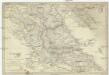
Turkey
1 : 1500000 Albánie Walker, C. Baldwin & Cradock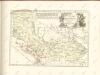
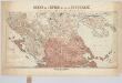
Macedonia Alexandri M. Patria Illustris. [Karte], in: Novus atlas absolutissimus, Bd. 10, S. 67.
1 Karte aus Atlas Janssonius Offizin
Grèce, Albanie et Thessalie
Nouvel atlas physique politique et historique de l'Empire ottoman et des états limitrophes en Europe, en Asie et en Afrique, en quarante feuilles Hellert, J.J. Bellizard, Dufour et Cie
Thessaliae accurata Descriptio [Karte], in: Novus atlas absolutissimus, Bd. 10, S. 89.
1 Karte aus Atlas Janssonius Offizin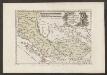
Der Südliche Theil Des Koenigreichs Albanien mit der Landschaft Thessalien
1 : 1300000 Albanien, Thessalien
Westlicher Kriegsschauplatz
1 : 303000 Preveza-oblast (Řecko) D. Kuh
Thessalie et Macédoine méridionale
Griechenland Makedonien Thessalien Geländedarstellung Eisenbahnlinie
Carte des écoles et des églises grecques de l'Epire
1 : 500000 Athènes :
Carte des écoles et églises du vilayet de Jannina (1908)
Griechenland Vilâyet Yanya Osmanisches Reich Kirchenbau Schulgebäude Kümmerly & Frey
Übersichtskarte von Mittel - Europa

Übersichtskarte von Mittel - Europa

Elbasan, Argyrokastron, Joannina, Corfu, Philiataes
1 : 750000 Korfu (Řecko : ostrov) Nimmerfroh, J. K. u. k. Militärgeographisches Institut
Elbasan, Argyrokastron, Janina, Korfu, Philiataes
1 : 750000 Korfu, ostrov (Řecko) Nimmerfroh, J. Wohlstein, K. K. u. k. Militärgeographisches Institut
Elbasan, Argyrokastron, Joannina, Corfu, Philiataes
1 : 750000 Korfu (Řecko : ostrov) K. k. militär-geographisches Institut
Vera designatio insulae Corcyrae, Portus & Munitionum vera cum parte Epriri Accomodata ad Nostra Tempora. [Karte], in: Geographia universalis vetus et nova complectens Claudii Ptolemaei Alexandrini enarrationis libros VIII, S. 237.
1 Karte aus Atlas Münster, Sebastian [und Ptolemaeus, Claudius]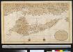
Nieuwe afteekening van 't eijland Corfu geleegen in de Middelantsche Zee in t incoomen van de Golf van Venetia
Greece Gerard van Keulen
Carte normale aeronautique internationale
1 : 200000 Geografike yperesia strarou

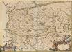
Insularum Aliquot Maris Mediterranei Descriptio. [Corfu.] [Karte], in: Theatrum orbis terrarum, S. 240.
1 Karte aus Atlas Ortelius, Abraham
Insularum Aliquot Maris Mediterranei Descriptio. [Corfu.] [Karte], in: Theatrum orbis terrarum, S. 335.
1 Karte aus Atlas Ortelius, Abraham Vrients, Jan Baptista
Adriatisches Meer, Küsten-Karte
1 : 180000 Jaderské moře (oblast) Oesterreicher, Tobias von Hydrographisches Amt der k. u. k. Kriegs-Marine
Nova et accurata geographica tabula insulae Corfu seu Corcyrae cum confiniis suis, ac portubus ex adverso in Graecia jacentibus
1 : 150000 autore Joachimo Ottens Amstelodamensi Te Amsterdam : by Joachim Ottens [...]
Insularum Aliquot Maris Mediterranei Descriptio. [Corfu.] [Karte], in: Theatrum orbis terrarum, S. 91.
1 Karte aus Atlas Ortelius, Abraham


