Maps of Pindus Mountains

Übersichtskarte von Mittel - Europa

Übersichtskarte von Mittel - Europa

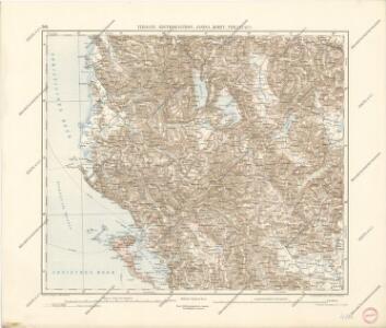
Elbasan, Argyrokastron, Joannina, Corfu, Philiataes
1 : 750000 Korfu (Řecko : ostrov) Nimmerfroh, J. K. u. k. Militärgeographisches Institut
Elbasan, Argyrokastron, Janina, Korfu, Philiataes
1 : 750000 Korfu, ostrov (Řecko) Nimmerfroh, J. Wohlstein, K. K. u. k. Militärgeographisches Institut
Elbasan, Argyrokastron, Joannina, Corfu, Philiataes
1 : 750000 Korfu (Řecko : ostrov) K. k. militär-geographisches Institut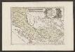
Der Südliche Theil Des Koenigreichs Albanien mit der Landschaft Thessalien
1 : 1300000 Albanien, Thessalien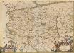
Macedonia Alexandri M. Patria Illustris. [Karte], in: Novus atlas absolutissimus, Bd. 10, S. 67.
1 Karte aus Atlas Janssonius Offizin
Karte von Albanien
1 : 1480000 Albánie
G. Freytags Karte des Fürstenthums Albanien
1 : 600000 Albánie Freytag, Gustav Kartogr. Anstalt G. Freytag & Berndt
Shqiperia
1 : 500000 Albánie
Carte des écoles et églises du vilayet de Monastir (1908)
Makedonien Vilâyet Manastır Osmanisches Reich Kirchenbau Schulgebäude Kümmerly & Frey
Carte de l' Albanie
Albánie Karacsay, Fedor
Albania
1 : 500000 Albánie Consociazione turistica italiana
Albanie (Races et Religions)
Albanien Ethnische Gruppe Denomination
Carte des écoles et des églises grecques de l'Epire
1 : 500000 Athènes :
Carte des écoles et églises du vilayet de Jannina (1908)
Griechenland Vilâyet Yanya Osmanisches Reich Kirchenbau Schulgebäude Kümmerly & Frey
Urban Growth, 1965-1987
Albanien Städtewachstum
The Towns of Albania (as of 4 March, 1989)
Albanien Städtenetz
Albánie

Commentari rerum Graecorum
Griechenland Albanien
Adriatisches Meer, Küsten-Karte
1 : 180000 Jaderské moře (oblast) Oesterreicher, Tobias von Hydrographisches Amt der k. u. k. Kriegs-Marine
Muzakja Gebiet
Albanien Péch, Béla
Vera designatio insulae Corcyrae, Portus & Munitionum vera cum parte Epriri Accomodata ad Nostra Tempora. [Karte], in: Geographia universalis vetus et nova complectens Claudii Ptolemaei Alexandrini enarrationis libros VIII, S. 237.
1 Karte aus Atlas Münster, Sebastian [und Ptolemaeus, Claudius]
Bitolj
1 : 200000 Bitola (Makedonie) Kartografska radionica
Karta okresnostej Ochridskago i Prespanskago ozer
Ohrid-oblast (Makedonie) Grigorowič
Elbasan
1 : 200000 Kartografska radionica
Insularum Aliquot Maris Mediterranei Descriptio. [Corfu.] [Karte], in: Theatrum orbis terrarum, S. 335.
1 Karte aus Atlas Ortelius, Abraham Vrients, Jan Baptista
Korytsa
1 : 100000 Albánie Geografiké ypéresia stratou
Korfu
1 : 1000000 Korfu