Maps of Pindus Mountains

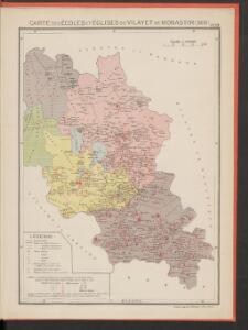
Carte des écoles et églises du vilayet de Monastir (1908)
Makedonien Vilâyet Manastır Osmanisches Reich Kirchenbau Schulgebäude Kümmerly & Frey
Übersichtskarte von Mittel - Europa

Elbasan, Argyrokastron, Joannina, Corfu, Philiataes
1 : 750000 Korfu (Řecko : ostrov) Nimmerfroh, J. K. u. k. Militärgeographisches Institut
Elbasan, Argyrokastron, Janina, Korfu, Philiataes
1 : 750000 Korfu, ostrov (Řecko) Nimmerfroh, J. Wohlstein, K. K. u. k. Militärgeographisches Institut
Elbasan, Argyrokastron, Joannina, Corfu, Philiataes
1 : 750000 Korfu (Řecko : ostrov) K. k. militär-geographisches Institut
Übersichtskarte von Mittel - Europa

Ligne de partage d'après la carte annexée au traité d'alliance
Balkanhalbinsel Grenze Balkankrieg <1912-1913> Annexion
Ligne de partage d'après la carte annexée au Traité d'Alliance
Bulgarien Serbien Balkankrieg <1912-1913> Territorialer Anspruch Th. Weinreb del.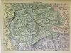
Süd-Serbien
1 : 800000 Serbien (Süd)
Bitolj
1 : 200000 Bitola (Makedonie) Kartografska radionica
Karta okresnostej Ochridskago i Prespanskago ozer
Ohrid-oblast (Makedonie) Grigorowič
Vormarsch der 1. Armee nach der Schlacht bei Kumanowo bis zur Schlacht bei Bitolj (Monastir)
Makedonien Balkankrieg <1912-1913> Kumanovo / Schlacht
Korytsa
1 : 100000 Albánie Geografiké ypéresia stratou
Westliches Mazedonien
1 : 600000 Makedonien (Landschaft)
Elbasan
1 : 200000 Kartografska radionica
Vodena
1 : 200000 Kartografska radionica
Plan der Ebene Von Ianina in Albanien
Ioannina Barbié du Bocage, Jean Denis
Plan grada Skoplja
1 : 7500 Skopje (Makedonie) Zadužbinska štamparija Vardarske Banovine Nemanja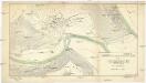
Stereophotogrammetrische Aufnahme des Treskatales (Neuserbien) im Jahre 1914
1 : 2000 Makedonie Konsortium Luftbild, Stereographik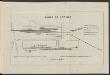
Gares de Larissa
Griechenland Larisa Bahnhof Gleisanlage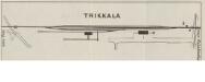
Trikkala; Vélestino [Teilkarte Trikala]
1 : 4000 Griechenland Trikala Belestinon Bahnhof Gleisanlage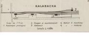
Carditza; Kalabacka [Teilkarte Kalambaka]
1 : 4000 Griechenland Kalambaka Gleisanlage Bahnhof
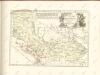
Carte de la Macédoine d'une partie de l'Albanie, de l'Epire et de la Thessalie
1 : 800000 Albánie Lapie, Pierre Kaeppelin Société geologique de France
Carte ethnographique de la Macédoine, Point de vue bulgare
Makedonien Ethnische Gruppe Th. Weinreb del.
Siedlungsgebiet der Albaner
Balkanhalbinsel Albaner, Siedlung
Carte ethnographique de la Macédoine, Point de vue serbe
Makedonien Ethnische Gruppe Th. Weinreb del.
Der von der IMRO geplante Mazedonische Staat
Makedonien Innere Makedonische Revolutionäre Organisation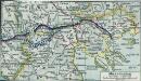
Mazedonien
1 : 3000000 Makedonien (Landschaft) Weltkrieg <1914-1918>