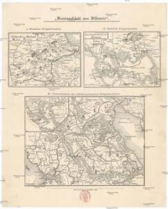
Maps of Epirus - Western Macedonia

Westlicher Kriegsschauplatz
1 : 303000 Preveza-oblast (Řecko) D. Kuh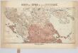
Carte de l'Épire et de la Thessalie : die griechisch-türkischen Grenzgebiete mit Angabe der griechischen Sprachgrenze / dressée par H. Kiepert
1 : 500000 titelvariant: Specialkarte der griechisch-türkischen Grenzgebiete; Annotatie: Omslagtitel: Carte de l'Épire et de la Thessalie : Specialkarte der griechisch-türkischen Grenzgebiete mit Angabe der griechischen Sprachgrenze; Boven de titel ook: Kriegsschauplatz; Gevouwen in omslag; Annotatie geografische gegevens: Met 7 schaalstokken; Legenda Johann Samuel Heinrich Kiepert 1818-1899 Berlin : Dietrich Reimer (Ernst Vohsen)
Thessalie et Macédoine méridionale
Griechenland Makedonien Thessalien Geländedarstellung Eisenbahnlinie
Carte normale aeronautique internationale
1 : 200000 Geografike yperesia strarou
Plan der Ebene Von Ianina in Albanien
Ioannina Barbié du Bocage, Jean Denis
Stations de Démirly
Griechenland Bahnhof Paleofarsalos
Plan de Volo
Griechenland Volos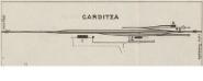
Carditza; Kalabacka [Teilkarte Karditsa]
1 : 4000 Griechenland Karditsa Kalambaka Bahnhof Gleisanlage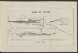
Gares de Larissa
Griechenland Larisa Bahnhof Gleisanlage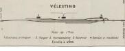
Trikkala; Vélestino [Teilkarte Belestinon]
1 : 4000 Griechenland Belestinon Gleisanlage Bahnhof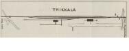
Trikkala; Vélestino [Teilkarte Trikala]
1 : 4000 Griechenland Trikala Belestinon Bahnhof Gleisanlage
Gare de Volo
Griechenland Volos Bahnhof Gleisanlage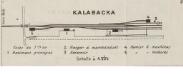
Carditza; Kalabacka [Teilkarte Kalambaka]
1 : 4000 Griechenland Kalambaka Gleisanlage Bahnhof
Plan von Thermopylae auf die Zeit des Einfalls des Xerxes in Griechenland angewendet
1 : 80000 Barbié du Bocage, Jean Denis
Plan de la place du Corfu avec ses environs, assiegee par les infideles tranchee ouverte le 25me de iuillet jusqu'au 22 d' out. iour, de la fuite des Ottomans, defendüe par S. E. le Feldt Marechal Comte de Schulembourg, general en chef armées de la Ser. Rep[ubli]que de Veniseen l'an 1716
1 : 190000 Korfu (Řecko) Homann, Johann Baptist Schulenburg, Matthias Johann von der Iean Baptise Homann
Grèce, Albanie et Thessalie
Nouvel atlas physique politique et historique de l'Empire ottoman et des états limitrophes en Europe, en Asie et en Afrique, en quarante feuilles Hellert, J.J. Bellizard, Dufour et Cie
Turkey II : containing the northern part of Greece
published under the superintendence of the Society for the Diffusion of Useful Knowledge engraved by J. & C. Walker London : Baldwin and Cradock
Ancient Greece : northern part
1 : 1500000 published under the superintendence of the Society for the Diffusion of Useful Knowledge engraved by J. & C. Walker London : Baldwin and Cradock
Ancient Greece, northern.
1 : 1500000 Society for the Diffusion of Useful Knowledge (Great Britain)
Turkey II. Northern Greece.
1 : 1500000 Society for the Diffusion of Useful Knowledge (Great Britain)
Turkey
1 : 1500000 Albánie Walker, C. Baldwin & Cradock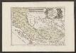
Der Südliche Theil Des Koenigreichs Albanien mit der Landschaft Thessalien
1 : 1300000 Albanien, Thessalien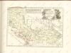
Macedonia Alexandri M. Patria Illustris. [Karte], in: Novus atlas absolutissimus, Bd. 10, S. 67.
1 Karte aus Atlas Janssonius Offizin
Die türkisch-griechischen Grenzgebiete
1 : 600000 Balkánský poloostrov Handtke, Friedrich Carl Flemming
Graecia.
1 : 1250000 Kiepert, Heinrich, 1818-1899
Balkans 1 000 000e. Salonique
1 : 1000000 France. Service géographique de l'armée [Paris] : Service géographique de l'armée
Thessaliae accurata Descriptio [Karte], in: Novus atlas absolutissimus, Bd. 10, S. 89.
1 Karte aus Atlas Janssonius Offizin
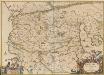
Graeciae pars borealis.
1 : 3100000 Fenner, Rest.