Maps of Albania

Carte de la Macédoine d'une partie de l'Albanie, de l'Epire et de la Thessalie
1 : 800000 Albánie Lapie, Pierre Kaeppelin Société geologique de France
Die albanischen Grenzen
Albanien Grenzen Häusler, Ines
Schematische Skizze zur Bandenbewegung in Macedonien
1 : 1500000 Makedonie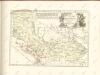

Siedlungsgebiet der Albaner
Balkanhalbinsel Albaner, Siedlung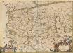
Macedonia Alexandri M. Patria Illustris. [Karte], in: Novus atlas absolutissimus, Bd. 10, S. 67.
1 Karte aus Atlas Janssonius Offizin
Karte von dem Alten Macedonien Thessalien und Epirus
Epirus (Řecko) Baumgarten, Siegmund Jakob Johann Justinus Gebauer
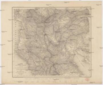
Der Südliche Theil Des Koenigreichs Albanien mit der Landschaft Thessalien
1 : 1300000 Albanien, Thessalien
Carte ethnographique de la Macédoine, Point de vue bulgare
Makedonien Ethnische Gruppe Th. Weinreb del.
Carte ethnographique de la Macédoine, Point de vue serbe
Makedonien Ethnische Gruppe Th. Weinreb del.
Map of Albania.
1 : 865000 Melish, John
Gewässerkarte von Albanien
Albanien Hydrologie Péch, Béla
Der von der IMRO geplante Mazedonische Staat
Makedonien Innere Makedonische Revolutionäre Organisation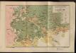
Etnografska karta na Makedonija
Makedonien Ethnische Gruppe
Karta Nove Srbije
1 : 1200000 Serbien Makedonien Bukarest / Friede <1913> Staatsgrenze Lazić, Ant.
Národopisná mapka Macedonie
Makedonie Král z Dobré Vody, Vojtěch Kančov, Vasil
Neubertova podrobná příruční mapa Abanie

Übersichtskarte von Mittel - Europa

Übersichtskarte von Mittel - Europa

Elbasan, Argyrokastron, Joannina, Corfu, Philiataes
1 : 750000 Korfu (Řecko : ostrov) Nimmerfroh, J. K. u. k. Militärgeographisches Institut
Elbasan, Argyrokastron, Janina, Korfu, Philiataes
1 : 750000 Korfu, ostrov (Řecko) Nimmerfroh, J. Wohlstein, K. K. u. k. Militärgeographisches Institut
Elbasan, Argyrokastron, Joannina, Corfu, Philiataes
1 : 750000 Korfu (Řecko : ostrov) K. k. militär-geographisches Institut
G. Freytags Karte des Fürstenthums Albanien
1 : 600000 Albánie Freytag, Gustav Kartogr. Anstalt G. Freytag & Berndt
Karte der Flußgebiete des Drin und des Wardar
1 : 500000 Vardar-Gebiet Flusssystem Hahn, Johann Georg von
Albanie (Races et Religions)
Albanien Ethnische Gruppe Denomination
Karte von Albanien
1 : 1480000 Albánie
Albania
1 : 500000 Albánie Consociazione turistica italiana
Carte de l' Albanie
Albánie Karacsay, Fedor
Shqiperia
1 : 500000 Albánie